Albright Grove Loop Trail Highlights
- Trail Features
Old Growth Forest, History, Solitude
- Trail Location
Cosby
- Roundtrip Length
6.7 Miles
- Elevation Gain (total)
1475 Feet
- Elevation Gain (per mile)
440 Feet
- Trail Difficulty
9.65
Moderately Difficult
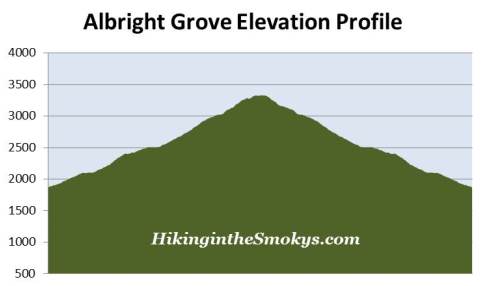
This moderately difficult hike is 6.7 miles roundtrip and includes 1475 feet of elevation gain.
Albright Grove Loop Trail Description
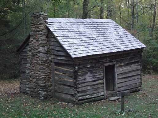
The Maddron Bald Trail was built by the Civilian Conservation Corps in the early 1930s, which operated from a camp near the trailhead. The route is actually an old gravel road, which travels along a mild to moderate grade over the course of the first 2.3 miles. The trail passes through a pleasant mixed forest of rhododendron, and coniferous and deciduous trees. It temporarily levels-off as it passes a one-room log cabin, known as the Baxter Cabin, located roughly seven-tenths of a mile from the trailhead. The cabin, built in 1889 by Willis Baxter as a wedding present for his son, was constructed from one giant chestnut tree. The original chicken coop from the homestead was eventually moved to the Mountain Farm Museum near the Oconaluftee Visitor Center in North Carolina.
At 1.2 miles the trail reaches a fairly large open area where the Gabes Mountain Trail and the Old Settlers Trail intersects with the Maddron Bald Trail. The Old Settlers Trail is one of the longest trails in the park. It stretches westward for 15.9 miles and connects the Maddron Bald Trail with Greenbrier. The Gabes Mountain Trail travels in the opposite direction, and leads hikers to the Cosby Campground. The Maddron Bald Trail continues southward, and rises gradually along the slopes above the Indian Camp Creek valley.
Maddron Bald is named for Lawson Maddron (c. 1809-1896), a prominent Cocke County minister. The old Maddron family cemetery is also located near this four-way intersection.
As you proceed along the lower portions of the route, keep an eye out for a couple of old stone walls, remnants from the old homesteads in this area.
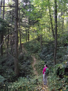
At roughly 2.3 miles the wide gravel road finally gives way to a dirt path. From this point forward the footpath narrows and begins passing through sections of old-growth forest.
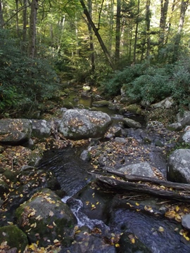
At just under 2.8 miles the trail crosses over Indian Camp Creek, and then begins ascending steeply towards the lower Albright Grove Loop Trail junction, located roughly 2.9 miles from the trailhead. To visit the grove, hikers should veer right onto the loop trail at this junction.
The Albright Grove Loop Trail is a 0.65-mile semi-loop that returns back to the Maddron Bald Trail further up the trail.
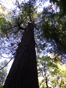
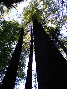
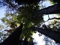
Albright Grove is an excellent example of an old-growth cove hardwood forest, which is one of the most diverse forest types in North America, and the most abundant type in the Smokies. As a result, the grove contains some of the oldest and tallest trees in the park. Unfortunately, during the first half of the 20th century, most of the large hardwood trees in the Great Smoky Mountains were cleared by loggers or killed by blights, such as the devastating chestnut blight. Although Albright Grove has suffered through blights and infestations over the years, it was mostly spared by the lumber companies. Today, eastern hemlock and tulip poplars dominate this protected grove. Hikers will also find buckeye, yellow birch, fraser magnolias, silverbells, basswood, beeches and sugar maples.
The loop trail climbs for a third-of-a-mile before leveling off, and then begins to descend back down towards the main trail. Near the point where it begins to descend, look for a short spur trail that leads to a giant tuliptree on the left. Walk for only a few yards off the main trail and you'll reach the largest tree in Albright Grove, a tuliptree that stands more than 135 feet in height, and has a circumference of more than 25 feet!
Unfortunately many of the old trees in the grove are in the process of dying, or are already dead, and are simply waiting for a strong wind to blow them over. As you navigate around the loop you'll find that the most scenic part of Albright Grove is located along the last quarter-mile of the loop.
The grove is named after Horace Albright (1890-1987), the second director of the National Park Service who held office between 1929 and 1933. Albright was among the early advocates for national park status for the Great Smoky Mountains.
At roughly 3.55 miles hikers will reach the upper Albright Grove Loop Trail / Maddron Bald Trail junction. If you still have plenty of energy and want an extra challenge, take a right at this junction. This will lead you to Maddron Bald, a 5212-foot mountain crowned by one of the park's most substantial heath balds, located roughly 3 miles away.
If you wish to complete the loop and return to the trailhead, turn left at this junction. At just over 3.75 miles hikers will reach the lower Albright Grove Loop Trail junction. From this point simply retrace your steps to return back to the trailhead.
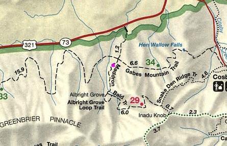
Albright Grove Loop Trail Map
Albright Grove Loop Trail Elevation Profile
Directions to Trailhead:
The hike to Albright Grove in the Great Smoky Mountains begins from the Maddron Bald Trailhead. To reach the trailhead from the junction of 441 and 321 in Gatlinburg (Light 3), head north (east) onto 321/73. Drive 15.4 miles and turn right onto Baxter Road, which is located just past the Imagination Mountain Camp Resort (formerly known as the Great Smoky Jellystone Camp). Drive about 0.4 miles (passing some private homes) and look for a sign for the Maddron Bald Trailhead on the right. After taking a hard right turn, drive roughly 100 feet down to the trailhead where there's room for a handful of vehicles. The Albright Grove Loop Trail is accessed from the Maddron Bald Trailhead. Due to some theft and vandalism issues here in the past, overnight backpackers may want to consider parking at nearby businesses on US 321, which provide this service for a fee.