Andrews Bald Highlights
- Trail Features
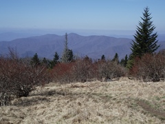
Outstanding views
- Trail Location
Clingmans Dome Area
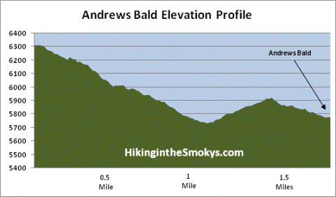
- Roundtrip Length
3.5 Miles
- Elevation Gain (total)
899 Feet
- Elevation Gain (per mile)
514 Feet
- Trail Difficulty
5.30
Moderately Difficult
This moderately difficult hike is 3.5 miles roundtrip and includes 899 feet of elevation gain.
Andrews Bald Description
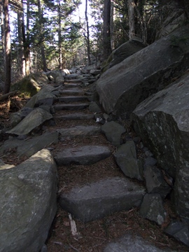
Back in the day, the hike to Andrews Bald used to traverse one of the most rugged and rocky trails in Great Smoky Mountains National Park. For many years the upper portions of the Forney Ridge Trail was an extremely rugged pathway, characterized by loose gravel, small boulders, uneven surfaces and drainage run-off. Fortunately the Friends of the Smokies, through the Trails Forever program, made some much needed improvements to this section of trail beginning in the fall of 2008. During the multi-year project crews worked to rebuild the hiking trail by placing flat stones along several segments of the path, constructed staircases out of locust wood and native rock, and installed drainage structures and elevated boardwalks.
As a result, hiking out to Andrews Bald is much easier now than in years past. Thanks to Trails Forever crews the trail is much easier on the knees and ankles, not to mention it's also a lot safer now.
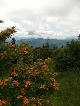
Most importantly, however, Andrews Bald remains an outstanding destination for hikers seeking spectacular views of the Great Smoky Mountain highlands. The hike is just long enough to escape the crowds at Clingmans Dome, but short enough for the entire family to enjoy.
The hike begins with a descent down the southern flank of Clingmans Dome, also known as Forney Ridge. Just after World War II this general area was the site of a major military plane crash. On June 12, 1946, a B-29 Flying Superfortress, enroute from Chicago to Florida, smashed into Clingmans Dome during a night navigational flight. The aircraft crashed just north of the Appalachian Trail, roughly one-eigth of a mile to the east of where the Clingmans Dome Tower now stands. Upon impact the wings were sheared off, while the fuselage continued on towards Clingmans Dome Road. The Park Superintendent at the time said that the wreckage was strewn over an acre or more of ground. All 12 men aboard the plane were killed.
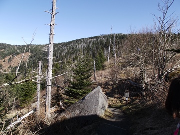
This first section of trail passes through a spruce-fir forest, which typically occupies the higher elevations of the Southern Appalachian Mountains, and is basically a relic of the last ice age. You'll immediately notice that many of the trees in this area are dead, or in the process of dying. This is mostly the result of the balsam woolly adelgid, a small insect that infests and kills Fraser firs. Since these trees have little natural defense against the adelgids, which were first introduced from Europe in the early 1900s, more than 90% of the Fraser firs in Great Smoky Mountains National Park have already been killed.
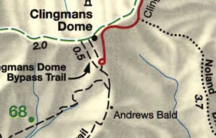
At just over one-tenth of a mile from the trailhead the Clingmans Dome Bypass Trail branches off to the right. This connector path leads to the Appalachian Trail. To continue on towards Andrews Bald hikers should turn left at this junction.
Roughly one mile from the trailhead the Forney Creek Trail will also branch off to the right. This trail eventually dead-ends into Lakeshore Trail near Backcountry Campsite 74, roughly 11.4 miles towards the south. From this junction hikers should proceed straight ahead to continue towards Andrews Bald.
At roughly 1.7 miles hikers will reach the outskirts of Andrews Bald. For the best views hikers should continue on for another hundred yards or so. From here you'll have several acres of open grassy meadow from which to choose a picnic spot, or to simply take in the spectacular panoramic vistas. From this vantage point you'll have stunning views of Fontana Lake and the southern Smokies.
High elevation grassy meadows in the Southern Appalachian Mountains are known as balds. Andrews Bald has the distinction of being the highest bald in the Great Smoky Mountains, however, without periodic maintenance from the National Park Service, both Andrews Bald and Gregory Bald would be reclaimed by natural forest growth. Both balds are also known for their spectacular displays of flame azalea and rhododendron blooms during the late spring and early summer time period. Peak bloom for flame azaleas atop Andrews Bald usually occurs around early July. My new book on the history of hiking has much more information about the balds and how they were used by the early settlers, as well as the development of the trail system across the crest of the Smokies during the early years of the park.
All in all, this is one of the best hikes in the Smokies. I'm not the only one who thinks this either! This is a very popular hike, so it's best to start as early in the morning as possible if you wish to avoid the crowds, especially on weekends during peak tourist seasons.
Andrews Bald Map
Andrews Bald Elevation Profile
Directions to Trailhead:
The hike to Andrews Bald in the Great Smoky Mountains begins from Clingmans Dome. From the Sugarlands Visitor Center near Gatlinburg, drive 13.2 miles south along Newfound Gap Road to Clingmans Dome Road. Turn right onto Clingmans Dome Road and drive another 7 miles to the end of the road. Due to its popularity, the parking area for the highest point in the Smokies is quite large. Andrews Bald is accessed via the Forney Ridge Trail, which is located at the far end of the parking lot.
From Cherokee, drive 20 miles north on Newfound Gap Road to reach Clingmans Dome Road.