Avent Cabin Highlights
- Trail Features
History, Quiet Forest Hike
- Trail Location
Elkmont
- Roundtrip Length
2.0 Miles
- Elevation Gain (total)
505 Feet
- Elevation Gain (per mile)
505 Feet
- Trail Difficulty
3.01
Easy
This easy hike is 2.0 miles roundtrip and includes 505 feet of elevation gain.
Avent Cabin Description
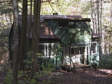
From the fairly large parking area, walk through the gate on the far end of the road to begin your hike along the Jakes Creek Trail. Almost immediately you'll begin passing the remnants of several old cottages. Most of these cottages were built in the 1920s, and were used as summer homes by the affluent from the Knoxville area. As of this writing most of the homes along this trail have been razed by the National Park Service. The only artifacts that remain are the chimneys, stone walls, and a few other rock structures that were once part of these homes. The former home of Colonel David C. Chapman also survives, and appears to be one of the few structures that will be preserved and fully restored by the park (see photo on right). Colonel Chapman played an instrumental role in the establishment of Great Smoky Mountains National Park. According to National Park Service documents, the Great Smoky Mountains plans to fully restore 19 structures in the Elkmont District so that they can be opened and viewed by the public. As part of the first phase of the Elkmont restoration project, the National Park Service reopened the old Appalachian Clubhouse for public rental in June of 2011.
After walking roughly one-third of a mile along the old gravel road the Cucumber Gap Trail will branch off towards the left. Hikers should continue by proceeding straight ahead here. A short distance from this junction is the Meigs Mountain Trail, which forks off to the right.
After passing the two trail junctions, continue up the Jakes Creek Trail for roughly four-tenths of a mile. Locating the short, unmarked spur trail to the Avent Cabin can be a bit of a challenge. You'll need to take your time and keep your eyes focused on the right side of the trail. At roughly four-tenths of a mile from the Meigs Mountain Trail junction there will be a short, but noticeable left-hand crook in the footpath. At this crook the trail also passes over a shallow creek. From this point you should travel another 25-30 yards and begin looking for a slight indentation in the trail that leads off to the right. You’ll know you’ve reached the correct spur trail when you see a set of wooden steps leading directly off the side of the trail. If you have a GPS, the coordinates for this junction are 35.63731 -83.58477.
From the wooden steps the short spur trail leads downhill to cross over Jakes Creek. After crossing a rather long footbridge you’ll continue walking up the hill on the opposite side for another 50 yards or so to reach the cabin. Although it’s not an official trail, the footpath is very easy to follow. However, during rainy weather, the path becomes very slick and muddy.
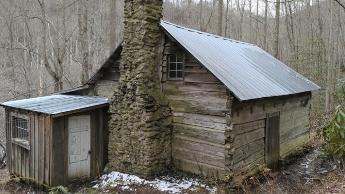
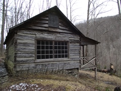
The historic cabin was built by Humphrey Ownby in 1845. It received its current name after being sold to Frank Avent in 1918. Frank's wife, Mayna Treanor Avent, used the cabin as an art studio until 1940. Though the park purchased the cabin in 1932, the Avent family retained a lifetime lease, and used the cabin until 1992. Two years later the cabin was placed on the National Register of Historic Places.
Born in Nashville, TN in 1868, Mayna Treanor Avent would become a nationally renowned artist. After studying at the Cincinnati Art Academy she enrolled at the Academie Julien in Paris where she studied art for another two years. Mayna was famous for painting a variety of subjects in both oil and watercolors. She also carved woodblocks to create prints in the Japanese style. Her works have been exhibited across America, including the Smithsonian Institute's National Portrait Gallery. You can learn more about Mayna in Women of the Smokies, a book published by the Great Smoky Mountains Assocation in 2016.
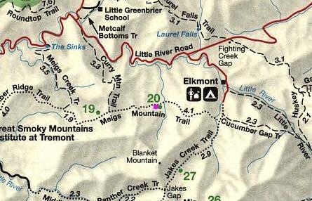
Avent Cabin Map
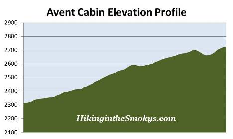
Avent Cabin Elevation Profile
Directions to Trailhead:
The hike to the Avent Cabin in the Great Smoky Mountains begins from the Jakes Creek Trailhead in Elkmont. To reach the trailhead from the Sugarlands Visitor Center near Gatlinburg, drive 4.9 miles west along the Little River Road to the turnoff for the Elkmont Campground, which will be on your left. After turning into Elkmont, drive 1.4 miles to reach the campground entrance. Instead of proceeding into the campground, turn left and drive another 0.8 miles to the parking area for the Jakes Creek Trailhead at the end of the road.
From the Townsend "Y" intersection near Cades Cove, the turnoff for the Elkmont Campground will be 12.6 miles away.