Baskins Creek Falls Highlights
- Trail Features
Waterfalls
- Trail Location
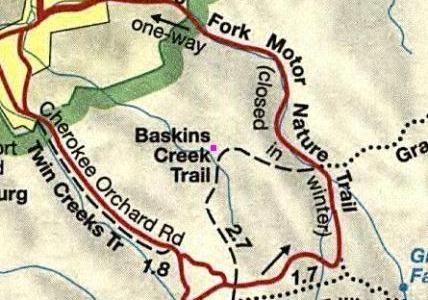
Roaring Fork Motor Nature Trail
- Roundtrip Length
3.0 Miles
- Elevation Gain (total)
953 Feet
- Elevation Gain (per mile)
635 Feet
- Trail Difficulty
4.91
Easy
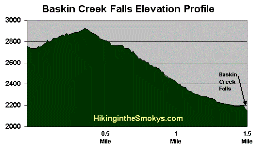
This easy hike is 3.0 miles roundtrip and includes 953 feet of elevation gain.
Baskins Creek Falls Description
The hike to Baskins Creek Falls, also known as Baskins Falls, begins with a short easy climb. At roughly one-quarter of a mile the terrain levels out where you'll have some decent views of the mountains towards the west, as well as a few glimpses of Gatlinburg - if you're hiking in the winter or early spring. These views, however, will more than likely be obstructed by summer foliage.
At 0.9 miles hikers will cross Falls Branch without the assistance of a footbridge. If hiking after a long hard rain this could present a little bit of a challenge, if your goal is to keep your feet dry. The trail then veers off to the left and begins following the creek down the mountain. This a fairly rapid descent, and will make for a challenging climb on your return trip.
At 1.1 miles a side trail will spur off to the left and lead towards the Baskins Cemetery. You should stay to the right to continue towards the falls.
Shortly thereafter the trail crosses over a small creek, but this time is a much easier crossing.
At 1.3 miles hikers will arrive at a trail junction. Continuing straight ahead here would lead you across Baskins Creek, and eventually over to the eastern side of the Roaring Fork Motor Nature Trail, roughly 1.3 miles from this point. To continue on towards the falls hikers should turn left at this junction.
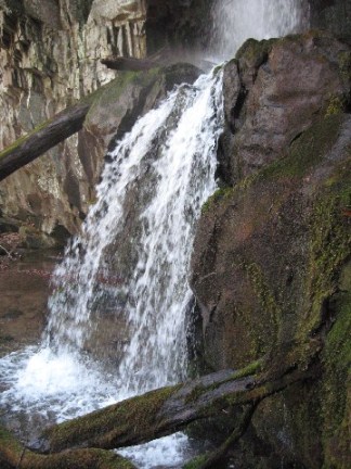
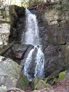
The last 50 yards or so down to Baskins Creek Falls is fairly steep and rugged, but well worth the effort. Relative to their popularity, this 40-foot, two-tiered waterfall just might be the most underrated waterfall hike in the Great Smoky Mountains. It's also a great place to kick back and enjoy a picnic lunch if desired.
The falls and the creek purportedly received their name from a local hunter known as Bearskin Joe, and over time, the pronunciation evolved into "Baskins".
Baskins Creek Falls Map
Baskins Creek Falls Elevation Profile
Directions to Trailhead:
The hike to Baskins Creek Falls in the Great Smoky Mountains begins from the Baskins Creek Trailhead just outside of Gatlinburg. Starting from Light 8 in Gatlinburg, turn onto Historic Nature Trail / Airport Road. After driving 0.7 miles veer right onto Cherokee Orchard Road, upon which you'll enter into Great Smoky Mountain National Park. After driving another 2.2 miles you'll enter the one-way Cherokee Orchard Loop. Drive 0.9 miles on this loop before turning right onto the Roaring Fork Motor Nature Trail. The trailhead for the falls will be on your left after driving roughly 0.2 miles on this one-way loop road.