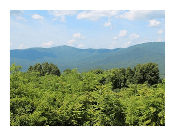
Cohutta / Big Frog Mountain Wilderness Areas
Just east of Chattanooga, along the Tennessee-Georgia border, resides some of the oldest known mountains in the world. Protecting these ancient peaks today is the Cohutta and Big Frog Mountain Wilderness Areas. The majority of the Big Frog Wilderness lies within Tennessee, while the largest portion of Cohutta resides in Georgia.
The combination of the Big Frog and the Cohutta Wilderness Areas, including adjacent primitive areas, creates the largest swathe of wilderness on Forest Service lands in the eastern U.S.
The district also contains the westernmost land in the eastern United States with an elevation higher than 4,000 feet. In fact, there is no higher point west of Big Frog Mountain until reaching Big Bend in Texas or the Black Hills of South Dakota.
Big Frog Mountain Wilderness
Big Frog was designated as a Wilderness Area in 1984, and currently consists of 8,132 acres. This beautiful remote area offers mountain vistas, waterfalls and clear mountain streams, and serves as a sanctuary for black bears.
The highest elevation in the Wilderness is the 4,224-foot Big Frog Mountain in Tennessee. Although not a high mountain in comparison to its eastern neighbors in the Smokies, Big Frog dominates the Wilderness because it stands alone above the surrounding terrain.
Hiking in Big Frog Mountain
The Big Frog Mountain Wilderness offers roughly 35 miles of backcountry trails, and provides many outstanding opportunities for backpacking, solitude, primitive camping, as well as some excellent opportunities for fishing.
The most popular trails are those that lead to the summit of Big Frog Mountain, including the Big Frog, Licklog Ridge and Wolf Ridge trails.
All trails within the wilderness are rated as moderately difficult. The trails listed below are in Forest Service number order. Mileage figures are one way distances:
Benton MacKaye FS #2 Long distance trail that extends for nearly 300 miles through the southern Appalachian Mountains. The trail runs from Springer Mountain in Georgia to Davenport Gap on the northern edge of the Great Smoky Mountains. For roughly 13 miles it passes through the eastern end of both the Big Frog and Cohutta Wilderness areas.
Conasauga River Trail #61 (5.1 miles) Trail follows a ridgeline for 2 miles before descending to the beautiful Conasauga River. From here the trail follows along an old railroad bed and continues deep into the Cohutta Wilderness area.
Chestnut Gap Trail #63 (1.9 miles) Also known as the Chestnut Mountain Trail, this path climbs a ridge that offers several scenic vantage points before ending at the Wolf Ridge Trail junction.
Big Frog Trail / Benton MacKaye #64 (5.5 miles) Leads to panoramic views at the top of Big Frog Mountain. The trail gains about 2000 feet of elevation.
Licklog Ridge #65 (5.9 miles) Leads to panoramic views at the top of Big Frog Mountain. Although the trail gains roughly 2500 feet, the ascents are gradual.
Wolf Ridge Trail #66 (4.5 miles) Hike offers outstanding mountain views. Wolf Ridge is the shortest and most difficult trail to the top of Big Frog Mountain. It gains roughly 2,500 feet.
Grassy Gap #67 (3.5 miles) Also known as Barkleggin Trail, this hike offers seclusion as it meanders through the wilderness. The trail ends at the intersection of the Yellow Stand Lead and Big Frog trails.
Big Creek Trail #68 (5.6 miles) Popular camping area along trail.
Fork Ridge / Benton MacKaye #69 (1.9 miles) Connector trail between the Rough Creek and Big Frog trails.
Rough Creek / Benton MacKaye #70 (2.9 miles) Connector trail for the Big Frog, Licklog and the East Fork Ridge trails.
West Fork / Benton MacKaye #303 (3.9 miles) Wildflowers are abundant on this trail during the spring. There are several stream crossings that hikers should be aware of.
Yellow Stand Lead #73 (2.9 miles) Hikers will enjoy several mountain views along this hike, as well as a few good fishing holes.
Hemp Top #145 (0.8 miles) The Hemp Top Trail begins off the Licklog Ridge Trail and leads southeast to Double Spring Gap before proceeding into Georgia.
Cohutta Wilderness
The area that became the Cohutta Wilderness was once owned, railroaded, and intensively logged by lumber companies. In the 1920's the U.S. Government purchased these lands and began intensive work to restore and protect the forests and watersheds. In 1975 the U.S. Congress passed legislation that added Cohutta to the National Wilderness Preservation System. Now encompassing 37,030 acres, Cohutta is the largest National Forest Wilderness in the southeast, and with more than 60,000 visitors each year, is the largest, most heavily used wilderness in the Southern Appalachians.
 The headwaters of the Conasauga River are located within the Wilderness. From a mountain spring the river begins as a small cold stream, and proceeds to flow northward into Tennessee. Both the Conasauga and Jacks Rivers, two of the state's most famous trout streams, plunge through rocky gorges, and during periods of heavy rain, create flash floods on the Wilderness.
The name Cohutta is a Cherokee word that may mean "frog". The word could also be interpreted to mean "a shed roof supported on poles".
Hiking in the Cohutta Wilderness
With 95 miles of trails, the Cohutta Wilderness is a hiker's paradise. Many of the most popular trails follow either the Conasauga or Jacks River, and at least a dozen others provide access to the Wilderness. Many of the trails require wading through streams. The 15.7-mile Jacks River Trail, for instance, fords the river at least 42 times.
After heavy rains both the Jacks and Conasauga rivers can become raging torrents, and are virtually impossible to cross safely. Those planning a hike here should carefully check the weather forecast beforehand. You may want to bring trekking poles to help with river crossings. If the waters are turbulent, don't attempt to cross or even wade into these streams.
Even in low water hikers should plan on getting wet. The Conasauga River Trail alone has 38 stream crossings between Betty Gap and Forest Service Road 17. Obviously, hiking boots will quickly become soaked in these conditions. As a result, many hikers simply wear old tennis shoes and resign themselves to having wet feet on many of these hikes. If you're backpacking, you'll definitely want to bring dry shoes for walking around camp.
Beech Bottom Trail (4 miles) An easy to moderately difficult access trail to Jacks River and Jacks River Falls. It's also the only trail that leads to Jacks River Falls without fording the river. As a result, the Beech Bottom Trail is the most popular trail in the Cohutta Wilderness.
Chestnut Lead Trail (.14 mile) An easy hike that provides an up-close look at the remains of the giant chestnut trees that once thrived in this forest before the chestnut blight.
Conasauga River Trail (13.1 miles) Marked by yellow blazes, this is a moderately difficult trail that crosses the river 38 times. Large eastern hemlocks are one of features of this trail, which utilizes an old railroad bed. Bray Field, an old logging camp, is now a popular and sometimes crowded camping area, located near the Hickory Creek Trail junction.
East Cowpen Trail (7 miles) This moderately strenuous trail follows the former route of Old Highway 2. Although it's not a destination trail, it does provide relatively quick access to other trails and destinations in the Wilderness.
Hemp Top Trail (6.2 miles) A moderately difficult to strenuous trail that travels into the Big Frog Wilderness in Tennessee. This lesser-used trail can also be used to climb Big Frog Mountain.
Hickory Creek Trail (8.6 miles) An easy to moderately difficult trail that offers access to the Conasauga River, which can be reached from either end of this trail. From its western trailhead, the river is roughly 1.5 miles away.
Hickory Ridge Trail (3.6 miles) A moderately strenuous hike that leads to Jacks River and Jacks River Falls.
Jacks River Trail (16.7 miles) This moderately difficult trail travels along an old railroad bed. It crosses the river 42 times, making it the longest and wettest trail in the Wilderness, and is often crowded at Jacks River Falls. The least-used portion of the trail is from Alaculsy to Jacks River Falls. Backpackers may want to note that there are several outstanding places to camp at Horseshoe Bend.
Panther Creek Trail (3.4 miles) Although moderately difficult to strenuous, with some very rugged and rocky sections, this is still a very popular and scenic trail that passes a high waterfall.
Penitentiary Branch Trail (3.6 miles) An easy to moderately difficult trail that starts along the Hemp Top Trail and ends at Jacks River.
Rice Camp Trail (3.9 miles) An easy to moderately difficult hike to Jacks River. Includes several stream crossings.
Rough Ridge Trail (7 miles) Another moderately difficult to strenuous hike that provides access to Jacks River.
Sugar Cove Trail (2.2 miles) A moderately difficult to strenuous trail that leads down to Jacks River. The trail descends through a hardwood cove forest.
Tearbritches Trail (3.2 miles) A moderately difficult to strenuous trail that climbs 4005-foot Bald Mountain, before descending steeply back down to Bray Field, at the junction for the Conasauga River and Hickory Creek trails.
Key Links:
Benton MacKaye Trail Association