Big South Fork National River and Recreation Area
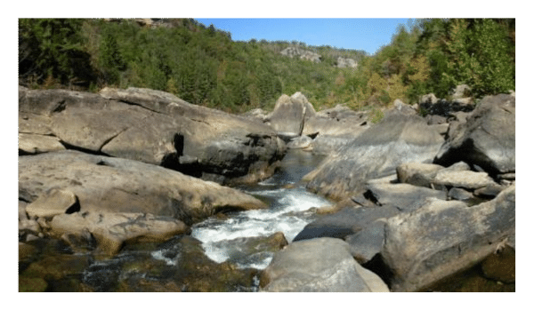
Established in 1974, the Big South Fork National River and Recreation Area encompasses roughly 125,000 acres in some of the most rugged terrain of the Cumberland Plateau. It's located in north central Tennessee and southeastern Kentucky, and protects the free-flowing Big South Fork of the Cumberland River and its tributaries.
The area boasts miles of scenic gorges and sandstone bluffs, is rich with natural and historic features, and provides visitors with a wide range of outdoor recreational activities.
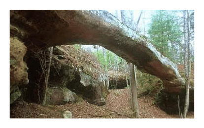 Over the eons water flowing into the Cumberland River has carved the plateau's sandstone into impressive cliffs, arches and chimneys. As a result, the Big South Fork contains one of the highest concentrations of natural bridges in the eastern United States. Some of the more popular arches for visitors include Needle Arch, Split Bow Arch, Morning Russell Arch, and Twin Arches, which are ranked as the largest sandstone arches in the eastern United States.
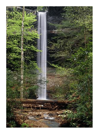
Big South Fork is also home to the highest waterfall in the state of Kentucky. A short half-mile hike leads to Yahoo Falls, which drops 113 feet.
Some of the larger mammals found in the area include black bears, white-tailed deer, bobcats, gray fox and elk, which migrated into the area from nearby state managed lands.
The Big South Fork is also the home of the Charit Creek Lodge, which is owned by the same people who own the Mt. LeConte Lodge in Great Smoky Mountains National Park. Similar to the Mt. LeConte Lodge, the Charit Creek Lodge is located deep in the Big South Fork National River and Recreation Area, and is only accessible by horseback, foot or mountain bike. With many interconnecting trails, the lodge presents several opportunities for extended hikes while not having to sleep in a tent at the end of the day.
In addition to the lodge, the park offers camping, hiking, backpacking, horseback riding, mountain biking, rafting, canoeing, kayaking, tubing, hunting and fishing. On a clear night, and with roughly 2000 stars visible with the naked eye, the Big South Fork is also an excellent place for night sky-watching.
Hiking in the Big South Fork
There are roughly 150 miles of marked hiking trails in the Big South Fork. Some of the most popular hikes include Twin Arches, Slave Falls/Needle Arch, Sunset Overlook, Angel Falls Rapids, Bear Creek Overlook, and the Yahoo Falls Loop.
 Kentucky Trails:
Blue Heron Loop (6.5 miles RT) Moderate to difficult hike with several scenic overlooks. The trail visits the Blue Heron Mining Camp and its extensive exhibits. It also goes through a natural opening in the cliff known as "Cracks in the Rocks".
Yahoo Falls Loop (1 mile RT) Moderate hike to 113-foot waterfalls - the highest falls in Kentucky.
Split Bow Arch (1.3 miles RT) Easy hike to arch.
Bear Creek Overlook (0.5 miles RT) Easy hike to a panoramic river overlook.
Catawba Overlook (3.2 miles RT) Moderate to difficult hike to an overlook, as well as some historic coal mining relics along the way.
Tennessee Trails:
Honey Creek/Burnt Mill Bridge Area
Honey Creek Loop (5.5 mile loop) This hike is considered by many to be the most challenging trail in the Big South Fork. Some of the many hazards hikers can encounter include steep narrow sections, numerous creek crossings, slick boulders, and confusing trail junctions. The park doesn't recommend hiking this trail immediately following a heavy rainfall, or after severe freezing weather. Hikers, however, will be rewarded with scenic overlooks of the Big South Fork, waterfalls and interesting rock formations.
Burnt Mill Loop (3.6 mile loop) Trail parallels the Clear Fork River for most of the way.
Gentlemen's Swimming Hole (0.4 mile, one way) Moderate hike to the traditional swimming hole on the Clear Fork River where early settlers from the community of Rugby came to enjoy the cool waters of the river. Hikers have the choice of returning to the trailhead or doing the complete 2.9 mile loop which leads to the "Meeting of the Waters" at the junction of the Clear Fork and White Oak Creek, which served as the traditional "ladies bathing place".
Divided Road Area
Twin Arches (0.7 miles, one way) The most direct route to the base of North Arch.
Twin Arches Loop (6.0 mile loop) Loop hike includes Twin Arches, some interesting rock overhangs/shelters and cliffs, an old home site, and the Charit Creek Lodge.
Middle Creek Loop (3.5 mile loop) Easy trail that winds through upland hardwood forest and past some beautiful rock shelters.
Laurel Fork (13.1 miles, one way) Trail leads to a few rock shelters and includes numerous creek crossings. The trail ends at the junction with the John Muir Trail.
Slave Falls/Needles Arch (3.0 miles RT) This short, easy hike includes a good view of a 60-foot waterfall as well as Needles Arch.
Slave Falls Loop (3.2 mile loop) Hike includes Slave Falls and Needles Arch.
Rock Creek Loop (7.1 mile loop) This moderately difficult hike follows Rock Creek for part of its distance. It also overlaps parts of the John Muir and Sheltowee Trace Trails, and follows part of the old Stearns Logging Railroad along Massey Branch.
Brandy Creek Area
Oscar Blevins Loop (3.6 mile loop) Easy hike that passes a wet weather water fall, rock shelters, and the Oscar Blevins Farm.
Bandy Creek Campground Loop (1.3 mile loop) Easy hike through upland forest.
Litton/Slaven Farm Loop (5.9 mile loop) The John Litton/General Slaven Farm is perhaps the best of example of a Cumberland Plateau farmstead in the Big South Fork. Even today it has a remote, isolated feeling about it. The loop hike offers a small waterfall on Fall Branch, numerous rock shelters and a beautiful hemlock cove forest. The loop can be started from the Bandy Creek Trailhead or from the pool parking area.
Bandy Creek to Angel Falls Overlook (10 miles RT) Moderately difficult hike to overlook in the Leatherwood Ford area.
Leatherwood Ford Area
Angel Falls Rapids (4.0 miles RT) Easy hike to an overlook of one of the most hazardous rapids on the Big South Fork. Includes outstanding views of the river and the high cliffs.
Angel Falls Overlook (5.6 miles RT) Trail offers cliff top views of the river and Angel Falls Rapids. The trail is part of the John Muir Trail and also provides access to the Grand Gap Loop Trail. Hiking the Grand Gap Loop is a 12.4 mile RT hike.
Leatherwood Loop (3.2 miles RT) Moderately strenuous hike that features an overlook, while offering a variety of scenery along the way.
O & W Railroad Bridge (4.6 miles RT) Moderate hike to an old railroad trestle built in 1915.
Sunset Overlook (2.6 miles RT) Hike to outstanding view of the Big South Fork.
Long Distance Trails
John Muir Trail: The John Muir Trail begins at the O.W. Railroad Bridge and winds 44 miles through the Big South Fork National River & Recreation Area. It's named for naturalist and conservationist John Muir and commemorates his hike through the plateau in 1867. When completed, the John Muir Trail will extend from Pickett State Park on the Cumberland Plateau to the Appalachian Trail in the southern part of the Cherokee National Forest. Please note that finding water in the dry months can be a problem.
Sheltowee Trace National Recreation Trail: The 282-mile Sheltowee Trace enters the Big South Fork near Yahoo Falls, follows the river for eight miles before returning to the Daniel Boone National Forest. The trail is named in honor of Daniel Boone. Sheltowee (meaning Big Turtle) was the name given to Boone when he was adopted into the Shawnee Indian tribe as the son of the great war chief, Blackfish. The trail traverses the length of the Daniel Boone National Forest.
Key Links:
Big South Fork National River & Recreation Area
Big South Fork Hiking Information
Big South Fork Landforms (Waypoints for arches, waterfalls, etc.)