Blue Ridge Parkway
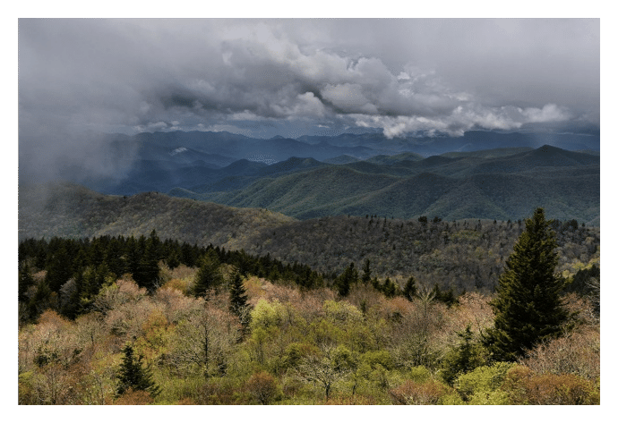
Considered by many to be "America's Favorite Drive", the Blue Ridge Parkway stretches 469 miles along the crest of the Blue Ridge Mountains of North Carolina and Virginia, while connecting Shenandoah National Park to Great Smoky Mountains National Park. It provides travelers with spectacular views of mountains and valleys, quiet pastoral settings, numerous waterfalls, and magnificent "gardens" of flowering plants.
The Blue Ridge Parkway is the longest road planned as a single unit in the United States. Protecting significant mountain landscapes far beyond the shoulders of the road itself, the park encompasses more than 93,000 acres. It also contains some of the oldest settlements from both pre-historic natives and early-European settlers.
The Blue Ridge Parkway travels through terrain that comprises a wide variety of natural ecosystems. Along the route is an unsurpassed diversity of climate zones, vegetation zones, physiographic zones and many interesting geological features. With its elevation ranging between 650 and 6,053 feet, the Parkway provides a home for both northern and southern species. Parkway lands also protect pine, hardwood and spruce-fir forests, mountains, a variety of wetland types, over 600 streams (including 150 headwaters), and 47 Natural Heritage Areas.
Seventy-four different mammals, more than 50 salamanders, and 35 reptiles can be found within the park. Bears, cougars, bobcats, gray and red fox, otter, deer, beaver and wild boar are among the many animals that can be found on Parkway lands. 159 species of birds are known to nest here, with dozens of others passing through during the fall and spring migrations. Travelers may see hawks, falcons, ducks and herons in the mountains, streams and lakes of the national park.
Travelers can count more than 130 species of trees along the Parkway, roughly the same number that can be found in all of Europe.
As a result of all of this it should come as no surprise that the Blue Ridge Parkway is the most heavily visited unit in the entire National Park System. It attracts roughly 15 to 20 million visitors each year!
Brief History:
It was the construction of Skyline Drive through Shenandoah National Park that provided the inspiration for the creation of the Blue Ridge Parkway. When President Franklin Roosevelt visited Shenandoah in 1933, Virginia Senator Harry Flood Byrd suggested that the roadway be extended all the way to the new Great Smoky Mountains National Park. Roosevelt eagerly supported this idea, and on November 24, 1933, Interior Secretary Harold Ickes approved plans for the construction of the new "Park-to-Park Highway" as a public works project.
Originally called the "Appalachian Scenic Highway," construction began on a 12.5-mile section near Cumberland Knob in North Carolina on September 11, 1935. Work in Virginia wouldn't begin until the following February. The Parkway wasn't constructed as one continuous project, but instead was divided into 45 separate units. This approach was required, in large part, due to numerous land acquisition delays. Additionally, since this was in the middle of the Great Depression, segmentation also allowed Parkway contractors to hire more people to work simultaneously.
By 1966 the Blue Ridge Parkway was more than 95% complete. However, it would take another 21 years before the final 7.7-mile "missing link" would be completed at Grandfather Mountain in North Carolina.
In the 1970s the Park Service finally agreed upon a route that would minimize damage to the rugged terrain on Grandfather Mountain. A key feature of this section was the revolutionary Linn Cove Viaduct, which was finally completed in 1987, thus opening the entire length of the Parkway to the public for the very first time. The quarter-mile long viaduct has since won 12 national design awards, and is considered by many to be the most popular section of the Parkway.
Hiking along the Blue Ridge Parkway
Hiking, cycling, horseback riding, bird watching, fishing, photography and camping are among the most popular outdoor pursuits for visitors on the Blue Ridge Parkway.
The Parkway offers over a hundred hiking trails along its route. Some of the most popular trails include Abbott Lake Trail (Milepost 85.7), Sharp Top Trail (86.0), Mountain Industry Trail, which leads to Mabry Mill (176.2), Rough Ridge (303.0), Beacon Heights Trail (305.2), Linville Falls Trail (316.4), Crabtree Falls Loop Trail (339.5), Craggy Pinnacle Trail (364.2), Graveyard Fields Loop Trail (418.8), Black Balsam Knob (420.2) and the Waterrock Knob Trail (451.2).
Below is a list of 119 hikes with quick and easy reference information. Starting from the north in Virginia and moving south through North Carolina, each hike listed includes its location point based on its Milepost, trail name, a brief description, and one-way mileage (unless otherwise noted).
5.9 Mountain Farm Trail (to pioneer farmstead) 0.25
6.0 Appalachian Trail (to Humpback Mountain, elevation, 3650 feet) 2.0
8.4 Catoctin Loop Trail 0.3
8.8 Greenstone Trail (Greenstone geology formation) 0.2
17.6 The Priest (view) 0.1
18.5 White Rock Falls Trail Connection 2.9
20.0 White Rock Falls Trail (follows stream to small falls) 0.9
26.3 Big Spy Mountain (view into Shenandoah Valley) 0.134.4 Yankee Horse (to logging RR exhibit & small waterfall) 0.238.8 Boston Knob 0.1
47.5 Indian Gap (to Indian Rocks) 0.3
55.2 White Oak Flats 0.1
60.8 Otter Creek Trail 3.5
63.1 Otter Lake Trail (around Otter Lake) 0.8
63.6 James River Trail (Self-guiding to canal locks) 0.2
63.6 Trail of Trees Trail (to James River Overlook) 0.5
74.7 Thunder Ridge Trail (loop trail to view of Arnold Valley) 0.1
78.4 Apple Orchard Falls Trail (National Recreation Trail) 1.2
79.7 Onion Mountain Loop Trail 0.1
83.1 Fallingwater Cascades Trail (National Recreation Trail; loop to view of cascades) 1.6
83.5 Flat Top Trail (leads to highest of three prominent peaks in area) 4.4
83.5 Cross Rock Trail (spur off Flat Top Trail; unique geological features) 0.1
85.7 Abbott Lake Trail (loop around Abbott Lake) 1.0
85.9 Elk Run Trail (self-guiding loop nature trail from Visitor Center) 0.8
85.9 Johnson Farm Loop Trail (loop to restored mountain farm) 2.1
85.9 Harkening Hill Trail 3.3
85.9 Balance Rock (spur trail off Harkening Hill Trail with unique geological formations) 0.1
86.0 Sharp Top Trail (to summit of Sharp Top Mtn. with 360 degree panoramic views) 1.5
91.0 Appalachian Trail (to Sharp Top Mtn. Overlook) 1.9
92.5 Appalachian Trail (Sharp Top Mtn. Overlook to Harvey's Knob Overlook) 2.9
95.4 Appalachian Trail (Harvey's Knob Overlook to Motvale Overlook) 0.6
95.9 Appalachian Trail (Montvale Overlook to Taylor's Mountain Overlook) 1.0
96.0 Spec Mine Trail 2.8
97.0 Appalachian Trail (Taylor's Mtn. Overlook to Blackhorse Gap) 0.8
110.6 Stewarts Knob Trail (summit view) 0.05
114.9 Roanoke River Trail (self-guiding river loop) 0.35
120.4 Roanoke Mountain Summit Trail (summit view) 0.11
120.5 Chestnut Ridge Trail (adjacent to Roanoke Mtn. campground) 1.75
121.4 Roanoke Valley Horse Trail (parallels Parkway to Milepost 110.6) 18.5
123.2 Buck Mountain Trail (to summit view) 0.53
154.5 Smart View Loop Trail (around picnic area) 2.6
167.1 Rock Castle Gorge Trail (loop hike along ridge over Rocky Knob and into gorge) 10.8
167.1 Hardwood Cove Self-Guiding Nature Trail (part of Rock Castle Loop) 0.8
169.0 Black Ridge Trail (trail leads to Black Ridge and Grassy Knoll) 3.1
169.0 Rocky Knob Picnic Loop Trail (leg stretcher around picnic area) 1.0
176.2 Mountain Industry Trail (leads to historic Mabry Mill) 0.5
179.2 Round Meadow Creek Loop Trail (walk along stream bottom forest) 0.5
217.5 Cumberland Knob Trail 0.5
217.5 Gully Creek Trail (meandering loop near stream) 2.0
218.6 Fox Hunters Paradise Trail (view) 0.2
230.1 Little Glade Millpons (easy loop stroll around pond) 0.4
238.5 Cedar Ridge Trail (vistas and forests) 4.2
238.5 Bluff Mountain Trail (parallels Parkway to Milepost 244.7) 7.5241.0 Fodder Stack Trail (see variety of plants) 1.0241.0 Bluff Ridge Trail (primitive trail with steep slopes) 2.9
243.7 Grassy Gap Fire Road 6.5
243.7 Basin Creek Trail 3.3
244.7 Flat Rock Ridge Trail (forest path with vistas) 5.0
260.3 Jumpingoff Rocks Trail (forest path to vista) 1.0
264.4 The Lump Trail (to hilltop view) 0.3
271.9 Cascades Trail (self-guiding loop to view of falls) 0.5
272.5 Tompkins Knob Trail (to Jesse Brown Cabin) 0.6
294.0 Rich Mountain Carriage, Horse, & Hiking Trail 3.0
294.0 Flat Top Mountain Carriage, Horse, & Hiking Trail 3.0
294.0 Watkins Carriage, Horse & Hiking Trail 3.3
294.0 Black Bottom Carriage, Horse, & Hiking Trail 0.5
294.0 Bass Lake Carriage, Horse & Hiking Trail 1.7
294.0 Deer Park Carriage, Horse, & Hiking Trail 0.8
294.0 Maze Carriage, Horse, & Hiking Trail 2.3
294.0 Duncan Carriage, Horse, & Hiking Trail 2.5
294.0 Rock Creek Bridge Carriage, Horse, & Hiking Trail 1
294.1 Figure 8 Trail (short self-guiding loop nature trail) 0.7
294.6 Trout Lake Hiking & Horse Trail (loop) 1
295.9 Green Knob Trail (to Green Knob) 2.3
296.5 Boone Fork Trail (stream, forest, and meadows) 4.9
297.0 Price Lake Loop Trail (loop around Price Lake) 2.3
304.4 Linn Cove Viaduct Access Trail 0.16
303.0 Rough Ridge (spectacular views of Grandfather Mtn & Linn Cove Viaduct) 1.0
305.2 Beacon Heights Trail (leads to view) 0.25
305.5 Tanawha Trail (diverse biological and geological features) 13.5
308.2 Flat Rock Trail (self-guided loop) 0.63
315.5 Camp Creek Trail 0.1
316.4 Linville Falls Trail (view of upper Falls) 0.8
316.4 Linville Gorge Trail (view of lower Falls) 0.5
316.4 Duggers Creek Trail (loop to view of Duggers Falls) 0.25
316.5 Linville River Bridge Trail (leg stretcher to view of unusual bridge) 0.1
320.8 Chestoa View Trail (loop hike to vista) 0.63
339.5 Crabtree Falls Loop Trail (loop to beautiful 70-foot waterfall) 2.0
344.1 Woods Mountain Trail 2.0
350.4 Lost Cove Ridge Trail 0.6
351.9 Deep Gap Trail 0.2
355.0 Bald Knob Ridge Trail 0.1
359.8 Big Butt Trail 0.2
361.2 Glassmine Falls (view of falls) 0.05
364.2 Craggy Pinnacle Trail (to panoramic view) 0.73
364.2 Craggy Gardens Trail (first portion is self-guiding nature trail) 0.84
374.4 Rattlesnake Lodge Trail (woodland walk) 0.5
382.0 Mountain-to-Sea Trail (spring wildflowers and views; parallels parkway) 7.5
393.7 Shut-In Trail/MTS Trail (Bent Creek-Walnut Cove) 3.1
396.4 Shut-In Trail/MTS Trail (Walnut Cove-Sleepy Gap) 1.7
397.3 Grassy Knob Trail (steep trail to USFS area) 0.9
397.3 Shut-In Trail/MTS Trail (Sleepy Gap-Chestnut Cove) 0.7
398.3 Shut-In Trail/MTS Trail (Chestnut Cove-Bent Creek Gap) 2.8
400.3 Shut-In Trail/MTS Trail (Bent Creek Gap-Beaver Dam Gap) 1.9
401.7 Shut-In Trail/MTS Trail (Beaver Dam Gap-Stoney Bald) 0.9
402.6 Shut-In Trail/MTS Trail (Stoney Bald-Big Ridge) 1.2
403.6 Shut-In Trail/MTS Trail (Big Ridge-Mills River Valley) 1.2
404.5 Shut-In Trail/MTS Trail (Mills River Valley-Elk Pasture Gap) 1.2
405.5 Shut-In Trail/MTS Trail (Elk Pasture Gap-Mt. Pisgah) 1.7
407.6 Mt. Pisgah Trail (summit view) 1.25
407.6 Buck Springs Trail (Pisgah Lodge to view) 1.1
408.5 Frying Pan Mountain Trail 1.65
417.0 East Fork Trail (access to Shining Rock Trail System) 0.1
418.8 Graveyard Fields Loop Trail (loop passes two waterfalls) 2.3
419.4 John Rock Trail (leads to view) 0.1
420.2 Black Balsam Knob (take Art Loeb Trail to spectacular mountain bald) 2.0
422.4 Devil's Courthouse Trail (panoramic summit view) 0.42
427.6 Bear Pen Gap Trail (access to Mountains-to-Sea Trail) 0.22
431.0 Richland Balsam Trail (loop through spruce-fir forest) 1.5
433.8 Toy Taylor Overlook Trail (paved trail to overlook) 0.1
451.2 Waterrock Knob Trail (summit view) 1.2
Key Links:
Blue Ridge Parkway NPS Website