Boogerman Loop Highlights
- Trail Features
History, Old Growth Forest, Streams
- Trail Location
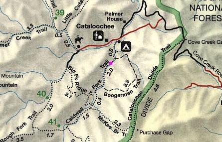
Cataloochee
- Roundtrip Length
7.4 Miles
- Elevation Gain (total)
1040 Feet
- Elevation Gain (per mile)
281 Feet
- Trail Difficulty
9.48
Moderately Difficult
This moderately difficult hike is 7.4 miles roundtrip and includes 1040 feet of elevation gain.
Boogerman Loop Description
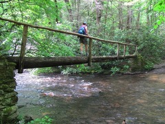
The Boogerman Loop hike begins from the Caldwell Fork Trailhead, whereupon it immediately crosses over one of the longest footbridges in the Park.
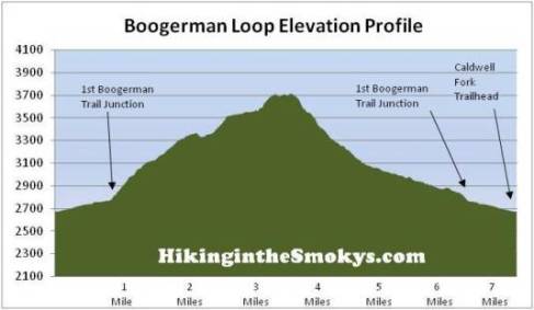
At just over eight-tenths of a mile hikers will reach the first Boogerman Trail junction. To follow this trail description, turn left onto the Boogerman Trail here.
The trail receives its name from Robert Palmer, whose nickname was "Boogerman." Legend has it that on Palmer's first day of school the teacher asked him what he wanted to be when he grew up. Palmer replied "the Boogerman," and the name would stick into adulthood.
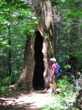
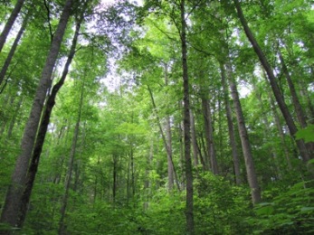
Once on the Boogerman Trail it will become quite apparent that you're hiking in an old growth forest. You'll pass several very large trees, including white pines, yellow-poplars, as well as eastern hemlocks - including many that are dead and dying - victims of the hemlock wooly adelgid infestation.
Fortunately for us modern day visitors Robert Palmer was very protective of his forest. He rejected all buy-out offers from lumber companies to harvest the wood on his property. As a result, some of the tallest trees in the Cataloochee Valley are found along this section of the Boogerman Trail. According to the Volume 2 #1 issue of Smokies Life Magazine, the Cataloochee Valley is home to three eastern hemlocks that stand more than 170 feet in height.
Hikers will pass the former Palmer home site at roughly the 2.3-mile mark. At roughly 3 miles from the trailhead there used to be an old wagon wheel sitting against a tree on your right. I'm not sure if it's still there or not, but we obviously missed it.
Other than the initial climb, and another short stiff climb near the half-way point, the Boogerman Trail is a very pleasant walk in the woods.
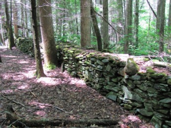
At just over 4 miles from the trailhead you'll come to a very impressive rock wall - roughly 70 or 80 feet in length, maybe 3 feet in height, and more than 2 feet in width. These are some of the remnants from the old Carson Messer homestead. As you proceed further down the hill you'll pass a few other stone walls along the way.
Upon reaching the old Messer homestead the trail begins to follow a small creek known as the Snake Branch, which you'll cross over several times without the benefit of a bridge.
At roughly 4.7 miles you'll reach the Caldwell Fork Trail once again. Hikers should turn right at this junction to continue on the loop hike.
From here the trail follows the Caldwell Fork of Cataloochee Creek all the way back to the trailhead. In fact, you'll cross Caldwell Fork at least a dozen times. There are a couple of trail junctions that you might find a little confusing. Branching off the main trail in these instances are side trails that allow horses to ford the creek. You may also want to note that as a result of horse traffic, this trail can be quite muddy at times.
About a third-of-a-mile from the junction you'll reach a section of trail where the path seems to disappear. Just follow the creek bed for about 50 feet or so and you'll easily pick-up the trail again on the left side of the creek.
At roughly 6.5 miles you'll finally reach the first junction with the Boogerman Trail once again. The trailhead is less than a mile away from this point
Boogerman Loop Map
Boogerman Loop Elevation Profile
Directions to Trailhead:
From Exit 20 off I-40 in North Carolina, almost immediately after turning onto Rt. 276, turn right to head west on Cove Creek Road. Roughly 4.7 miles from the turn-off the paved road ends and you'll begin driving on a gravel/dirt road. The road is passable for low clearance, two-wheel drive passenger cars; however, you should expect some rough, washboard sections. You'll just have to drive slowly.
At 5.9 miles you'll reach the national park entrance gate, and at 7.6 miles you'll arrive at the paved turn-off to Cataloochee. Turn left at this junction. At 10.7 miles you'll pass the Cataloochee Campground. Just past the campground, on the left, is the trailhead for the Caldwell Fork Trail which leads to the Boogerman Trail.