Brushy Mountain (via Trillium Gap Trail) Highlights
- Trail Features
Views, Waterfalls, Wildflowers
- Trail Location
Roaring Fork Motor Nature Trail
- Roundtrip Length
6.8 Miles
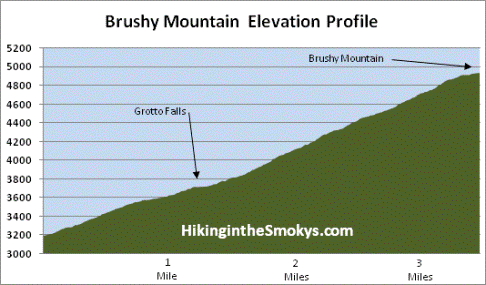
- Elevation Gain (total)
1745 Feet
- Elevation Gain (per mile)
513 Feet
- Trail Difficulty
10.29
Strenuous
This strenuous hike is 6.8 miles roundtrip and includes 1745 feet of elevation gain.
Brushy Mountain (via Trillium Gap Trail) Description
From the Trillium Gap Trailhead hikers will follow the Trillium Gap Trail for the majority of the route to Brushy Mountain. Along the way the footpath meanders through a beautiful old-growth forest, including many large eastern hemlocks.
The first section of trail is technically an access trail. At 0.15 miles you'll link up with the Trillium Gap Trail. Hikers should proceed straight ahead at this junction.
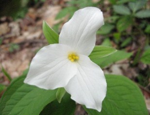
If you have the opportunity to hike this trail during the spring you'll likely witness a smorgasbord of wildflowers along the way. Look for white and yellow trillium, white violets, stitchwort, squawcorn and Dutchman's breeches that are common in this area.
For the most part the trail to Grotto Falls is a gentle climb along a wide, well-worn path. As you proceed to the waterfall you'll cross over four small streams without the assistance of a footbridge.
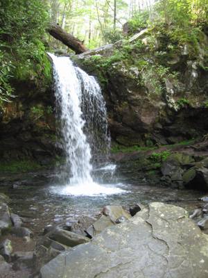
At 1.2 miles hikers will reach a tumbling cascade. Just beyond this point, looking upstream, Grotto Falls will come into view for the first time.
The most distinctive feature about Grotto Falls is that it's the only waterfall in Great Smoky Mountains National Park that a person can actually walk behind. The 25-foot high waterfall offers a cool, shady, and moist retreat for hikers in the summer. This same environment also provides ideal habitat for salamanders as well.
As you walk behind the falls you'll not only hear, but also feel the thunderous power of the water plunging into the pool in front of you. Watch your step here - especially in the winter - as the area surrounding the falls is perpetually wet and slick.
To reach Brushy Mountain hikers should continue beyond the falls. Roughly a quarter-of-a-mile above the falls you'll have your first view of the mountain, looking due east through the trees, and will continue to have intermittent views of your destination for the next half-mile or so.
At just over 3 miles hikers will reach Trillium Gap, where the path meets the Brushy Mountain Trail coming up from Porters Creek. To reach the summit of Brushy Mountain make sure to turn left at this junction. A turn to the right will lead you to the summit of Mt. LeConte.
Although the sign at the junction says that it's only two-tenths of a mile to Brushy Mountain, it's actually about a third-of-a-mile to the summit.
The last push to the summit is a gentle climb through a tunnel of rhododendron, mountain laurel, sand myrtle and other heath family shrubs and bushes. We also saw several painted trillium along this section as well.
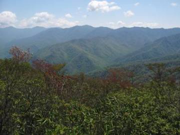
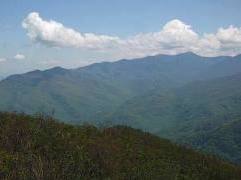
You'll know you've reached the summit when you reach a small semi-circular clearing. Looking towards the southeast this spot offers outstanding views of the entire eastern flank of the Great Smoky Mountains. Hikers will be able to see Charlies Bunion, Mount Sequoyah, Mount Chapman, Mount Guyot and beyond. Mount LeConte will be the dominating feature looking towards the south.
Make sure to continue on the trail for a short distance, roughly 50 feet or so, to reach another vantage point. This spot provides spectacular views of Webb Mountain, the Greenbrier valley and Pigeon Forge towards the north.
Hikers should note that the Roaring Fork Motor Nature Trail is closed during the winter (from December through mid-March). However, you can still reach Brushy Mountain by starting your hike from the Rainbow Falls Trailhead, located off Cherokee Orchard Loop Road. This will add another 3.4 miles to your roundtrip hike. You'll also have the option of reaching the summit from the trailhead in Greenbrier.
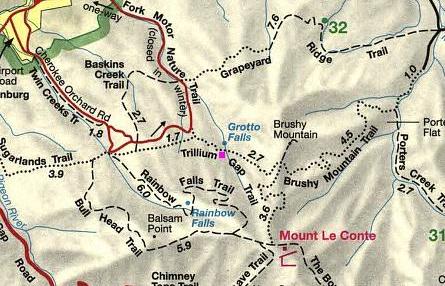
Brushy Mountain (via Trillium Gap Trail) Map
Brushy Mountain (via Trillium Gap Trail) Elevation Profile
Directions to Trailhead:
This hike to Brushy Mountain in the Great Smoky Mountains begins from the Trillium Gap Trailhead, located just outside of Gatlinburg. Starting from Light 8 in Gatlinburg, turn onto Historic Nature Trail / Airport Road. After driving 0.7 miles veer right onto Cherokee Orchard Road, upon which you'll enter into Great Smoky Mountain National Park. After driving another 2.2 miles you'll enter the one-way Cherokee Orchard Loop Road. Drive 0.9 miles on the loop before turning right onto the Roaring Fork Motor Nature Trail. The parking area for the trailhead will be on the left side of the road after driving roughly 1.6 miles along this one-way road. The trailhead is located just beyond the parking area on the opposite side of the road. Due to the popularity of this trail, there are additional parking spaces further up the road. Your best bet is to arrive early during the peak visitor season.