Brushy Mountain Trail Highlights
- Trail Features
Outstanding Views, History, Wildflowers
- Trail Location
Greenbrier
- Roundtrip Length
11.7 Miles
- Elevation Gain (total)
3000 Feet
- Elevation Gain (per mile)
513 Feet
- Trail Difficulty
17.70
Strenuous
This strenuous hike is 11.7 miles roundtrip and includes 3000 feet of elevation gain.
Brushy Mountain Trail Description
The first mile of this hike to Brushy Mountain follows the Porters Creek Trail, which is actually an old gravel road along this stretch of trail. The path meanders through a lush forest of moss covered trees and rocks as it follows along the banks of Porters Creek. If you have the opportunity to hike this trail during the spring you'll likely be treated to an awesome display of yellow trillium near the trailhead.
Roughly two-thirds of a mile from the trailhead several old stone walls will appear on your right. These are remnants from the Elbert Cantrell farmstead, who settled in the Porters Creek community in the early 1900s. Also on your right, just past the stone walls, is the Ownby Cemetery, which also dates back to the early part of the 20th century.
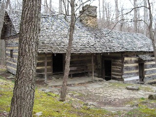
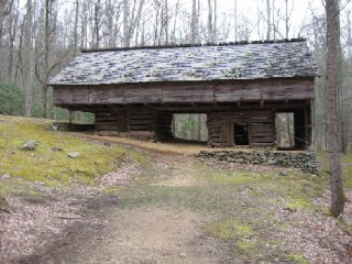
Roughly one mile from the trailhead, after crossing over a footbridge, hikers will reach a fork in the road. The spur trail on the right leads to an historic farm site. A short hike of roughly 250 yards will lead you to the John Messer farm site, which includes a cantilevered barn that was built by John Whaley around 1875. There's also a cabin on this site that was built by the Smoky Mountain Hiking Club in the mid-1930s. Members of the club were permitted to use the cabin as an overnight facility until 1981.
To continue your hike to Brushy Mountain simply retrace your steps, and then take a left at the fork. After walking another 100 feet or so you'll come to another trail junction. Veering to the left here will lead you to Fern Branch Falls. To continue towards your destination you should turn right onto the Brushy Mountain Trail at this junction.
Over the next 4.5 miles the trail climbs more than 2500 feet as it ascends along the northern flanks of Mount LeConte. At roughly 5.5 miles you'll reach Trillium Gap where the Brushy Mountain Trail meets the Trillium Gap Trail. A turn to the left here will lead you to the summit of Mt. LeConte. To continue towards the summit of Brushy Mountain hikers should turn right at this junction.
Although the sign at the junction says that it's only two-tenths of a mile to Brushy Mountain, it's actually about a third-of-a-mile to the summit.
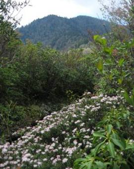
The last push to the summit is a gentle climb through a tunnel of rhododendron, mountain laurel, sand myrtle and other heath family shrubs and bushes. We also saw several painted trillium along this section as well.
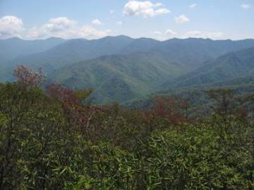
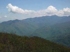
You'll know you've reached the summit when you reach a small semi-circular clearing. Looking towards the southeast this spot offers outstanding views of the entire eastern flank of the Great Smoky Mountains. Hikers will be able to see Charlies Bunion, Mount Sequoyah, Mount Chapman, Mount Guyot and beyond. Mount LeConte will be the dominating feature looking towards the south.
Make sure to continue on the trail for a short distance, roughly 50 feet or so, to reach another vantage point. This spot provides spectacular views of Webb Mountain, the Greenbrier valley and Pigeon Forge towards the north.
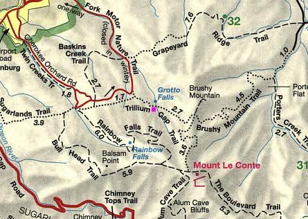
Brushy Mountain Trail Map
Directions to Trailhead:
This hike to Brushy Mountain in the Smokies begins from the Porters Creek Trailhead in the Greenbrier area. To reach the trailhead from the junction of 441 and 321 in Gatlinburg (Light 3), turn to travel eastbound on 321. Drive 6 miles and turn right into Greenbrier (look for the Great Smoky Mountains National Park entrance sign on the right). This road turns into a gravel road after a short distance. From Route 321 drive 3.1 miles to a fork in the road. Continue driving straight ahead here. The parking area will be almost another mile from this junction.