Bullhead Trail Highlights
- Trail Features
Views, Interesting Geology
- Trail Location
Roaring Fork Motor Nature Trail
- Roundtrip Length
5.9 Miles
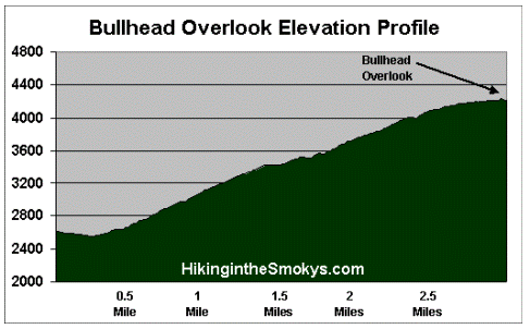
- Elevation Gain (total)
1607 Feet
- Elevation Gain (per mile)
545 Feet
- Trail Difficulty
9.11
Moderately Difficult
This moderately difficult hike is 5.9 miles roundtrip and includes 1607 feet of elevation gain.
Bullhead Trail Description
On October 25, 2018 Great Smoky Mountains National Park announced the reopening of the Bullhead Trail after being closed for almost two years due to the November 2016 wildfire. On November 23, 2016 two juveniles started a wildfire near the summit of Chimney Tops. By November 28th the fire grew to 500 acres. After several months of exceptional drought conditions, and winds gusts reaching more than 80 mph that afternoon, the fire literally exploded. Over the next several hours it burned almost 18,000 acres, including 11,410 acres within Great Smoky Mountains National Park. From Chimney Tops the fire raced north, passing around the edges of downtown Gatlinburg and reaching the outskirts of Pigeon Forge. Before it was brought under control the fire killed 14 people, injured more than 176 people, and damaged or destroyed at least 2460 structures at a cost of more than $500 million.
Just before turning into the parking lot you may have noticed a locked gate blocking an old gravel road. This gate marked the old trailhead for the Bullhead Trail. Hikers will have to follow this gravel road, which is actually the Old Sugarlands Trail, for approximately four-tenths of mile before turning left onto the Bullhead Trail.
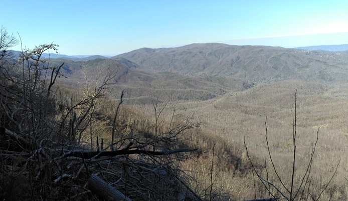
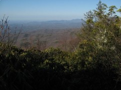
Almost from the beginning you’ll notice evidence of the 2016 wildfire. These were all very small spot fires, likely caused by flying embers from larger burn areas higher up the mountain. As you climb higher the trail will pass through some of these larger burn areas. In some places you'll also notice trees snapped-off or completely blown down, a result of two high-wind events in early 2019. As a result of the wildfire and the blowdowns, hikers now enjoy expansive views of the Gatlinburg area along several sections of the route. However, hikers should heed the warnings from the park that dead trees along the trail can fall at anytime, especially during windy days. During high winds you may want to consider another hike.
At just over a mile from the parking lot the trail begins to ascend more rapidly as you climb the Bullhead, a heath-covered bald extending off Balsam Point. Standing at an elevation of roughly 4300 feet, the bald received its name from to its supposed resemblance to a bulls head from a distance. Over the next mile or so you'll pass several rock cliff faces, and at roughly 1.5 miles from the trailhead, will pass two small caves created by overhanging slabs of rock.
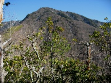
After ascending the west ridge of the Bullhead the trail begins to level out. As you begin traveling along the south side of the mountain the trail also begins to pass through a fairly large burn scar. Almost directly in front you at this point is 5818-foot Balsam Point (see photo on the left).
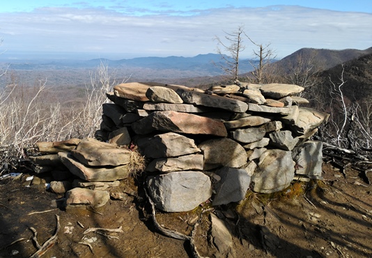
At just under three miles from the trailhead hikers will arrive at a large rock cairn sitting along the side of the trail. This cairn, informally known as "The Pulpit" (see photo below), was built by the Civilian Conservation Corps in the mid-1930's. Originally known as the Bull Head Lookout, the cairn allowed hikers to stand above the rhododendron and view the mountains towards the east and northeast, including Brushy Mountain and the Greenbrier Valley. As a result of the 2016 wildfire, however, the cairn is no longer needed to enjoy the expansive views that were created after the fire burned the trees and rhododendron that had previously blocked vistas in recent decades.
Although this particular hike ends at the Pulpit, hikers will have the option of continuing for another 4.2 miles to reach the summit of Mt. LeConte. From the Pulpit the trail travels up the western slopes of Balsam Point, before exiting onto the ridge to the right of the mountain. Another option, if you still have the energy, is to hike another two miles to this same ridge, which now affords expansive views as a result of the wildfire.
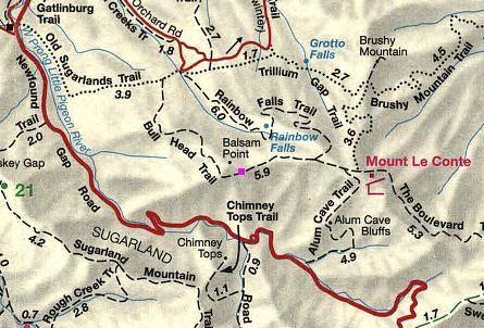
Bullhead Trail Map
Bullhead Trail Elevation Profile
Directions to Trailhead:
The hike along the Bullhead Trail in the Great Smoky Mountains begins from the Rainbow Falls Trailhead, located just outside of Gatlinburg. Starting from Light 8 in Gatlinburg, turn onto Historic Nature Trail / Airport Road. After driving 0.7 miles veer right onto Cherokee Orchard Road, upon which you'll enter into Great Smoky Mountain National Park. After driving another 2.2 miles you'll enter the one-way Cherokee Orchard Loop Road. After driving roughly 0.6 miles on the loop, the Rainbow Falls Trailhead will be located on your right. If this parking lot is full there's an auxiliary parking area about a tenth-of-a-mile further down the road.