Mt. Cammerer Highlights
- Trail Features
Panoramic Views, History
- Trail Location
Cosby
- Roundtrip Length
11.1 Miles
- Elevation Gain (total)
3045 Feet
- Elevation Gain (per mile)
549 Feet
- Trail Difficulty
17.19
Strenuous
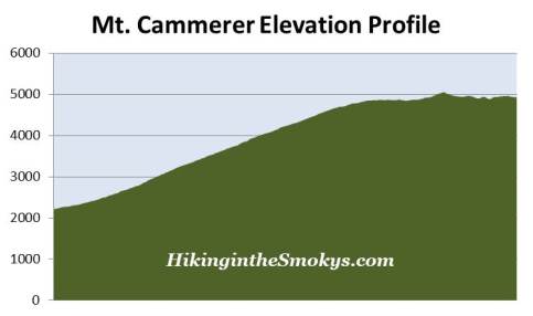
This strenuous hike is 11.1 miles roundtrip and includes 3045 feet of elevation gain.
Mt. Cammerer Description
Although it's a roundtrip hike of more than 11 miles, this hike to Mt. Cammerer is still the shortest and most commonly used route to the summit of the 4928-foot mountain. From the trailhead hikers will climb the Low Gap Trail for three long miles before reaching the Appalachian Trail. This is a steep and relentless climb that traverses over several switchbacks, while taking hikers through a beautiful, mature hardwood forest as they proceed up the Cosby Creek valley.
The first section of trail travels between Cosby Creek and the Cosby Campground. Portions of this section share the same route with the Cosby Nature Trail, a short loop hike that begins from the campground. At four-tenths of a mile from the trailhead you'll reach the Lower Mt. Cammerer Trail junction. To continue on the Low Gap Trail you should turn right here.
At just over eight-tenths of a mile hikers will reach an alternative path for reaching the Low Gap Trail. Although this spur trail would shave some distance off your hike, you have to stay at the campground in order to use this route.
At roughly 2.9 miles hikers will finally reach the Appalachian Trail. By this point you will have already climbed more than two thousand feet, thus completing the hardest part of the hike. During our most recent visit, in early May, we were greeted by a carpet of fringed phacelia at this junction. There were literally thousands of these tiny, but beautiful wildflowers covering the forest floor here.
To continue on towards the Mount Cammerer Trail hikers should turn left at this junction.
Along the early portions of the Appalachian Trail you'll continue climbing, however, the terrain isn't quite as steep as the Low Gap Trail. At roughly 3.7 miles the trail begins to level off, and travel becomes much easier. Hikers will now traverse along a ridge that offers decent views of the Cosby and Toms Creek valleys through the trees.
At just under 5 miles hikers will reach the rugged spur trail that leads to the summit of Mt. Cammerer. The spur is roughly six-tenths of a mile long, is fairly level, but does involve some rock scrambling as you approach the fire lookout. Although the last tenth-of-a-mile traverses over some fairly rugged terrain, it's nothing that would be considered exceedingly difficult.
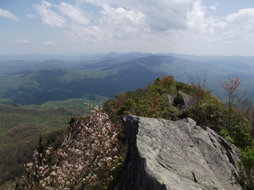
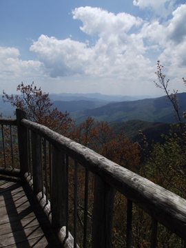
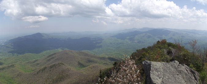
Standing at an elevation of 4928 feet, the summit of Mt. Cammerer sits on the edge of a rocky outcropping overlooking the Pigeon River Gorge. On a clear day the views are simply stunning; some even say one of the best in the park, which includes me. In fact, I have ranked this as second on my list of the Best Hikes in the Smokies.
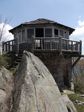
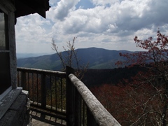
For an even better vantage point, step up to the deck of the stone fire lookout. This "western" style tower, which was fully restored in 1995, provides hikers with outstanding 360-degree views. Look in any direction and see row upon row of mountains. The mountain directly across the gorge, with the white aviation tower at the top, is 4263-foot Snowbird Mountain. Below that you may be able to see the water tower for the hydro-electric plant in the Big Creek area. Towards the south is Mt. Sterling, which also has an old fire tower atop its summit. And of course, towards the southwest, is the seemingly endless expanse of mountains known as the Great Smoky Mountains.
Using hand-cut stone, the octagonal fire lookout atop the summit of Mt. Cammerer was built by local laborers and the Civilian Conservation Corp in the late 1930s. The men who built the lookout drilled and blocked the stone from a quarry only one hundred yards downhill from the tower. Some of these stones weighed as much as 600 pounds!
The architectural style used for the lookout was called "western" because it didn't require a raised structure to see above the trees.
Between February 15th and May 15th, and then again from October 15th through December 15th, the structure was manned by lookouts who lived on the premises on two-week tours. This lookout was operated until the 1960s when modern fire detection methods were able to replace it.
The mountain itself is named after Arno Cammerer, the well-liked Director of the National Park Service in the 1930s. Cammerer was an instrumental figure in helping to establish a national park in the Great Smoky Mountains. With the help of Colonel David C. Chapman of Knoxville, Cammerer convinced John D. Rockefeller Jr. to make a gift of $5 Million, which was used to purchase the lands that would become the national park.
During Cammerer's tenure as Director the number of areas under the National Park Service tripled, while visitation jumped from roughly 2 million to 16 million people a year. After his death in 1941, the peak formerly known as "White Rocks" received his name. My new book on the history of hiking includes much more information about trail development in the Smokies, as well as other anecdotal stories from the early years of the park.
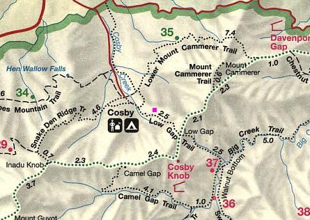
Mt. Cammerer Map
Mt. Cammerer Elevation Profile
Directions to Trailhead:
This hike to Mt. Cammerer in the Great Smoky Mountains begins from the Low Gap Trailhead next to the Cosby Campground. To reach the trailhead from the junction of 441 and 321 in Gatlinburg (Light 3), turn to travel eastbound on Highway 321/73 for 18.2 miles until the road dead-ends into Highway 32. Turn right towards Cosby and drive 1.2 miles to the park entrance. Turn right into the park and drive another 2.1 miles to the Cosby Campground entrance station. At the entrance station you'll be directed to turn left into a large parking area for the Low Gap Trailhead.