Charlies Bunion Highlights
- Trail Features
Panoramic Views
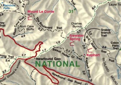
- Trail Location
Newfound Gap
- Roundtrip Length
8.1 Miles
- Elevation Gain (total)
1640 Feet
- Elevation Gain (per mile)
405 Feet
- Trail Difficulty
11.38
Strenuous
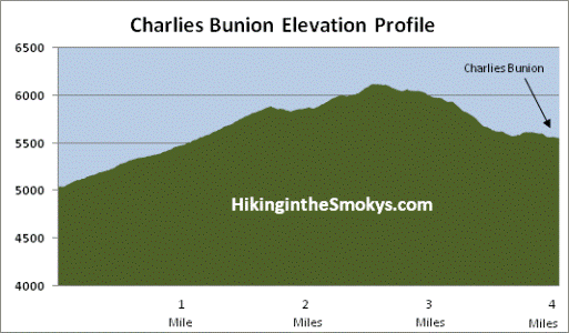
This strenuous hike is 8.1 miles roundtrip and includes 1640 feet of elevation gain.


Charlies Bunion Description
The hike to Charlies Bunion begins from the large parking area at Newfound Gap. Hikers will travel eastbound along the Appalachian Trail to reach this popular rock outcropping. The steady climb over the course of the first two miles of this hike will quickly leave the crowds behind at Newfound Gap. For your effort during this portion of the hike you'll be rewarded early and often. At roughly two-thirds of a mile you'll enjoy grand views of the North Carolina Smokies towards the south. Hikers will also enjoy a wide variety of wildflowers that bloom at these elevations during the spring and early summer, including varieties such as violets, spring beauty and trout lilies.
Just before reaching the Sweat Heifer Creek Trail junction, roughly 1.7 miles from the trailhead, be sure to take in the outstanding views of Mount LeConte and Myrtle Point towards the northwest.
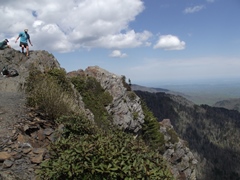
Throughout several portions of the hike you'll be traveling at elevations hovering around 6000 feet. Being at the highest point along this narrow ridge, with stunning views on either side of the trail, you'll feel like you're walking on the spine of the Appalachian Mountains.
At just over 2.7 miles the Boulevard Trail to Mount LeConte forks off to the left. Hikers should proceed straight ahead to continue towards Charlies Bunion.
A quarter-of-a-mile further down the trail you'll pass the Icewater Spring shelter, which is named after the nearby spring that flows from a pipe onto the Appalachian Trail. If thirsty, you'll need to treat this water first before drinking it.
At roughly 4 miles from the trailhead a short spur trail will branch off to the left and lead you to your destination.
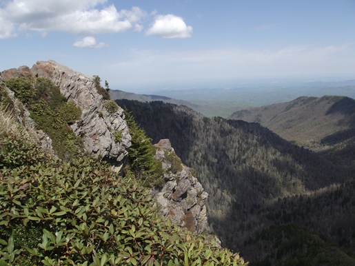
Charlies Bunion is a rock outcropping that was originally known as Fodderstack. The current name was derived when Charlie Conner went hiking one day with Horace Kephart, one of the early proponents for a national park in the Smokies, and the author of Our Southern Highlanders. When they paused for a rest on the rocks, Conner took his boots and socks off and exposed a bunion that resembled the surrounding rocks. Looking at Conner's feet, Kephart remarked, "Charlie, I'm going to get this place put on a government map for you." And so he did. My new book on the history of hiking has much more information about trail development in the Smoky Mountains, as well as other anecdotal stories from the early years of the park.
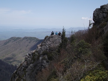
Charlies Bunion offers spectacular views of the mountains to the north, Mt. Kephart and the Jump Off to the west, and Mount Guyot towards the east. Due to the extremely steep drop-offs you'll definitely want to watch you're footing in this area.
If you still have the energy on your return trip, take the relatively short side trail to visit the Jump Off, located near the Boulevard Trail junction. The stunning views from this rock outcropping are definitely well worth the additional one-mile roundtrip.
Charlies Bunion Map
Charlies Bunion Elevation Profile
Directions to Trailhead:
The hike to Charlies Bunion in the Great Smoky Mountains begins from Newfound Gap. To reach the trailhead from the Sugarlands Visitor Center near Gatlinburg, drive 13 miles south along Newfound Gap Road.
From Cherokee, drive 20.2 miles north to reach the parking area at Newfound Gap.