Chimney Tops Trail Highlights
- Trail Features
Panoramic views, Cascading stream
- Trail Location
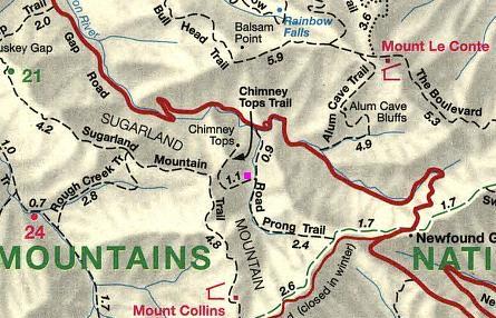
Newfound Gap Road
- Roundtrip Length
3.3 Miles
- Elevation Gain (total)
1487 Feet
- Elevation Gain (per mile)
901 Feet
- Trail Difficulty
6.27
Moderately Difficult
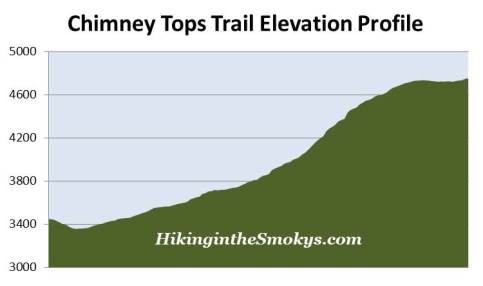
This moderately difficult hike is 3.3 miles roundtrip and includes 1487 feet of elevation gain.
Chimney Tops Trail Description
On October 6, 2017, Great Smoky Mountains National Park reopened the Chimney Tops Trail to a newly constructed observation point. The popular hiking trail was closed for almost a full year due to the November 2016 wildfire. As a result of that fire, the area around the pinnacles was completely destroyed, and is now considered unsafe. While the trail was closed park crews constructed a new observation deck, located roughly a quarter-mile below the actual summit, which provides views of Mount LeConte and the Chimney Tops pinnacles.
On November 23, 2016 two juveniles started a wildfire near the Chimney Tops summit. By November 28th the fire grew to 500 acres. After several months of exceptional drought conditions, and winds gusts reaching more than 80 mph that afternoon, the fire literally exploded. Over the next several hours it burned almost 18,000 acres, including 11,410 acres within Great Smoky Mountains National Park. From Chimney Tops the fire raced north, passing around the edges of downtown Gatlinburg and reaching the outskirts of Pigeon Forge. Before it was brought under control the fire killed 14 people, injured more than 176 people, and damaged or destroyed at least 2460 structures at a cost of more than $500 million.
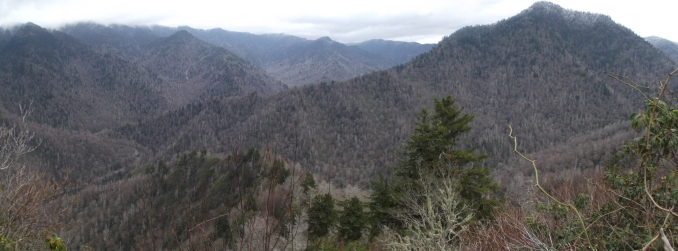
Before the fire the Chimney Tops Trail was one of the most popular hikes in the Smokies, and we assume it will continue to be a favorite destination for park visitors. The trail owes much of its popularity to its relatively short length, and its outstanding panoramic views from the summit area. Its length, less than 2 miles, however, makes for a very steep hike - so much so that many hikers don't even reach the top. The first half of the trail is relatively tame. However, to reach the summit area hikers have to climb more than 960 feet over the course of the last mile! This is similar to the rate of elevation gain you'll find on some of the 14,000-foot peaks in Colorado.
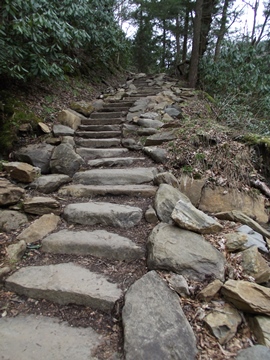
In 2012 the Trails Forever program launched a multi-year project to rehabilitate this extremely popular trail. The combination of heavy use, abundant rainfall and steep terrain had turned the Chimney Tops Trail into what was described as "a badly eroded obstacle course of slick broken rock, exposed tree roots and mud". Over time these hazards forced hikers to trek across uneven surfaces, or encouraged them to walk along the edges of the trail, all of which resulted in extensive erosion and resource damage.
Restoration efforts by Trails Forever crews included construction of rock steps, redefining sections of trail that were unsafe or difficult to navigate, improved drainage, as well as the construction of raised turnpike structures to prevent further erosion. In all, Trails Forever crews installed a total of 367 stone steps - each weighing roughly 300 pounds!
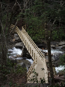
At one point progress on the project was delayed several months due to flooding rains. After several weeks of above average rainfall, the Great Smoky Mountains received more than 4 inches of rain in one 24-hour period on January 30, 2013. The resulting floods washed out the 70-foot footbridge that spanned the Walker Camp Prong near the trailhead, which forced the closure of the entire trail for more than five months.
The first section of trail more or less follows the cascading waters of Road Prong Creek, and crosses several footbridges along the 0.9-mile route to Beech Flats. If you're hiking during the spring or early summer, look for rhododendron, mountain laurel and many other wildflowers blooming along the trailside during this time period. The trail junction at Beech Flats marks the approximate half-way point for this hike. From here the Road Prong Trail branches off to the left towards the Appalachian Trail at Indian Gap, roughly 2.4 miles away. The Road Prong Trail, which continues to follow the stream of the same name, is one of the oldest trails in the Smokies. In the 18th and 19th centuries this ancient path was commonly known as the Indian Gap Trail.
To reach the Chimney Tops you'll have to stay on the main path, which veers towards the right.
Now the fun begins - that is, if you enjoy hiking up steep terrain. From the junction the trail takes a westerly course and climbs roughly 730 feet over the next two-thirds of a mile, before swinging northward to climb the ridge leading towards the summit. As this ridge narrows hikers will begin to enjoy some decent views of the mountains towards the east.
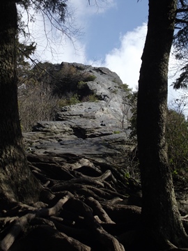
As mentioned above, this hike officially ends roughly one-quarter of a mile below the pinnacles. The new observation point, however, provides outstanding views of Mount LeConte and the pinnacles. For the safety of all hikers, the park has blocked all access beyond this point. It's possible this final section could reopen someday down the road. In an October 3, 2017 press release, park officials stated that, "If in the future the ground is determined to be safe and stabilized enough for sustainable trail construction, the park will consider trail rehabilitation of this area."
Chimney Tops is one of the few mountains in the Smokies that has a bare rock summit. The Cherokee name for Chimney Tops is Duniskwalgunyi, or "forked antler", which refers to its resemblance to the antlers of a young deer.
Although it might be warmer during the summer months, and will likely be much more crowded, I would recommend waiting until the afternoon to start your hike. Waiting until later in the day allows you to view the mountains across the valley without having to peer through the morning sun's haze.
Novice hikers should also note that the Chimney Tops Trail is a very strenuous hike. Although it's rated as moderate, due to its relatively low mileage, it's actually much more difficult as a result of its extreme elevation gain.
Chimney Tops Trail Map
Chimney Tops Trail Elevation Profile
Directions to Trailhead:
The hike to Chimney Tops in the Great Smoky Mountains begins from the Chimney Tops Trailhead, located roughly 6.9 miles south of the Sugarlands Visitor Center (near Gatlinburg), between the lower tunnel and "the loop" on Newfound Gap Road.