Deep Creek Loop Highlights
- Trail Features
Waterfalls, Wildflowers
- Trail Location
Deep Creek
- Roundtrip Length
4.6 Miles
- Elevation Gain (total)
579 Feet
- Elevation Gain (per mile)
252 Feet
- Trail Difficulty
5.76
Moderately Difficult
This moderately difficult hike is 4.6 miles roundtrip and includes 579 feet of elevation gain.
Deep Creek Loop Description
The Deep Creek Loop hike begins from the Deep Creek Trailhead. The Deep Creek Trail was one of the first trails constructed by the Civilian Conservation Corps in the newly legislated park in the early 1930s. The current Deep Creek Campground also served as the site for the Deep Creek CCC Camp from 1933 to 1936.
In 1910 Horace Kephart, author of Our Southern Highlanders, lived for a short time with the Bob Barnett family in one of the last houses located along the upper portions of Deep Creek. Until his death, as a result of an automobile accident in 1931, Kephart also used the old Bryson Place as his summertime camping spot. A permanent historical marker near Backcountry Campsite 57, located just north of the junction between the Deep Creek Trail and Martins Gap Trail, now commemorates the site.
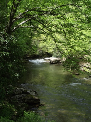
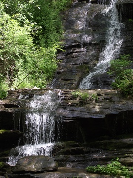
The trail begins as a wide path as it traces Deep Creek upstream. Rewards are almost immediate on this hike. Only three-tenths of a mile from the trailhead, the 80-foot Toms Branch Falls (photo on the right) spills down into the creek from the opposite bank. The Great Smoky Mountains National Park has provided several benches for admiring this beautiful waterfall.
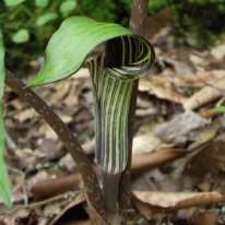
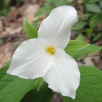
Wildflowers are also quite abundant along this trail. As you proceed towards Indian Creek Falls you'll find a variety of trilliums, blooming at different times throughout the spring, as well as foamflower, galax, crested dwarf iris, beard tongue, Solomon's seal, cinquefoil, bloodroot, bluets and blue-eyed grass. Jack-in-the-pulpit is also abundant, but is sometimes hard to locate among the wild geranium, clinton's lily and the large houstonia.
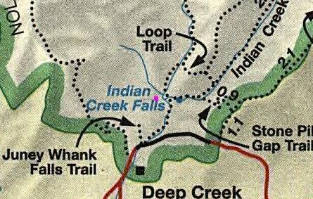
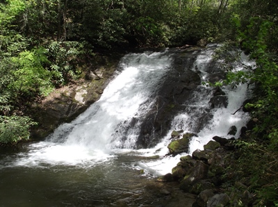
At 0.8 miles hikers will arrive at the Indian Creek Trail junction. You should turn right onto the Indian Creek Trail to begin the loop portion of the hike. After walking only one-tenth of a mile there will be a short spur trail that leads down to Indian Creek Falls on your left. This is an awesome 45-foot falls. As you climb back to the main trail, and begin passing above the falls, you'll likely notice that Indian Creek Falls is actually more of a water slide than a true waterfall.
As you continue along the loop portion of the hike you'll soon cross over a footbridge. You'll also likely notice that the Indian Creek valley, now on your right, is choked with rhododendron throughout this section of the route.
At roughly 1.4 miles the Stone Pile Gap Trail branches off to the right, and leads to the Thomas Divide Trail in less than a mile. Hikers should proceed straight ahead at this junction.
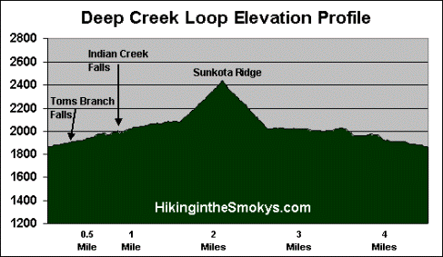
At 1.7 miles you'll arrive at the Deep Creek Loop Trail junction. Hikers should turn left here to continue on the loop hike. For the next half-mile you'll climb roughly 350 feet before reaching the Sunkota Ridge Trail junction. After turning onto the Loop Trail you'll quickly leave behind the noise from Indian Creek, and with the possible exception of the sound of your own heavy breathing, enter a noticeably much quieter valley.
As you proceed higher you'll begin to notice mountain laurel, rhododendron and flame azalea growing along this portion of the route.
After reaching the Sunkota Ridge junction hikers should proceed straight ahead to continue on the loop hike. From here it's all downhill until reaching Deep Creek once again. Upon reaching the Deep Creek Trail junction, roughly 2.9 miles from the trailhead, hikers should turn left, cross the footbridge, and then follow the trail back to the parking lot. From this point forward the trail travels over relatively flat terrain.
On your way back to the parking lot, at roughly 3.7 miles, hikers will reach a spur trail that leads to Juney Whank Falls, a pleasant 80-foot cascade. The spur travels roughly 1.2 miles to the falls, and then another quarter-mile back to the parking area, in case you prefer to take this alternate route back to the trailhead.
If you bypass the Juney Whank Falls spur you'll exit the loop portion of the hike in just one-tenth of a mile, at the Indian Creek Trail junction. Hikers should proceed straight ahead at this junction for another eight-tenths of a mile to return back to the parking area.
Deep Creek Loop Map
Deep Creek Loop Elevation Profile
Directions to Trailhead:
The trailhead for the Deep Creek Loop in the Great Smoky Mountains is located just north of Bryson City, North Carolina. To reach the trailhead from the intersection of Rt. 441 and Rt. 19 in Cherokee, drive 10 miles south on Route 19 to Everett Street in Bryson City. Turn right onto Everett and drive for 0.2 miles, and then turn right onto Depot Street. After a short distance turn left onto Ramseur Street, and then make an immediate right onto Deep Creek Road. Drive another 2.3 miles to the park entrance, and then from there another half-mile to the parking lot for the Deep Creek Trailhead.