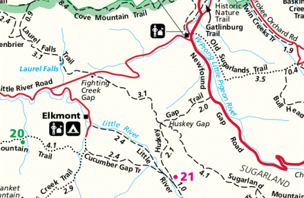
Huskey Gap (via Little River Trail) Highlights
- Trail Features
Stream, Wildflowers, History
- Trail Location
Elkmont
- Roundtrip Length
10.0 Miles
- Elevation Gain (total)
1080 Feet
- Elevation Gain (per mile)
216 Feet
- Trail Difficulty
12.16
Strenuous
This strenuous hike is 10.0 miles roundtrip and includes 1080 feet of elevation gain.
Huskey Gap (via Little River Trail) Description
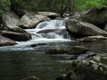
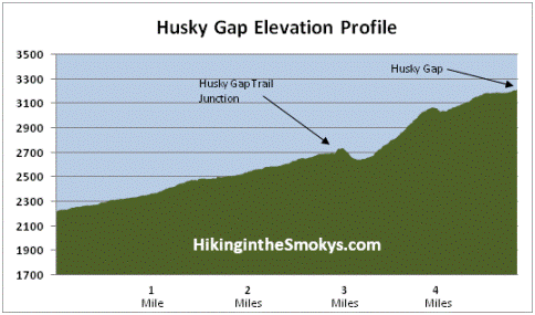
To reach Huskey Gap on this hike you'll first have to walk almost 3 miles along the Little River Trail. This trail ascends a gentle grade along an old gravel railroad bed that parallels the Little River, a beautiful cascading stream with large boulders and several small waterfalls.
The headwaters for the Little River are located along the northern slopes of Clingmans Dome, just below the Appalachian Trail. From the highest mountain in the Smokies the river flows 60 miles to reach the Tennessee River near Alcoa. The river is now on the list of Outstanding National Resource Waters, which means it has the highest degree of protection. The exceptionally clean water of the Little River supports a wide variety of aquatic life, including the eastern hellbender, a giant salamander that can measure more than two feet in length.
If you're lucky you might spot an otter in or around the stream. Between 1988 and 1990 park biologists released 14 river otters into the Little River as part of a successful effort to reintroduce the species throughout the Great Smoky Mountains.
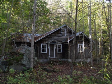
Near the trailhead hikers will pass by several old cottages. Most of these former resort cottages were built in the 1920s, and were used as summer homes by the affluent from Knoxville. As of this writing the homes are in disrepair and are off limits to the public. However, in the fall of 2008, National Park Service crews completed emergency stabilization to 18 of the historic cabins, as well as the Appalachian Clubhouse. The park plans to fully restore all 19 structures so that they can be opened and viewed by the public. As part of the first phase of the Elkmont restoration project, the National Park Service reopened the old Appalachian Clubhouse for public rental in June of 2011.
At this time it's not clear as to when this project will be fully completed. In 2017 the park began the process of removing the other 55 buildings in the area and returning those sites to their natural habitats.
The Elkmont area of the park was heavily logged from the late 1800s through 1938. In the early years logs were hauled out by ox teams, and then floated down river. Just after the turn of the century the Little River Lumber Company purchased nearly 100,000 acres of timberland along the Little River and its tributaries. They built rail lines to Elkmont, and eventually, a spur that extended all the way to Clingmans Dome. This spur would eventually become the Little River Trail. These rail lines allowed the company to extract timber at a much faster rate. After the Smokies became a national park the lumber company ceased operations in 1938, and had rolled up its tracks by early 1940.
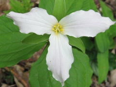
Along the lower portions of the trail hikers will stroll past several patches of rhododendron. As we proceeded up river we also noticed yellow trillium, dwarf cinquefoil and stonecrop, among several other varieties.
At roughly 2.2 miles hikers will reach Huskey Branch Falls, a small 20-foot cascade that tumbles into the Little River. The waterfall flows down the slope along the hill next to the trail before running underneath a small footbridge.
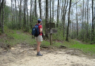
At just under 2.5 miles hikers will arrive at the Cucumber Gap Trail junction. To reach Huskey Gap continue straight ahead for another four-tenths of a mile, just past the old railroad bridge that crosses over the Little River, and then turn left onto the Huskey Gap Trail.
Once beyond the river you'll likely notice how much more quiet this new trail is compared to the Little River Trail.
Almost immediately after turning onto the Huskey Gap Trail you'll begin a short ascent to the top of a low ridge. After cresting this relatively easy climb you'll begin descending into a meadow carpeted with lush-green ferns. Along this strech of trail we also began to notice a fair amount of yellow trillium.
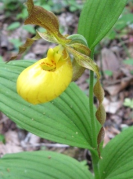
This, however, was nothing compared to what we saw further up the trail. Roughly half-way between the Little River Trail and Huskey Gap we ran into an absolute riot of flowers: yellow, white and painted trillium, blue phlox, hepaticas, violets and even a few yellow lady's slippers. There were a couple of hillsides throughout this stretch of trail that were literally covered in wildflowers. Obviously this is an outstanding hike option during the April and May time period if your goal is to see wildflowers.
At roughly 5 miles you'll finally reach Huskey Gap where the Huskey Gap Trail intersects with the Sugarland Mountain Trail. You won't have much of a view here, but you will have a few peeks into the mountains towards the west over the course of the last half-mile up to the gap. The Huskey Gap Trail continues for another 2.1 miles to Newfound Gap Road if you wish to add more mileage to your hike.
Huskey Gap (via Little River Trail) Map
Huskey Gap (via Little River Trail) Elevation Profile
Directions to Trailhead:
From the Sugarlands Visitor Center near Gatlinburg, drive 4.9 miles west along Little River Road to reach the turnoff for the Elkmont Campground, which will be on your left. After turning into Elkmont, drive 1.4 miles to the campground entrance. Instead of proceeding into the campground, turn left and drive another 0.6 miles to reach the parking area for the Little River Trail. The Huskey Gap Trail is accessed via the Little River Trail.
From the Townsend "Y" intersection near Cades Cove, the turnoff for the Elkmont Campground will be 12.6 miles away.