The Jumpoff Highlights
- Trail Features
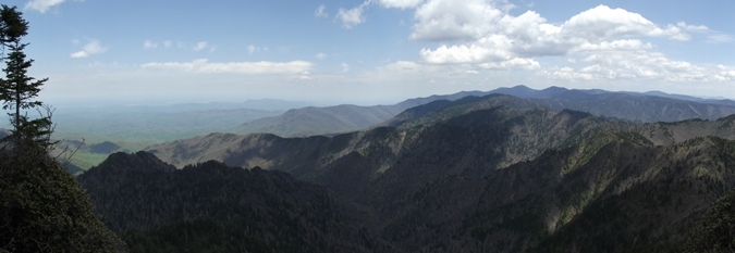
Panoramic Views
- Trail Location
Newfound Gap
- Roundtrip Length
6.5 Miles
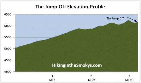
- Elevation Gain (total)
1275 Feet
- Elevation Gain (per mile)
392 Feet
- Trail Difficulty
9.05
Moderately Difficult
This moderately difficult hike is 6.5 miles roundtrip and includes 1275 feet of elevation gain.


The Jumpoff Description
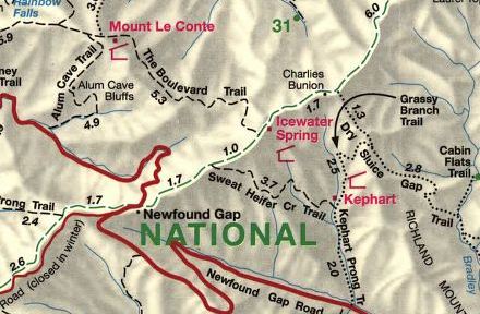
The hike to the Jump Off begins from the large parking area at Newfound Gap. Hikers will travel eastbound along the Appalachian Trail to reach this rock outcropping. The steady climb over the course of the first two miles of this hike will quickly leave the crowds behind at Newfound Gap. For your effort during this portion of the hike you'll be rewarded early and often. At roughly two-thirds of a mile you'll enjoy grand views of the North Carolina Smokies towards the south. Hikers will also enjoy a wide variety of wildflowers that bloom at these elevations during the spring and early summer, including spring beauty, violets and trout lilies.
Just before reaching the Sweat Heifer Creek Trail junction, roughly 1.7 miles from the trailhead, be sure to take in the outstanding views of Mount LeConte and Myrtle Point towards the northwest.
Throughout several portions of the hike you'll be traveling at elevations hovering around 6000 feet. Being at the highest point along this narrow ridge, with stunning views on either side of the trail, you'll feel like you're walking on the spine of the Appalachian Mountains.
At just over 2.7 miles from the trailhead you'll arrive at the Boulevard Trail junction. Hikers should turn left here.
Less than a tenth-of-a-mile after turning onto the Boulevard Trail you'll reach the junction for the Jump-Off. Although this side trail is not an official national park trail, it is marked with a sign. And though it has a few rugged sections, the route is easy to follow.
As you approach the Jump Off hikers will enjoy great views of Mount LeConte towards the northwest. At roughly 3.2 miles from the parking lot at Newfound Gap, hikers will arrive at the Jump Off. From this vantage point you'll have spectacular views of Charlies Bunion, Mount Guyot, and the Appalachian Trail ridge towards the east. This is also an excellent place for a picnic, as it comes with a degree of solitude when compared to the far more popular Charlies Bunion.
If you still have the energy you'll have the option of hiking out to Charlies Bunion on your return trip. Instead of returning back to the parking lot after reaching the Boulevard Trail-Appalachian Trail junction, turn left and head east on the Appalachian Trail. The stunning views from this rock outcropping are well worth the additional two-and-a-half mile roundtrip hike.
The Jumpoff Map
The Jumpoff Elevation Profile
Directions to Trailhead:
The hike to the Jump Off in the Great Smoky Mountains begins from Newfound Gap. To reach the trailhead from the Sugarlands Visitor Center near Gatlinburg, drive 13 miles south along Newfound Gap Road.
From Cherokee, on the North Carolina side of the Great Smoky Mountains, drive 20.2 miles north to reach the Newfound Gap.