Kephart Prong Trail Highlights
- Trail Features
History, Stream
- Trail Location
Between Cherokee and Newfound Gap
- Roundtrip Length
4.2 Miles
- Elevation Gain (total)
955 Feet
- Elevation Gain (per mile)
455 Feet
- Trail Difficulty
6.65
Moderately Difficult
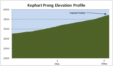
This moderately difficult hike is 4.2 miles roundtrip and includes 955 feet of elevation gain.
Kephart Prong Trail Description
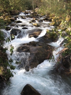
The hike to the Kephart Shelter at the end of the Kephart Prong Trail begins by crossing a footbridge over the Oconaluftee River.
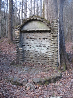
Just two-tenths of a mile from the trailhead you'll reach the Great Depression era remains of an old Civilian Conservation Corps (CCC) camp. One of the first remnants you'll notice will be the chimney from the camp barracks. Close by is the rock framing for the camp signboard. Look a little closer and you may notice a water fountain in this vicinity as well.
The Civilian Conservation Corps camp was located here between 1933 and 1942. During its peak there was a barracks building, a structure that housed officers, a mess hall, a recreation hall, and several other specialized structures. The 200-plus members of Company 411 that occupied this camp built six miles of road (North Carolina Highway 107), created the water system that still serves Newfound Gap, built almost two dozen fish rearing ponds, constructed parking areas, and played an important role in the construction of Newfound Gap Road. The company also took part in trail work, including the construction of many of the footbridges along the Kephart Prong Trail, which are still buttressed by the original CCC stonework.
During this same time period the Works Project Administration built a fish hatchery near this location, which was used to replenish trout and bass in the local mountain streams. If you do a little exploring off the trail in this area you'll come across several large pipes scattered in the weeds, which I assume were used to divert water from the stream to the hatchery.
During World War II the camp was used to house conscientious objectors to the war. The "conchies," as they were known locally, were excused from military duties but were still expected to serve their country. They took over some of the park maintenance duties previously handled by the CCC, served as school instructors for the children of park rangers, planted trees, and were responsible for a variety of other chores while living in the camp.
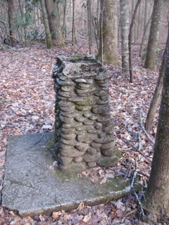
Just beyond the camp area you'll see a fairly large cement block just above the left side of the trail. This was possibly used as a cistern for the camp.
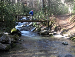
From here the trail continues to make a steady ascent up the southern slopes of Mt. Kephart. Along the way you'll cross four more footbridges - a few of which I wouldn't want to cross when it's icy or wet, due to the narrow logs being covered in moss, and smoothed from old age.
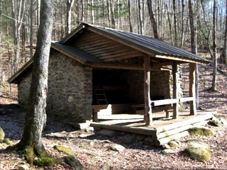
At 2.1 miles you'll reach the Kephart Shelter at the junction with the Sweat Heifer Creek Trail and the Grassy Branch Trail. This marks the end of the trail for most hikers, however, if you still have a lot of energy you could continue onto Charlies Bunion by taking the Grassy Branch Trail up to the Dry Sluice Gap Trail. From there you'll head north on Dry Sluice Gap, and then proceed westbound on the Appalachian Trail for only a short distance to reach Charlies Bunion. Taking this route would be a 12.5-mile roundtrip hike from the Kephart Prong trailhead.
The mountain, waterway, trail and shelter are all named for Horace Kephart, an early proponent of national park status for the Smokies, and whose book, Our Southern Highlanders, is a classic study of mountain culture. Two months prior to his death, as a result of an automobile accident in 1931, Mount Kephart, the 9th highest mountain in the park, was renamed in his honor. Prior to that, the mountain was known as Mt. Collins. The mountain just west of Newfound Gap now bears the name of Mt. Collins.
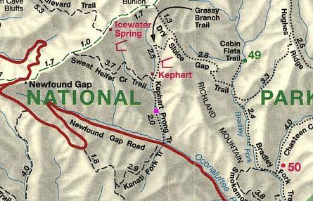
Kephart Prong Trail Map
Kephart Prong Trail Profile
Directions to Trailhead:
The hike along the Kephart Prong Trail in the Great Smoky Mountains begins from the Kephart Prong Trailhead on Newfound Gap Road. To reach the trailhead from the Oconaluftee Visitor Center near Cherokee, drive 7.3 miles north on Newfound Gap Road to the parking area for the Kephart Prong Trail, located on your right, just off the side of the road.
From the Sugarlands Visitor Center near Gatlinburg you'll drive 21.8 miles south on Newfound Gap Road to reach the trailhead.