Laurel Falls Highlights
- Trail Features
Waterfalls
- Trail Location
Little River Road
- Roundtrip Length
2.3 Miles
- Elevation Gain (total)
314 Feet
- Elevation Gain (per mile)
273 Feet
- Trail Difficulty
2.93
Easy
This easy hike is 2.3 miles roundtrip and includes 314 feet of elevation gain.
Laurel Falls Description
Laurel Falls is an extremely popular destination within Great Smoky Mountains National Park. Thus, parking can be a problem during peak season. If you wish to avoid crowds your best bet is to begin your hike early in the morning, during the early evening hours, on a weekday, or during the off-season.
The Laurel Falls Trail was built in 1932 to provide fire crews with access to the Cove Mountain area in the event of a forest fire. By the early 1960s, however, Laurel Falls had become a popular hiking destination for visitors, and erosion was beginning to take a toll on the trail. As part of the 1963 Accelerated Works Projects grant to the Department of Interior, the Laurel Falls Trail was paved in order to halt problems associated with erosion. My new book on the history of hiking has much more information about trail development in the Smokies, as well as other anecdotal stories from the early years of the park.
As in decades past, you'll still find a lot of families with young children on this extremely popular trail. If you do plan to hike with young children, I highly suggest keeping a close eye on them at all times as the trail passes next to some very steep drop-offs, especially as you get closer to the falls.
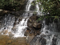
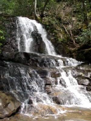
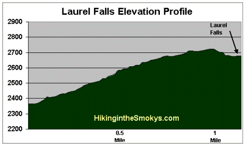
Roundtrip, the hike to Laurel Falls and back is 2.3 miles in total length. Hikers will climb roughly 314 feet in elevation before arriving at the 80-foot waterfall. The hike is well worth it though - Laurel Falls is very photogenic, and is widely considered to be one of the best waterfall hikes in the Smokies.
The waterfall consists of an upper and a lower section, divided by a walkway which crosses the stream (Laurel Branch) at the base of the upper falls. The falls receives its name from the mountain laurel that blooms along the trail and near the falls in May.
If you wish to go home with some great photographs of the waterfall you may want to consider planning your hike for early in the morning, or late in the day. The shade provided by the surrounding mountains will likely produce a much better photograph.
Visitors should also note that you'll be traveling in bear country on this hike. Although it may not seem like it, due to the scores of people on the trail at any given time, but black bears are still present in this area. On our most recent hike we saw a mother and three cubs roughly 50 yards off the trail.
If you still have plenty of energy left in your legs after soaking in the sights at the waterfall, hikers will have the option of continuing along the Laurel Falls Trail for another 2.7 miles to visit the old fire tower atop Cove Mountain.
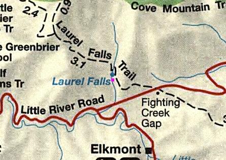
Laurel Falls Map
Laurel Falls Elevation Profile
Directions to Trailhead:
The hike to Laurel Falls in the Great Smoky Mountains begins from Fighting Creek Gap on Little River Road, located 3.8 miles west of the Sugarlands Visitor Center near Gatlinburg. The main parking lot for Laurel Falls will be on your right, with additional parking across the street.
From the Townsend "Y" intersection near Cades Cove, the Laurel Falls is 13.7 miles away.