
Mt. LeConte (via Alum Cave Trail) Highlights
- Trail Features
Panoramic Views, history, geological
- Trail Location
Newfound Gap Road
- Roundtrip Length
11.0 Miles
- Elevation Gain (total)
2763Feet
- Elevation Gain (per mile)
502 Feet
- Trail Difficulty
16.53
Strenuous
This strenuous hike is 11.0 miles roundtrip and includes 2763 feet of elevation gain.

Mt. LeConte (via Alum Cave Trail) Description
If ever there was a classic hike in Great Smoky Mountains National Park, the Alum Cave Trail to Mt. LeConte would certainly qualify. Sure, there are hikes in the Smokies that are far longer, gain more elevation, or have steeper climbs, but the Alum Cave Trail is unmatched in its combination of interesting geological features, history, high adventure and stunning panoramic views.
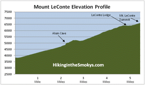
To reach the 6593-foot summit of Mount LeConte hikers will have to climb 2763 feet, and hike 5.5 miles from the Alum Cave Trailhead.
The first section of the Alum Cave Trail, up to Arch Rock, travels over a fairly gentle grade. Hikers will follow Alum Cave Creek over the course of the first mile. Just before reaching Arch Rock, however, the trail begins following the Styx Branch. This section of trail is choked with rosebay rhododendron, which offers beautiful blooms during the early summer.
The night before one of our hikes in the spring of 2008, a strong storm blew through the Smokies and dropped marble-sized hail, which still littered the trail the next morning. Guests returning from their stay at the LeConte Lodge the night before reported that the top of the mountain received nearly six inches of hail. They also related how they watched an incredible display of lightning below them, just before the storm moved up and over the mountain.
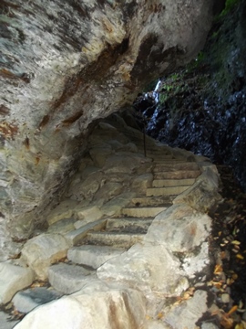
At just over 1.3 miles from the trailhead hikers will reach Arch Rock, the first prominent landmark along the trail. The arch was formed by freezing and thawing, which eroded away the softer rock from underneath the harder rock. The trail actually goes under the arch and requires a climb of several steps etched into the stone before exiting at the top.
Beyond Arch Rock the trail begins ascending towards Alum Cave. Anakeesta Ridge will dominate the views on your left throughout this stretch. At roughly 2 miles from the trailhead hikers will reach the appropriately named Inspiration Point, a heath bald that offers commanding views of Little Duck Hawk Ridge to the west and Myrtle Point towards the northeast. The Eye of the Needle, a hole in the rock near the top of Little Duck Hawk Ridge, can also be seen from this vantage point.
A much better view of the Eye can be found a tenth-of-a-mile further up the trail. While descending the trail on our return trip we watched as two peregrine falcons playfully swooshed through the air near the Eye. In case you're unaware, peregrine falcons are also known as duck hawks.
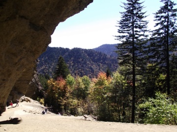
At 2.2 miles hikers will reach Alum Cave, which really isn't a cave, but is actually a concaved bluff, about 80 feet in height, and roughly 500 feet in length. During the warmer months of the year water drips off from the ledges above. In the winter these droplets turn into large icicles.
The first two times we hiked to Alum Cave we were forced to dodge icicles falling from the top of the bluff, some of them as long as three feet. Every couple of minutes an icicle would drop down like an incoming missile and explode on the rocks around us. We were forced to time our entry and exits into the cave in order to avoid shrapnel, or worse yet, a direct hit. Needless to say, extreme caution is needed here during such conditions.
Fortunately we didn't have to worry about icicles during that spring 2008 hike, but we did have to contend with the unusual obstacle of several inches of hail at the base of the bluff. The last 50 feet to the cave is normally a bit of a slog, even with the help of steps. However, on this day, we were forced to advance through enough accumulated hail to have completely buried the steps. It was all worth it though. The views from Alum Cave are always great.
In 2015 the park launched a two-year project to rehabilitate the Alum Cave Trail. Restoration efforts focused on improving hiker safety by repairing cable handrail systems and reinforcing hanging trail sections. Efforts were also made to improve drainage in areas where minor landslides have occurred in the past. As part of this project the park also made changes to the access point into Alum Cave. This involved building a series of steps away from the water seeping over the top of the cave. It appears this will significantly lessen the chances of hikers being hit by icicles.
Alum Cave is rich in history. The Epsom Salts Manufacturing Company was established at Alum Cave in 1838. Until it was sold in 1854, the company mined epsom salt from the cave, which was used by mountain folk to dye homespun clothing a reddish brown. During the Civil War the Confederate Army mined saltpeter from the cave, which was used to manufacture gunpowder.
Just past Alum Cave is Gracie's Pulpit. This landmark is named after Gracie McNichol, who, despite several physical challenges throughout her life, climbed Mount LeConte on 244 occasions, including her last on her 92nd birthday! At roughly 2.6 miles from the trailhead, this small rock outcropping also marks the halfway point to the LeConte Lodge.
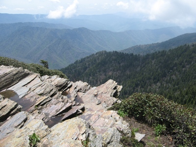
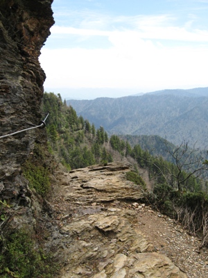
Above Gracie's Pulpit the trail continues by hugging the cliff face. Over the next two miles you'll pass over several narrow rock ledges, many with cable handrails. A few of these ledges pass areas where water seeps out of the rock walls, and requires some careful negotiation to get around - while continuing to grasp onto the cables. On a hot day the cool water that inevitably splashes on you is quite welcome.
My first trek up to Mount LeConte was in the dead of winter. The ledges were frozen solid with snow melt, forcing us to hold onto the cables for dear life. During the warmer months, however, these rock ledges shouldn't present any problems, unless you have an extreme fear of heights. Hikers should note that there are a few sections of trail that are exposed to some fairly steep drop-offs.
The last of these ledges (see photo on right) passes just below Cliff Top (see photo below).
Once beyond this point the trail flattens out and you'll begin passing through a dense spruce-fir forest. At just over 5 miles from the trailhead the Alum Cave Trail dead-ends into the Rainbow Falls Trail. Hikers should turn right here to continue towards the summit.
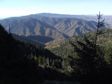
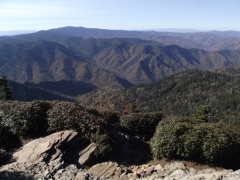
After walking a short distance past the junction you'll arrive at the outskirts of the LeConte Lodge area. A short side trail on the left will lead you down to the main lodge. Many people will be tempted to end their hike here, however, to reach the true summit of Mount LeConte you'll still have to continue for almost another half-mile. If you simply wish to take-in some panoramic views, your best option is to turn right at this junction, which will lead you to Cliff Top, located roughly 0.2 miles further up the mountain.
Before reaching the top of the mountain the Trillium Gap Trail will branch off to your left at roughly 5.2 miles. The summit, better known as High Top, will arrive at the 5.5-mile mark. You'll know you've reached the highest point on the mountain when you reach the large cairn, or pile of rocks, just off the main trail on your right.
At 6593 feet, Mount LeConte is the third highest peak in the Smokies. However, measured from its immediate base to its highest point, Mt. LeConte can be considered the tallest mountain in the Eastern United States, rising 5301 feet from its base near Gatlinburg.
There is considerable controversy over which member of the LeConte family the mountain was named for. Most people, including the U.S. Geological Survey, assume that Joseph LeConte, the famous geologist and charter member of the Sierra Club, is the man for whom the mountain was named for. However, that claim has been challenged in recent years. The authors of the Georgia Encyclopedia, and A Natural History of Mount Le Conte, both claim the name honors Joseph's older brother, John, who was famous as a scientist and as president of the University of California, at Berkeley.
Unfortunately you won't have any vistas from High Top. However, there are two places on the mountain that do afford outstanding panoramic views. One is at Myrtle Point.
To reach Myrtle Point you'll have to walk another 0.4 miles by continuing down the main path, which has now turned into the Boulevard Trail. Roughly 0.2 miles from High Top you'll reach a spur trail on the right side of the trail. After turning onto the spur, walk another 0.2 miles to reach Myrtle Point. This vantage point provides nearly 360-degree views, and is the best location for sunrises on Mt. LeConte.
The other place to visit for outstanding views is Cliff Top, which is located near the LeConte Lodge. You will have passed two side trails that lead to Cliff Top, on your right, as you made your way up to High Top. Cliff Top is the best location for sunset views.
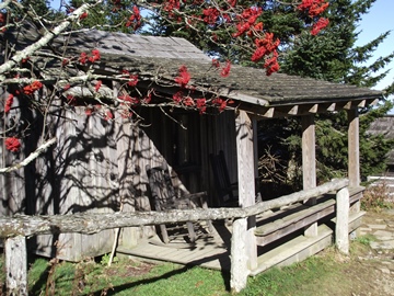
One of the unique aspects about the hike to Mt. LeConte is the lodge and cabins near the top of the mountain. Hikers will have the option of spending the night in one of the historic cabins on the site, which in total can accommodate up to 50 guests a night (you'll need to make reservations well in advance). For more information you can visit the LeConte Lodge website. Hikers may also want to note that the lodge now offers a variety of baked goods, beverages and sack lunches to day hikers.
The idea for the lodge came about when Paul Adams, an enthusiastic hiker and explorer, led an expedition up the mountain with some dignitaries from Washington to show them the rugged beauty of the Great Smoky Mountains, and to help promote the cause for national park status. The group spent the night in a large tent. The following year Adams would build a cabin on that same spot, which eventually led to the establishment of the LeConte Lodge. Adams is also credited with helping to blaze the Alum Cave Trail to the summit of Mount LeConte. My new book on the history of hiking has much more information about trail development in the Smokies, as well as other anecdotal stories from the early years of the park.
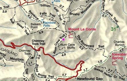
Mt. LeConte (via Alum Cave Trail) Map
Mt. LeConte (via Alum Cave Trail) Elevation Profile
Directions to Trailhead:
This hike to Mt. LeConte in the Great Smoky Mountains begins from the Alum Cave Trailhead. To reach the trailhead from the Sugarlands Visitor Center near Gatlinburg, drive 8.7 miles south along Newfound Gap Road. The parking area will be on your left. Due to the extreme popularity of the Alum Cave Trail, there are actually two parking lots for this trailhead. To ensure a spot you may want to arrive early during peak tourist season, or on any nice weekend throughout the year.