Mt. LeConte (via Bullhead Trail) Highlights
- Trail Features
Panoramic Views
- Trail Location
Roaring Fork Motor Nature Trail
- Roundtrip Length
14.4 Miles
- Elevation Gain (total)
3993 Feet
- Elevation Gain (per mile)
555 Feet
- Trail Difficulty
22.39
Strenuous
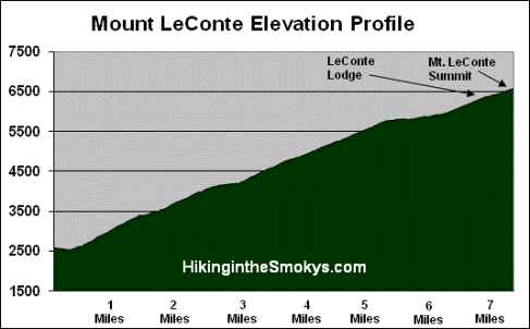
This strenuous hike is 14.4 miles roundtrip and includes 3,993 feet of elevation gain.
Mt. LeConte (via Bullhead Trail) Description
On October 25, 2018 Great Smoky Mountains National Park announced the reopening of the Bullhead Trail after being closed for almost two years due to the November 2016 wildfire. On November 23, 2016 two juveniles started a wildfire near the summit of Chimney Tops. By November 28th the fire grew to 500 acres. After several months of exceptional drought conditions, and winds gusts reaching more than 80 mph that afternoon, the fire literally exploded. Over the next several hours it burned almost 18,000 acres, including 11,410 acres within Great Smoky Mountains National Park. From Chimney Tops the fire raced north, passing around the edges of downtown Gatlinburg and reaching the outskirts of Pigeon Forge. Before it was brought under control the fire killed 14 people, injured more than 176 people, and damaged or destroyed at least 2460 structures at a cost of more than $500 million.
If you're trying to decide between the Rainbow Falls Trail and the Bullhead Trail as to which route to take to the summit of Mt. Le Conte, I would recommend taking the Bullhead Trail because of the views along the way, unless of course you specifically want to see Rainbow Falls. However, because this trail is much more exposed than Rainbow Falls, Bullhead can be a fairly hot hike in the summer, especially along the ridge that leads from Balsam Point to Mount LeConte.
If you're looking to create a loop hike, especially during the summer, I would definitely hike up the Rainbow Falls Trail, and then descend along the Bullhead Trail.
Just before turning into the parking lot you may have noticed a locked gate blocking an old gravel road. This gate marked the old trailhead for the Bullhead Trail. Hikers will have to follow this gravel road, which is actually the Old Sugarlands Trail, for approximately four-tenths of mile before turning left onto the Bullhead Trail.
At just over a mile from the parking lot the trail begins to ascend more rapidly as you climb the Bullhead, a heath-covered bald that extends off Balsam Point. Standing at an elevation of roughly 4300 feet, the bald received its name due to its supposed resemblance to a bulls head from a distance. Over the next mile or so you'll pass several rock cliff faces, and at roughly 1.5 miles from the trailhead, will pass two small caves created by overhanging slabs of rock.
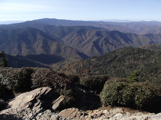
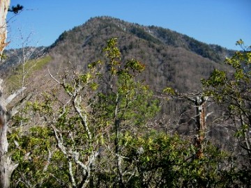
After ascending the west ridge of the Bullhead the trail begins to level out. As you begin traveling along the south side of the mountain the trail also begins to pass through a fairly large burn scar. Almost directly in front you at this point is 5818-foot Balsam Point. Over the course of the next two miles the trail will lead you up the north face of this mountain, before exiting onto the ridge to the right of the mountain (see the photo above).
At almost 3 miles from the trailhead hikers will pass a large cairn that was built by the Civilian Conservation Corps in the mid-1930's. This cairn, informally known as "The Pulpit," was originally known as the Bull Head Lookout, which allowed hikers to stand above the rhododendron and view the mountains towards the east and northeast. As a result of the 2016 wildfire, however, the cairn is no longer needed to enjoy the expansive views that were created after the fire burned the trees and rhododendron that had previously blocked vistas in recent decades.
Hikers will exit Balsam Point and onto the aforementioned ridge at roughly 5.3 miles from the trailhead. Over the next half-mile or so you'll enjoy some great views towards the north. As a result of the wildfire the views are far more expansive than they have been in the past.
At roughly 6.3 miles you'll arrive at the Rainbow Falls Trail junction. Hikers should proceed straight here to continue towards the summit of Mt. LeConte. After walking another four-tenths of a mile you'll reach the Alum Cave Trail, which branches off to the right. Hikers should proceed straight ahead here.
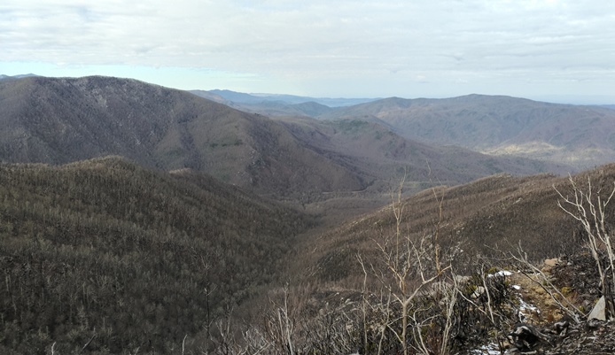
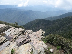
After walking a short distance past the junction you'll arrive at the outskirts of the LeConte Lodge area. A short side trail on the left will lead you down to the main lodge. Many people will be tempted to end their hike here, however, to reach the true summit of Mount LeConte you'll still have to continue for almost another half-mile. If you simply wish to take-in some panoramic views, your best option is to turn right at this junction, which will lead you to Cliff Top, located roughly two-tenths of a mile further up the mountain (see photo below).
Before reaching the summit the Trillium Gap Trail will branch off to your left at 6.9 miles. The summit, better known as High Top, will arrive at the 7.2-mile mark. You'll know you've reached the highest point on the mountain when you reach the huge cairn just off the main trail on your right.
At 6593 feet, Mount LeConte is the third highest peak in the Smokies. However, measured from its immediate base to its highest point, Mt. LeConte can be considered the tallest mountain in the Eastern United States, rising 5301 feet from its base near Gatlinburg.
There is considerable controversy over which member of the LeConte family the mountain was named for. Most people, including the USGS, assume that Joseph LeConte, the famous geologist and charter member of the Sierra Club, is who the mountain was named for. However, that claim has been challenged in recent years. The authors of A Natural History of Mount Le Conte, and the Georgia Encyclopedia, both claim the name honors Joseph's older brother, John, who was famous as a scientist and as president of the University of California, at Berkeley.
Unfortunately you won't have any vistas from High Top. However, there are two places on the mountain that do afford some outstanding panoramic views. One is at Myrtle Point.
To reach Myrtle Point you'll have to walk another 0.4 miles by continuing along the main path, which has now turned into the Boulevard Trail. Roughly 0.2 miles from High Top you'll reach a spur trail on the right side of the trail. After turning onto the spur, walk another 0.2 miles to reach Myrtle Point. This vantage point provides nearly 360-degree views, and is the best location for sunrises on Mt. LeConte.
The other place to visit for outstanding views is Cliff Top, which is located near the LeConte Lodge. You will have passed two side trails that lead to Cliff Top, on your right, as you made your way up to High Top. Cliff Top is the best location for sunset views.
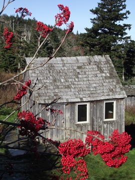
One of the unique aspects about the hike to Mt. LeConte is the lodge and overnight cabins near the top of the mountain. Hikers will have the option of spending the night in one of the historic cabins on the site, which in total can accommodate up to 50 guests a night (you'll need to make reservations well in advance). For more information you can visit the LeConte Lodge website. Hikers may also want to note that the lodge now offers a variety of baked goods, beverages and sack lunches to day hikers.
The idea for the lodge came about when Paul Adams, an enthusiastic hiker and explorer, led an expedition up the mountain with some dignitaries from Washington D.C. to show them the rugged beauty of the Great Smoky Mountains, and to help promote the cause for national park status. The group spent the night in a large tent. The following year Adams would build a cabin on that same spot, which eventually led to the establishment of the LeConte Lodge. Adams is also credited with helping to blaze the trail from Alum Cave to the summit of Mount LeConte.
Mt. LeConte (via Bullhead Trail) Map
Mt. LeConte (via Bullhead Trail) Elevation Profile
Directions to Trailhead:
This hike to Mt. Le Conte in the Smokies begins from the Rainbow Falls Trailhead, located just outside of Gatlinburg. Starting from Light 8 in Gatlinburg, turn onto Historic Nature Trail / Airport Road. After driving 0.7 miles veer right onto Cherokee Orchard Road, where you'll enter Great Smoky Mountain National Park. After driving another 2.2 miles you'll enter the one-way Cherokee Orchard Loop Road. After driving roughly 0.6 miles on the loop, the Rainbow Falls Trailhead will be located on your right. If this parking lot is full there's an auxiliary parking area about a tenth-of-a-mile further down the road.