
Mt. LeConte (via Rainbow Falls Trail) Highlights
- Trail Features
Panoramic Views, Waterfalls
- Trail Location
Roaring Fork Motor Nature Trail
- Roundtrip Length
13.8 Miles
- Elevation Gain (total)
3,993 Feet
- Elevation Gain (per mile)
579 Feet
- Trail Difficulty
21.79
Strenuous
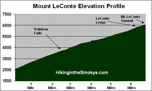
This strenuous hike is 13.8 miles roundtrip and includes 3,993 feet of elevation gain.

Mt. LeConte (via Rainbow Falls Trail) Description
If you're trying to decide between the Rainbow Falls Trail and the Bullhead Trail as to which route to take to the summit of Mt. LeConte, I would recommend taking the Bullhead Trail because of the views along the way, unless of course you specifically want to see Rainbow Falls. However, because the Rainbow Falls Trail is less exposed than Bullhead, the Rainbow Falls Trail might be a little cooler in the summer as you ascend to the summit of Mount LeConte.
If you're planning to create a loop hike, especially in the summer, I would definitely hike up Rainbow Falls Trail and then descend along the Bullhead Trail.
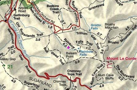
The Rainbow Falls Trail begins near the southeast corner of the parking lot. Over the course of the first two-thirds of a mile you'll climb steadily across a boulder-strewn pathway, while LeConte Creek cascades down the mountain on your right. There are many opportunities for some great picnic sites along this portion of the route.
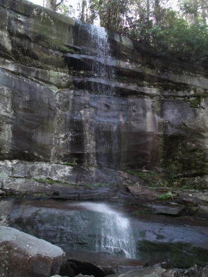
The trail crosses over two footbridges; one at 1.7 miles, and the other just as you reach Rainbow Falls at 2.7 miles. The 80-foot high waterfall is the highest single-drop waterfall in the Smokies. It receives its name from the rainbow that's produced by mist on sunny afternoons. During extended cold periods an impressive ice formation builds around the falls. The falls are best viewed after a long period of rain.
To continue on towards Mount LeConte hikers should cross over the footbridge just below the foot of the falls. Over the next 3.2 miles you'll climb more than 1700 feet to reach the Bullhead Trail junction. This segment of the route travels through rhododendron, sand myrtle, and mountain laurel, which offers hikers beautiful blooms during the spring.
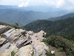
At 5.4 miles you'll arrive at a side trail that shortly loops back to the main trail. This short semi-loop leads to Rocky Spur, an outcropping that offers great views of the Roaring Fork valley.
At just under 6 miles from the trailhead you'll reach the Bullhead Trail junction. Hikers should turn left here to continue towards the summit of Mount LeConte. After walking another four-tenths of a mile you'll arrive at the Alum Cave Trail, which branches off to the right. Hikers should proceed straight ahead here.
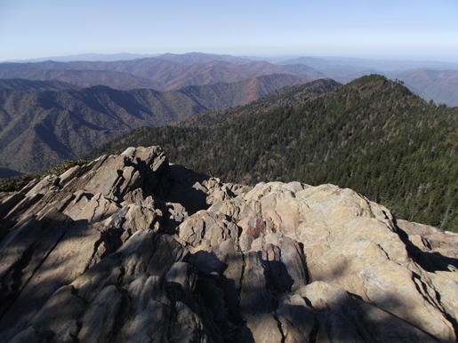
After walking a short distance past the junction you'll reach the outskirts of the LeConte Lodge area. A short side trail on the left will lead you down to the main lodge. Many people will be tempted to end their hike here, however, to reach the true summit of Mount LeConte you'll still have to continue for almost another half-mile. If you simply wish to take-in some panoramic views, your best option is to turn right at this junction, which will lead you to Cliff Top, located roughly two-tenths of a mile further up the mountain (see photo below).
Before reaching the top of the mountain the Trillium Gap Trail will branch off to your left at 6.6 miles. The summit, better known as High Top, will arrive at the 6.9-mile mark. You'll know you've reached the highest point on the mountain when you've reached the large cairn, or pile of rocks, just off the main trail on your right.
At 6593 feet, Mount LeConte is the third highest peak in the Smokies. However, measured from its immediate base to its highest point, Mt. LeConte can be considered the tallest mountain in the Eastern United States, rising 5301 feet from its base near Gatlinburg.
There is considerable controversy over which member of the LeConte family the mountain was named for. Most people, including the USGS, assume that Joseph LeConte, the famous geologist and charter member of the Sierra Club, is who the mountain was named for. However, that claim has been challenged in recent years. The authors of A Natural History of Mount Le Conte, and the Georgia Encyclopedia, both claim the name honors Joseph's older brother, John, who was famous as a scientist and as president of the University of California, at Berkeley.
Unfortunately you won't have any vistas from High Top. However, there are two places on the mountain that do afford some outstanding panoramic views. One is at Myrtle Point.
To reach Myrtle Point you'll have to walk another 0.4 miles by continuing along the main path, which has now turned into the Boulevard Trail. Roughly 0.2 miles from High Top you'll reach a spur trail on the right side of the trail. After turning onto the spur, walk another 0.2 miles to reach Myrtle Point. This vantage point provides nearly 360-degree views, and is the best location for sunrises on Mt. LeConte.
The other place to visit for outstanding views is Cliff Top, which is located near the LeConte Lodge. You will have passed two side trails that lead to Cliff Top, on your right, as you made your way up to High Top. Cliff Top is the best location for sunset views.
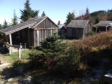
One of the unique aspects about the hike to Mount LeConte is the lodge and cabins near the top of the mountain. Hikers will have the option of spending the night in one of the historic cabins on the site, which in total can accommodate up to 50 guests a night (you'll need to make reservations well in advance). For more information you can visit the LeConte Lodge website. Hikers may also want to note that the lodge now offers beverages, sack lunches, and a variety of baked goods to day hikers.
The idea for the lodge came about when Paul Adams, an enthusiastic hiker and explorer, led an expedition up the mountain with some dignitaries from Washington to show them the rugged beauty of the Great Smoky Mountains, and to help promote the cause for national park status. The group spent the night in a large tent. The following year Adams would build a cabin on that same spot, which eventually led to the establishment of the LeConte Lodge. Adams is also credited with helping to blaze the trail from Alum Cave to the summit of Mount LeConte.
Mt. LeConte (via Rainbow Falls Trail) Map
Mt. LeConte (via Rainbow Falls Trail) Elevation Profile
Directions to Trailhead:
This hike to Mt. LeConte in the Smokies begins from the Rainbow Falls Trailhead, located just outside of Gatlinburg. Starting from Light 8 in Gatlinburg, turn onto Historic Nature Trail / Airport Road. After driving 0.7 miles veer right onto Cherokee Orchard Road, upon which you'll enter into Great Smoky Mountain National Park. After driving another 2.2 miles you'll enter the one-way Cherokee Orchard Loop Road. After driving roughly 0.6 miles on the loop, the Rainbow Falls Trailhead will be located on your right. If this parking lot is full, there's an auxiliary parking area about a tenth-of-a-mile further down the road.