Lonesome Pine Overlook Highlights
- Trail Features
Outstanding Views
- Trail Location
Deep Creek
- Roundtrip Length
6.7 Miles
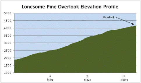
- Elevation Gain (total)
2300 Feet
- Elevation Gain (per mile)
511 Feet
- Trail Difficulty
11.30
Strenuous
This strenuous hike is 6.7 miles roundtrip and includes 2300 feet of elevation gain.

Lonesome Pine Overlook Description
The Noland Divide Trail begins as a steady climb as it skirts along the southern boundary of Great Smoky Mountains National Park. Throughout the lower elevations of the hike you'll pass through a mixed, new-growth forest. As you climb higher, views of the surrounding mountains, including your destination, become more prevalent.
At roughly 1.6 miles from the trailhead you'll pass a nice cascade tumbling down the hillside.
At roughly 3 miles, as you walk along the narrow Beaugard Ridge, the Lonesome Pine Overlook will be almost directly in front of you. The trail actually circles around to the backside of the knob where you'll see a sign for the short spur trail that leads to the top of the overlook.
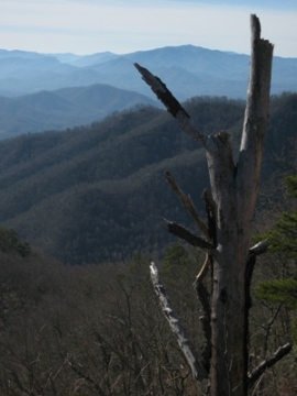
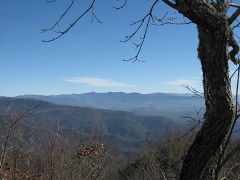
This is an outstanding hike if you're seeking a little bit of solitude and some outstanding views of the Southern Smokies. The area surrounding the Lonesome Pine Overlook offers commanding views of the Nantahala Mountains across the Tuckasegee River Valley, as well as Bryson City almost directly below you. Although the name of the knob would seem to indicate unimpeded views, there are actually several trees that get in the way of a perfect vantage point. Actually, the narrow ridgeline just below the summit offers better views of the mountains to the east and towards the west.
I should also mention that there are a few sections of trail, on the top half of the hike, where the path is fairly narrow with exposure to some steep drop-offs. There's nothing exceedingly dangerous here, just a word of caution.
From the Lonesome Pine Overlook the Noland Divide Trail continues for another 8.3 miles to Clingmans Dome Road. An overnight loop hike could be created by continuing northbound on the Noland Divide Trail, turning east onto Pole Road Creek Trail, and then returning back to the trailhead via the Deep Creek Trail. There are several backcountry campsites located on the Deep Creek Trail that will provide a few options.
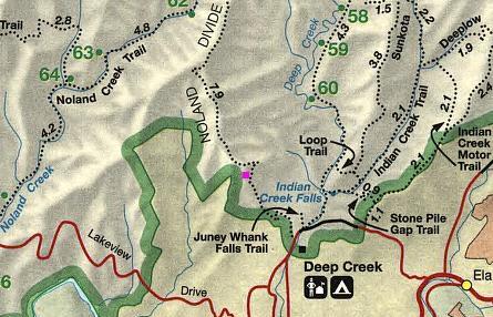
Lonesome Pine Overlook Map
Lonesome Pine Overlook Elevation Profile
Directions to Trailhead:
The hike to the Lonesome Pine Overlook begins from the Noland Divide Trailhead in the Deep Creek area of the Smokies, located just north of Bryson City, North Carolina. To reach the trailhead from the intersection of Rt. 441 and Rt. 19 in Cherokee, drive 10 miles south on Route 19 to Everett Street in Bryson City. Turn right onto Everett and drive for 0.2 miles, and then turn right onto Depot Street. After a short distance, take a left onto Ramseur Street, and then make an immediate right onto Deep Creek Road and drive another 2.3 miles to the park entrance. The Noland Divide Trailhead will be located on the left, across from the bridge that leads into the Deep Creek Campground