Lumber Ridge Trail Highlights
- Trail Features
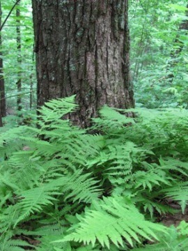
Quiet Forest Hike, Solitude
- Trail Location
Tremont
- Roundtrip Length
8.1 Miles
- Elevation Gain (total)
1524 Feet
- Elevation Gain (per mile)
376 Feet
- Trail Difficulty
11.15
Strenuous
This strenuous hike is 8.1 miles roundtrip and includes 1524 feet of elevation gain.

Lumber Ridge Trail Description
From the parking area hikers should walk up the gravel road and turn left just before reaching the GSMIT dormitory building. The trailhead is located only a few yards from the building.
Tremont, located in the Walker Valley, is named after the small lumber town that developed when the Little River Lumber Company used this area as a base of operations. The name is derived from the combination of "tree" and "mountain."
Tremont was one of the last areas in the park to be logged. This was a result of Will Walker's refusal to sell his property to the Little River Lumber Company. However, after a stroke that left him largely incapacitated, Walker was forced to finally sell his property in 1918. Logging operations would continue in the valley until 1938 - four years after the formation of the Smokies as a national park. This was permitted as a result of Colonel Wilson B. Townsend selling his Little River tract to the Great Smoky Mountains National Park Commission in 1926, in exchange for an agreement that allowed him to continue logging in the area for another 15 years.
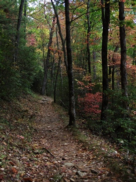
The Lumber Ridge Trail is the perfect hike if you're looking for a little peace, quiet and solitude. Although the name "Lumber Ridge" likely comes from the logging operations in this area, the name of the trail is quite appropriate for modern day hikers who wish to "lumber" along with no particular destination or goal in mind.
The only noise we heard during our most recent hike was the chatter of song birds, and the occasional staccato of woodpeckers.
After walking only a few yards up the trail hikers will reach the Buckeye Trail, which leads to Spruce Flats Falls, located roughly seven-tenths of a mile from the junction. Neither the waterfall nor this spur trail appears on the official park map. To continue towards Buckhorn Gap hikers should proceed straight ahead at this junction.
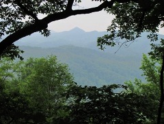
At just over a mile from the trailhead you'll begin to notice occasional views of the surrounding mountains as they appear through the trees.
If you're planning to hike this trail in late May or early June, you'll also be treated to a fair amount of blooming azaleas along the way.
After climbing steadily over the course of the first 2.4 miles, hikers will finally reach the top of Lumber Ridge. You'll likely notice a faint "social" path crossing over the main trail here. Hikers should proceed straight ahead at this intersection by following the main trail as it leads down the opposite side of the ridge.
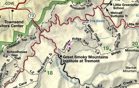
At just over 4 miles hikers will reach Buckhorn Gap where the trail intersects with the Meigs Creek and Meigs Mountain trails. This is the turnaround point for this out-and-back hike. However, if you're in a group with multiple vehicles you could arrange a one-way, 7.6-mile hike from Tremont to the Sinks area off Little River Road, by heading north along the Meigs Creek Trail. Two other options for hikers looking for one-way hikes are to continue on towards Metcalf Bottoms via the Curry Mountain Trail, or you could take the Meigs Mountain Trail all the way to Elkmont. Backpackers could also use Campsites 19 and 20 to create an overnight trip.
Lumber Ridge Trail Map
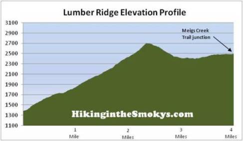
Lumber Ridge Trail Elevation Profile
Directions to Trailhead:
The hike along the Lumber Ridge Trail in the Great Smoky Mountains begins from the Lumber Ridge Trailhead in Tremont. To reach the trailhead from the from the Townsend "Y" intersection, drive west on Laurel Creek Road towards Cades Cove. Roughly two-tenths of a mile from the "Y", turn left to proceed towards the Great Smoky Mountains Institute at Tremont. Drive another two miles and turn left into the Great Smoky Mountains Institute. After driving across the narrow bridge, look for a small parking area on the right. The Lumber Ridge Trailhead is located along the gravel road just beyond the parking area.