Meigs Mountain Trail Highlights
- Trail Features
Quiet Forest Hike, History
- Trail Location
Elkmont
- Roundtrip Length
4.6 Miles
- Elevation Gain (total)
661 Feet
- Elevation Gain (per mile)
287 Feet
- Trail Difficulty
5.92
Moderately Difficult
This moderately difficult hike is 4.6 miles roundtrip and includes 661 feet of elevation gain.

Meigs Mountain Trail Description
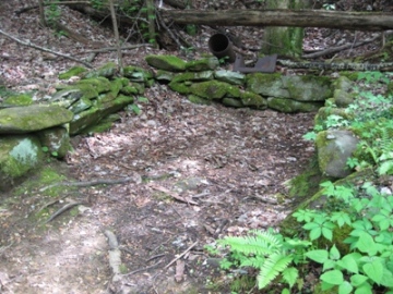
From the fairly large parking area, walk through the gate on the far end of the road to begin your hike along the Jakes Creek Trail. Almost immediately you'll begin passing the remnants of several old cottages. Most of these cottages were built in the 1920s, and were used as summer homes by the affluent from the Knoxville area. As of this writing most of the homes along this trail have been razed by the National Park Service. The only artifacts that remain are the chimneys, stone walls, and a few other rock structures that were once part of these homes. The former home of Colonel David C. Chapman also survives, and appears to be one of the few structures that will be preserved and fully restored by the park (see photo on right). Colonel Chapman played an instrumental role in the establishment of Great Smoky Mountains National Park. According to National Park Service documents, the Great Smoky Mountains plans to fully restore 19 structures in the Elkmont District so that they can be opened and viewed by the public. As part of the first phase of the Elkmont restoration project, the National Park Service reopened the old Appalachian Clubhouse for public rental in June of 2011.
After walking roughly one-third of a mile along the old gravel road the Cucumber Gap Trail will branch off towards the left. Hikers should continue by proceeding straight ahead here. A short distance from this junction is the Meigs Mountain Trail. Hikers will have the option of continuing up the Jakes Creek Trail for less than a half-mile to visit the Avent Cabin. To proceed along the Meigs Mountain Trail you should veer right at this junction.
The trail and nearby mountain are named after Colonel Return Jonathan Meigs, a Revolutionary War veteran, surveyor, agent to the Cherokee Nation, and military agent for the United States War Department. Meigs reportedly hung a bright-colored blanket atop a mountain towards the south, now known as Blanket Mountain, for use as a compass reference point.
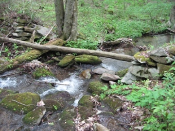
At roughly six-tenths of a mile from the trailhead hikers will reach Jakes Creek. Just upstream from the footbridge is a small waterfall.
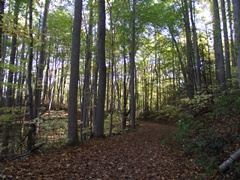
From this point the trail travels over relatively flat terrain as it meanders along the contours of Blanket Mountain. During our most recent hike we noticed quite a few yellow trillium, violets and Virginia bluebells along this section of trail. You'll also pass evidence of some of the former inhabitants of this area as well.
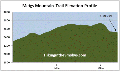
This particular hike ends at the remains of an old dam. Before reaching it, the trail descends roughly 200 feet in just one-third of a mile. At the bottom of the hill you'll pass by Backcountry Campsite 20, as well as two small streams. At a third stream, known as Blanket Creek, there will be a small dam, which marks the final destination for this hike.
One explanation I've heard for the dam is that it was used to help keep milk and butter cool during the summer months for the settlers in this area. Another explanation is that splash dams were built by loggers to help move logs downstream. There's a large piece of scrap metal near the site, which indicates to me that the later explanation might be the correct one.
Hikers will have the option of continuing along the Meigs Mountain Trail for another 1.3 miles to reach the Curry Mountain Trail junction; or hiking all the way to the end of the trail at the junction with the Meigs Creek Trail and Lumber Ridge Trail, roughly 3.9 miles further to the west.
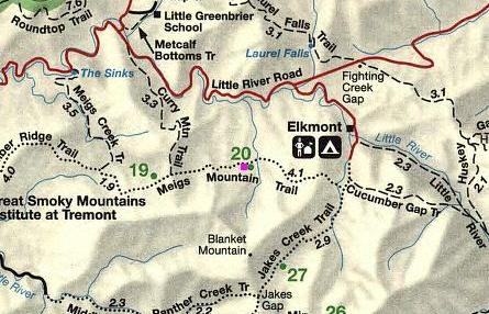
Meigs Mountain Trail Map
Meigs Mountain Trail Elevation Profile
Directions to Trailhead:
The hike along the Meigs Mountain Trail in the Great Smoky Mountains begins from the Jakes Creek Trailhead in Elkmont. To reach the trailhead from the Sugarlands Visitor Center near Gatlinburg, drive 4.9 miles west along the Little River Road to the turnoff for the Elkmont Campground, which will be on your left. After turning into Elkmont, drive 1.4 miles to reach the campground entrance. Instead of proceeding into the campground, turn left and drive another 0.8 miles to the parking area for the Jakes Creek Trailhead at the end of the road. The Jakes Creek Trail will provide access to the Meigs Mountain Trail.
From the Townsend "Y" intersection near Cades Cove, the turnoff for the Elkmont Campground will be 12.6 miles away.