Mingus Creek Trail Highlights
- Trail Features
Historic, Wildflowers, Stream
- Trail Location
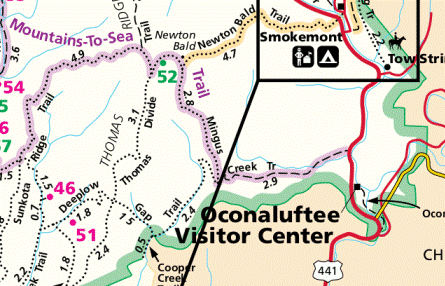
Mingus Mill Parking Lot
- Roundtrip Length
5.8 Miles
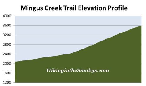
- Elevation Gain (total)
1515 Feet
- Elevation Gain (per mile)
522 Feet
- Trail Difficulty
8.83
Moderately Difficult
This moderately difficult hike is 5.8 miles roundtrip and includes 1515 feet of elevation gain.
Mingus Creek Trail Description
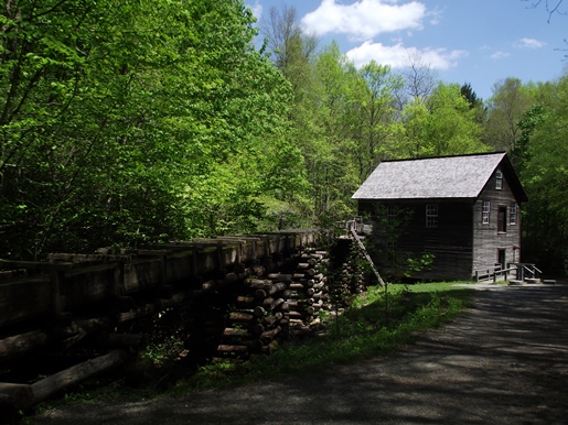
The Mingus Creek Trail begins from the parking area for the historic Mingus Mill. Although not technically on the trail, this is a must-see stop before proceeding on your hike.
Built in 1886, the historic grist mill has the distinction of being driven by a water-powered, cast iron turbine, rather than a water wheel, which was far more common during that era. The mill is still in operation today, and from mid-March through mid-November visitors can take tours and purchase cornmeal that's been ground on the site.
The trail and the mill both take their name from John Jacob Mingus (circa 1774-1852). Mingus arrived in the Oconaluftee valley in the 1790s, and was the first Euro-American to settle within the boundaries of what is now Great Smoky Mountains National Park.
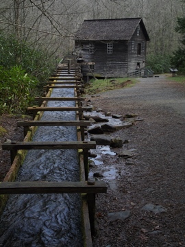
After traveling roughly one tenth-of-a-mile along the trail, hikers will reach the point where the mill begins diverting water from Mingus Creek. At first the water flows through a moss-covered sluice. Then, as the elevation drops, the water begins flowing to the mill along a raised millrace.
At roughly four tenths-of-a-mile from the trailhead hikers will pass the park ranger shooting range.
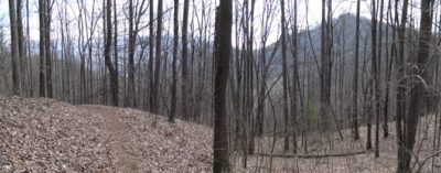
Over the course of the first mile or so the trail is actually an old road bed, built by the Civilian Conservation Corps in the 1930s. It also passes through a very pleasant new-growth forest with lots of rhododendron along the way. During our early spring hike we also saw a fair amount of white trillium, blue phlox, violets, Virginia bluebells and a few other wildflower varieties we couldn't identify.
The entire length of the Mingus Creek Trail also follows the Mountains-to-Sea Trail, a footpath that stretches roughly 1,150 miles, from Clingmans Dome to Jockey's Ridge on the Outer Banks of the North Carolina coast.
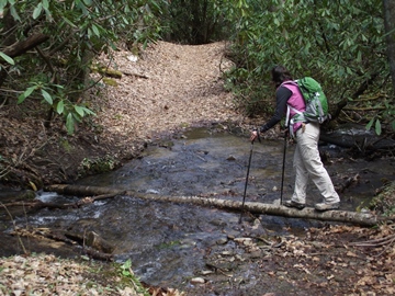
After about a mile of walking along fairly easy terrain the trail begins to narrow and becomes rockier. Soon after you'll pass over two small footbridges, and shortly thereafter will arrive at a fork in the trail. The side trail to the right leads to an old family cemetery along Mingus Creek. To continue on towards Deeplow Gap you should stay to the left on the main trail, which now begins following the Madcap Branch.
Just beyond this trail junction hikers will reach a creek crossing that could pose a little bit of a challenge after a period of heavy rain. The water's not deep; however, there are rocks and a log that will help you get across, though they were a little slick. You'll definitely want to bring along walking sticks during these conditions. As the trail climbs higher you'll pass over five more creek crossings without the benefit of a footbridge. None of these should be an issue. If you're able to make it across the first one, the next five shouldn't be a problem.
Over the last three quarters-of-a-mile or so on the way to the gap the trail makes a fairly steep climb along a series of switchbacks.
At 2.9 miles from the trailhead hikers will finally reach Deeplow Gap. Before the trees leaf out in the spring you'll have some decent views of the surrounding mountains, but nothing exceedingly noteworthy. This hike description ends here, but you will have the option of taking the Deeplow Gap Trail down to the Cooper Creek Trail or Thomas Divide Trail. You could also continue on the Mingus Creek Trail as it travels up to Newton Bald. This would add another 2.8 miles, and another 1460 feet of climbing to your one-way hike.
Mingus Creek Trail Map
Mingus Creek Trail Elevation Profile
Directions to Trailhead:
The Mingus Creek Trailhead is at the far end of the parking area for the Mingus Mill, which is located about a half-mile north of the Oconaluftee Visitor Center on the North Carolina side of the Smokies.