Mt. Rogers NRA / Grayson Highlands S.P.
Mount Rogers National Recreation Area:
The Mount Rogers National Recreation Area is located within the Jefferson National Forest in southwestern Virginia. The centerpiece of the recreation area is Mount Rogers, the highest point in the state of Virginia, which tops out at an elevation of 5729 feet.
Established in 1966, the Mt. Rogers NRA features more than 400 miles of trails that range from primitive dirt footpaths, to old logging roads and railroad grades. Although most trails are foot traffic only, there are some that allow horses and/or bicycles. If you're looking for solitude you should note that many of the trails in the high country are very popular destinations, especially on the weekends. This includes the Virginia Creeper Trail and the Appalachian Trail.
 In addition to the Appalachian Trail and the Virginia Creeper Trail (hiking, biking and horseback riding), another popular route is the Virginia Highlands Horse Trail, which, at more than 50 miles in length, connects with several other trails in the area and provides hikers with several loop opportunities.
Some of the other popular trails in the Mount Rogers National Recreation Area include the Comers Creek Falls Trail, the Hale Lake Trail, as well as the Raven Cliff Furnace Trail, a short footpath that leads to a Civil War era iron furnace.
Grayson Highlands State Park:
Bordering Mount Rogers NRA to the south is Grayson Highlands State Park. Located roughly midway between Independence and Damascus on U.S. 58, Grayson Highlands State Park was established in 1965, and was originally known as Mount Rogers State Park.
 Grayson Highlands offers nine hiking trails that lead to panoramic vistas and scenic waterfalls, as well as a 200-year-old pioneer cabin. Hikers will also have access to the Appalachian Trail, as well as trails in the surrounding Jefferson National Forest.
One of my absolute favorite hikes in the Southern Appalachians travels along the Appalachian Trail to the summit of Mt. Rogers.
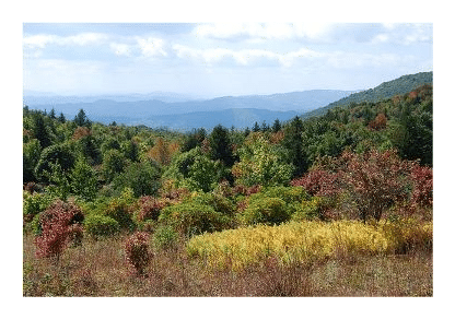
Nearly the entire length of the four-mile (one-way) hike passes through open country, and offers sweeping views of the surrounding wilderness as far as the eye can see. With the rocky outcroppings and the wide open views, in many ways it feels more like hiking out west rather than the Appalachian Mountains.
Although a handful of peaks in the Appalachian Mountains have higher elevations, Mount Rogers lays claim to being the highest state highpoint east of South Dakota that doesn't have a road leading to its summit.
My wife and I had the pleasure of hiking to the summit of Mt. Rogers on two recent occasions. Both times we started our hike from Massie Gap in Grayson Highlands State Park.
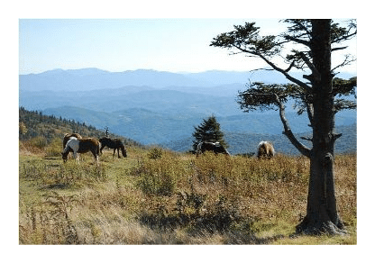
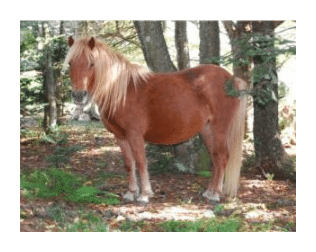 To reach the summit from Massie Gap (elevation 4650 feet) we took the Rhododendron Trail. At first the trail leads across an open field, and then follows an old wagon road over a hillside. On both of our hikes it was in this area that we began to see some of the wild ponies for which this area is famous for. In addition to mechanical clearing with chainsaws, grazing cattle, and use of carefully controlled fires, the U.S. Forest Service uses the ponies to keep the popular balds open.
After about a half-mile we turned onto the Appalachian Trail, which led us up the rugged and rocky outcroppings of Wilburn Ridge, and then through Rhododendron Gap. From Rhododendron Gap it's an easy one-and-a-half-mile hike to the short spur trail that leads to the summit, which is located just past the Thomas Knob Shelter. This section of trail is simply spectacular. The best views and the most beautiful scenery are found along this stretch of trail.
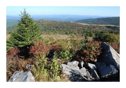 Upon turning onto the half-mile spur trail to the summit, we finally reached the tree-line. Unlike most mountains, the forest in this area of the highlands still claims the highest elevations. The 5729-foot summit of Mount Rogers is covered by a thick spruce-fir forest, which means you won't have any views there, and is the only place on the entire hike where you'll hike amongst the trees.
If you're anywhere near this part of the country, I would highly recommend taking the opportunity to hike this incredibly scenic trail.
In addition to the hundreds of miles of hiking trails, both Grayson Highlands State Park and the Mount Rogers National Recreation Area offer mountain biking, horseback riding, fishing, canoeing and cross-country skiing. Frontcountry and backcountry camping are also offered within the two areas as well.