Porters Creek Trail Highlights
- Trail Features
Waterfall, History, Wildflowers, Stream
- Trail Location
Greenbrier
- Roundtrip Length
4.0 Miles
- Elevation Gain (total)
699 Feet
- Elevation Gain (per mile)
350 Feet
- Trail Difficulty
5.4
Moderately Difficult
This moderately difficult hike is 4.0 miles roundtrip and includes 699 feet of elevation gain.
Porters Creek Trail Description
The first mile of the Porters Creek Trail is actually an old gravel road, which meanders through a lush forest of moss covered trees and rocks as it follows along the banks of Porters Creek. If you happen to have the opportunity to hike this trail during the spring you'll likely be treated to an absolutely awesome display of yellow trillium near the trailhead.
Roughly two-thirds of a mile from the trailhead several old stone walls will appear on your right. These are remnants from the Elbert Cantrell farmstead, who settled in the Porters Creek community in the early 1900s. Also on your right, just past the stone walls, is the Ownby Cemetery, which also dates back to the early part of the 20th century.
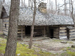
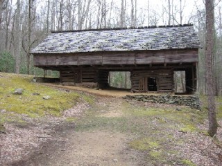
Roughly one mile from the trailhead, after crossing over a footbridge, hikers will reach a fork in the road. The spur trail on the right leads to an historic farm site. A short hike of roughly 250 yards will take you to the John Messer farm site, which includes a cantilevered barn that was built by John Whaley around 1875. There's also a cabin on this site that was built by the Smoky Mountain Hiking Club in the mid-1930s. Members of the club were permitted to use the cabin as an overnight facility until 1981.
To continue towards Fern Branch Falls you should veer left at this junction. Hikers will then walk another hundred feet or so to arrive at the Brushy Mountain Trail junction. To continue along the Porters Creek Trail hikers should turn left here as well.
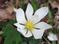
The old gravel road finally turns into a dirt footpath at this point. You'll also begin to notice some much larger old-growth trees as you proceed further upstream. At 1.6 miles hikers will cross a second footbridge. It was past this bridge that we began seeing a profusion of wildflowers. The forest floor was literally carpeted with bloodroot, hepaticas, white fringed phacelia, violets, white trilliums and many other varieties during our late-March hike.
As the season progresses into April and May you'll be able to find yellow trillium, toothwort, wild geranium, May-apple, dwarf ginseng, blue phlox, baneberry, foam flower, halberd-leaved violets, woodland bluets and Jack-in-the-pulpits along this route as well.
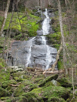
At roughly 2 miles hikers will arrive at the 60-foot Fern Branch Falls, which drops off the ridge on the left side of the trail. During high water flows this can be a fairly spectacular waterfall. Although this particular hike ends at this point, the trail continues on for another 1.7 miles to reach Backcountry Campsite 31.
While this a great option for a hike at any time of the year, the Porters Creek Trail is also an excellent choice when snow makes foot travel difficult in the higher elevations, or when it forces the closure of roads throughout other parts of the park.
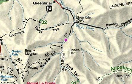
Porters Creek Trail Map
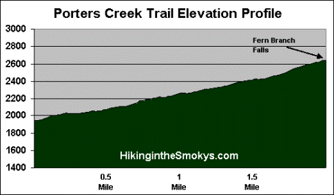
Porters Creek Trail Profile
Directions to Trailhead:
The hike along the Porters Creek Trail in the Great Smoky Mountains begins from the Porters Creek Trailhead in Greenbrier. To reach the trailhead from the junction of 441 and 321 in Gatlinburg (Light 3), turn to travel eastbound on 321. Drive 6 miles and turn right into Greenbrier (look for the Great Smoky Mountains National Park entrance sign on the right). This road turns into a gravel road after a short distance. From Route 321 drive 3.1 miles to a fork in the road. Continue straight ahead at this junction to reach the Porters Creek Trailhead. The parking area for the trail will be almost another mile from this junction.