Rainbow Falls Highlights
- Trail Features
Waterfalls, Old growth forests
- Trail Location
Roaring Fork Motor Nature Trail
- Roundtrip Length
5.4 Miles
- Elevation Gain (total)
1685 Feet
- Elevation Gain (per mile)
624 Feet
- Trail Difficulty
8.77
Moderately Difficult
This moderately difficult hike is 5.4 miles roundtrip and includes 1685 feet of elevation gain.
Rainbow Falls Description
The first two-thirds of a mile along the Rainbow Falls Trail is a steady climb through a large boulder field. As you proceed through this area LeConte Creek will cascade down the mountain on your right. Hikers will find several great picnic sites along this stretch of trail.
Over the decades the Rainbow Falls Trail has gained a reputation for being a rough and rugged footpath due to the terrain it passes through. In 2017 the park addressed the situation by launching a major, two-year project to rehabilitate the trail and improve hiker safety. The main objectives of the project were to stabilize eroding sections of trail, and repair trail tread damaged by high winds and fire during the Chimney Tops 2 wildfire in November of 2016. In all, work crews installed over 350 steps through steep, narrow corridors, created nearly 600 feet of elevated trail surfaces, installed nearly 400 drainage elements, and placed over 1000 native stones along the route to create a durable and sustainable trail corridor. The rehabilitation project also eliminated numerous, visitor-created side trails - more than a mile in length - which created erosion and much confusion for hikers.
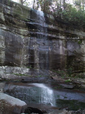
As you continue up the LeConte Creek valley hikers will cross over two footbridges along the way; one at 1.7 miles, and the other just as you reach the 80-foot high waterfall, located roughly 2.7 miles from the trailhead.
Rainbow Falls has the distinction of being the highest single-drop waterfall in the Smokies. The name for the waterfall comes from the rainbow that's produced by mist on sunny afternoons. During extended cold periods an impressive ice formation builds around the waterfall.
The falls are best viewed after long periods of rain. If you wish to go home with some great photos I highly recommend starting your hike first thing in morning, or in the later afternoon. During the late morning and early afternoon time period the sun will be directly over the waterfall, which will make photographing a challenge.
Hikers should note that the rocks around the falls are quite slippery due to mist and algae. As a result, the park warns visitors not to climb on rocks near any waterfall. Over the years several people have fallen to their deaths, while many others have suffered serious injuries.
From Rainbow Falls the hiking trail continues to the summit of Mt. LeConte. If you still have the energy you could extend your hike for another 4.2 miles to reach the top of the third highest mountain in the Great Smoky Mountains.
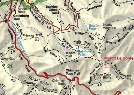
Rainbow Falls Map
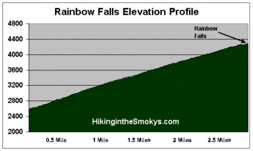
Rainbow Falls Elevation Profile
Directions to Trailhead:
The hike to Rainbow Falls in the Great Smoky Mountains begins from the Rainbow Falls Trailhead, located just outside of Gatlinburg. Starting from Light 8 in Gatlinburg, turn onto Historic Nature Trail / Airport Road. After driving 0.7 miles veer right onto Cherokee Orchard Road, upon which you'll enter into Great Smoky Mountain National Park. After driving another 2.2 miles you'll enter the one-way Cherokee Orchard Loop Road. After driving roughly 0.6 miles on the loop, the Rainbow Falls Trailhead will be located on your right. If this lot is full, there's an auxiliary parking area about a tenth-of-a-mile further down the road.