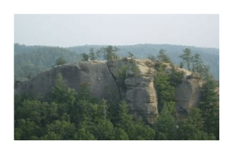
The Red River Gorge Geological Area
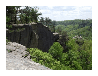
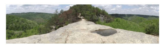
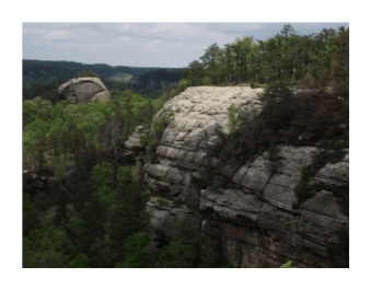
The Red River Gorge is a unique and scenic natural area within the Daniel Boone National Forest in eastern Kentucky - roughly one hour east of Lexington. Known for its abundant natural stone arches, unusual rock formations, and spectacular sandstone cliffs, the Red River Gorge was designated as a Geological Area by the Forest Service in 1974. As a result of its abundance of cliffs, rock climbers from all over the world have discovered first class climbing in the Gorge. And with over 100 natural arches within its boundaries, the Red River Gorge Geological Area has the greatest concentration of arches east of the Rocky Mountains.
The Red River Gorge was almost permanently lost as a hiker's paradise back in the early 1960s. In order to stop the periodic flooding of towns downstream, the Army Corp of Engineers proposed to build a dam on the Red River, which would've transformed the entire Gorge into a large lake. The battle to "Save the Red River Gorge" lasted for decades, and included a Dam Protest Hike on November 18, 1967. Participating in this hike was Supreme Court Justice William O. Douglas, who helped to draw national attention to the situation.
The battle to save the Gorge was effectively won when a portion of the Red River was designated as a National Wild and Scenic River on December 3, 1993. This nine-mile stretch of river, located upstream from the confluence of Copperas Creek, was also the first National Wild and Scenic River in Kentucky.
With passage of the Kentucky Wilderness Act of 1985, the U.S. Congress designated roughly half of the 26,000-acre Gorge area as the Clifty Wilderness, which encompasses the area located east of Highway 715, and to the northeast of the Gladie Historic Site.
In 2003, the Red River Gorge, Clifty Wilderness, and Indian Creek areas were designated as a National Archaeological District, and placed on the National Register of Historic Places due to the pre-historic peoples that lived in the region.
 The complex topography of Red River Gorge provides habitat for a rich diversity of plants and animals. Visitors will find maples, oaks, tulip poplar, pine, ash, walnut and eastern hemlocks among the many species of trees that grow here. There are also many wildflowers to be found here as well, including Bloodroot, Hepatica, Trillium, Purple Phacelia, Crested Dwarf Iris, and Pink and Yellow Lady's Slippers, just to name a few. Some of the trails known for outstanding spring wildlfowers include Swift Camp Creek, Wildcat, Rock Bridge, Whittleton Branch and Whittleton Arch.
With more than 100 species calling Red River home for at least part of the year, outdoor enthusiasts will find a wide variety of birds. Hawks, owls, woodpeckers, vireos, hummingbirds, indigo bunting, as well as several species of warblers, are among the birds that can be found in the Gorge.
 If you're lucky enough, you might spot a deer, turkey, fox, coyote, or even a bobcat. After many years of rumors and speculation, black bears have recently been confirmed in the Red River Gorge.
Finally, Red River Gorge is also widely known for the Nada Tunnel, a 900-foot, 12' x 12' tunnel along Kentucky 77. The one-lane tunnel provides an interesting and unique way to enter and exit the Geological Area.
Nada Tunnel, and the small community of Nada, were named for the Dana Lumber Company. In the early 1900s the logging company built the tunnel in order to haul logs out of the Gorge by railroad. The tunnel is now listed on the National Register of Historic Places.
Hiking in Red River Gorge
Hikers should be extremely careful while hiking in Red River Gorge. Each year 1 or 2 people fall to their deaths in the Gorge because they don't exercise proper caution among the many cliffs in the area.
A couple of trails that I highly recommend, that will give you a broad flavor for the Gorge area, include the Auxier Ridge, Chimney Top, Sky Bridge, Gray's Arch and Rock Bridge trails.
Below is a full list of trails, which include trail names, national forest trail number, and one-way mileage. Due to the way the trail system is set-up in Red River Gorge, many of the destinations require a combination of trails. For instance, Trail #5, Gray's Arch, is only 0.3 miles in length. However, this trail doesn't pass by its namesake. You must turn onto the Rough Trail for another 0.6 miles in order to reach Gray's Arch. Many of the trails listed below can be combined to create a variety of loop hikes.
Angel Windows (#218) 0.3 miles
Auxier Branch (#203) 0.8 miles
Auxier Ridge Trail (#204) 2.0 miles
Bison Way (#210) 0.4 miles
Buck (#226) 1.5 miles
Chimney Top Trail (#235) 0.3 miles
Cliff (#206) 0.4 miles
Court House Rock (#202) 2.4 miles
Daniel Boone Hut (#209) 0.7 miles
Double Arch (#201) 2.1 miles
Gray's Arch (#205) 0.3 miles
Hidden Arch (#208) 1 miles
Koomer Ridge (#220) 2.3 miles
Princess Arch (#233) 0.2 miles
 Rock Bridge (#207) 1.3 miles
Rough Trail (#221) 6.6 miles
Rush Ridge (#227) 1 mile
Silvermine Arch (#225) 1.3 miles
Silvermine Spur (#225S) 0.1 miles
Sky Bridge (#214) 0.8 miles
Swift Camp Creek (#219) 6.7 miles
Tower Rock (#229) 0.4 miles
Whistling Arch (#234) 0.2 miles
Whittleton Branch (#217) 0.2 miles
Wildcat (#228) 1.7 miles
Sheltowee Trace National Recreation Trail
The Sheltowee Trace is a 282-mile multi-use trail that passes through Red River Gorge while traversing the length of the Daniel Boone National Forest. The trail is named in honor of Daniel Boone. Sheltowee (meaning Big Turtle) was the name given to Boone when he was adopted into the Shawnee Indian tribe as the son of the great war chief, Blackfish. Boone made several explorations throughout the area that is now the Daniel Boone National Forest, in search of a route from Virginia to Kentucky.
Completed in 1976, the Sheltowee Trace was designated as the 100th National Recreation Trail in 1979. Along its route hikers pass waterfalls, arches, panoramic ridge-top views and massive sandstone cliffs.
 The entire length of the National Recreation Trail runs from Highway 377 north of Morehead, Kentucky, to Picket State Park in Tennessee. Along the way it passes through Cave Run Lake, Natural Bridge State Park, Laurel River Lake, Cumberland Falls State Resort Park, several wildlife management areas, as well as the Big South Fork National River and Recreation Area. All but 10 miles of the entire trail is located within Kentucky.
In Red River Gorge, the path traverses 11 miles from the northern boundary to Natural Bridge State Park in the south. At roughly the half-way point, hikers must use a swinging bridge to cross the Red River.
Key Links:
USDA Forest Service: General Information
Hiking and Backpacking in Red River Gorge