Rich Mountain Loop Highlights
- Trail Features
Views, Wildflowers, History
- Trail Location
Cades Cove
- Roundtrip Length
8.5 Miles
- Elevation Gain (total)
1736 Feet
- Elevation Gain (per mile)
408 Feet
- Trail Difficulty
11.97
Strenuous
This strenuous hike is 8.5 miles roundtrip and includes 1736 feet of elevation gain.
Rich Mountain Loop Description
Do you hate sitting in Cades Cove Loop Road traffic? If so, the Rich Mountain Loop just might be the perfect hike for enjoying the beauty of Cades Cove - without having to waste a lot of time sitting in 11 miles of gridlock. The Rich Mountain Loop is also easily accessible on Wednesday and Saturday mornings during the summer months when the park closes the loop road for bicycles.
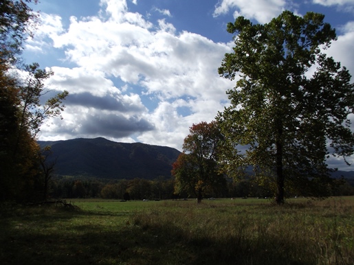
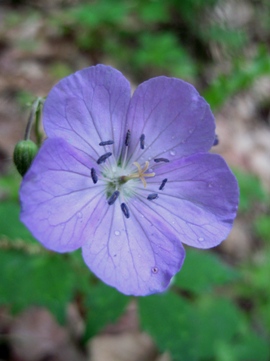
During the first leg of the hike you'll pass by one of the meadows that make Cades Cove one of the most popular destinations in the entire National Park System. During late spring these meadows are carpeted in wildflowers such as black-eyed Susans, butterfly weed, purple phacelia, jewelweed and daisies, among many other varieties.
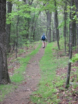
At roughly one-half mile hikers will arrive at the Crooked Arm Ridge Trail junction, which marks the beginning of the loop portion of this hike. For purposes of this description we hiked the loop in a clockwise direction, so we veered left at this junction and continued westbound along the Rich Mountain Loop Trail.
During the first segments of the hike we noticed the early blooms of mountain laurel sprinkled throughout the woods. The din of cicadas could also be heard, as the first of the 17-year brood (in 2008) was just beginning to emerge from the ground as adults. We were also greeted by a lone turkey crossing over the path roughly thirty feet in front of us.
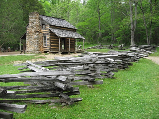
At just under 1.4 miles hikers will reach the John Oliver cabin. A veteran of the War of 1812, John Oliver, his wife Lucretia (or Luraney), and their young child, arrived in Cades Cove in 1818, and were among the first white homesteaders to settle in the area. The cabin dates from the 1820s, and is one of the oldest structures in the Great Smoky Mountains National Park.
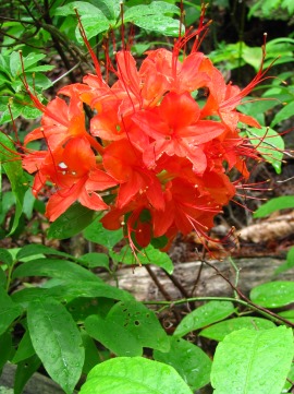
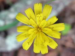
If you're simply looking for an easy hike in the Cades Cove area this would be a good place to turn around. However, if you're looking for the wildflowers that make this trail famous, you'll have to proceed further along the loop. In fact, the Rich Mountain Loop might have the most diverse amount of wildflowers we've seen in the Smokies. We saw mountain laurel, flame azalea, purple phacelia, violets, rattlesnake hawkweed, yellow ragwort, butterfly weed and many other varieties we couldn't identify.
After passing the Oliver Cabin the trail begins a long steady climb towards the junction with Indian Grave Gap Trail, roughly two miles away. Just before reaching the junction you'll pass a small dirt clearing that looks like an old camp site. This spot provides a nice birds-eye view of Cades Cove.
The Indian Grave Gap Trail junction arrives roughly 3.4 miles from the trailhead. To continue on the loop hike, turn right onto Indian Grave Gap Trail. Although you'll continue to climb along this new trail, the terrain won't be quite as steep as the previous section.
At 4.2 miles you'll reach the Rich Mountain Trail junction, which branches off to the left. Hikers should stay to the right here and continue along the Indian Grave Gap Trail.
Roughly one-third of a mile from the junction you should begin looking for a faint, unmarked trail that branches off towards the left. This short, but steep path will take you up to Cerulean Knob, the highest point on Rich Mountain. You won't have much of a view here, but you can check-out the concrete remains of the old Rich Mountain Fire Tower.
Back on the main trail, as you proceed beyond this junction, you'll begin to enjoy some decent views of Townsend and Tuckaleechee Cove on your left (looking towards the north). You'll also notice that the trail has flattened out for a relatively long stretch, before it begins heading downhill. From time to time you'll also catch a few glimpses of Cades Cove on your right. As you might expect, the views of the Cove are much better during the winter months when there aren't any leaves on the trees.
At roughly 5.9 miles from the trailhead you'll reach a three-way trail junction. The Scott Mountain Trail branches off to your left and leads to Schoolhouse Gap, while the Crooked Arm Ridge Trail branches off to the right. Hikers should turn right onto the Crooked Arm Ridge Trail to complete the loop hike. Less than a half-mile from this junction will be your last decent view into Cades Cove.
At just under 8 miles Crooked Arm Falls will appear on your left. This small 25-foot falls is roughly 50 feet off the trail.
From the waterfall, after walking a very short distance, you'll return back to the Rich Mountain Loop Trail. Hikers should turn left at this junction to return back to the Cades Cove parking lot.
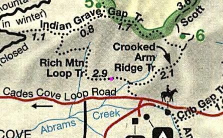
Rich Mountain Loop Map
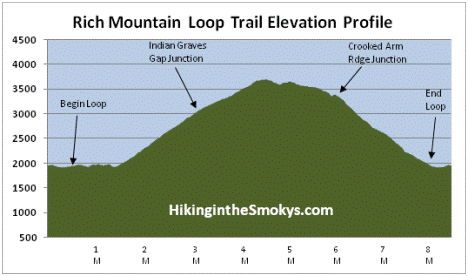
Rich Mountain Loop Elevation Profile
Directions to Trailhead:
The Rich Mountain Loop in the Great Smoky Mountains begins in Cades Cove. To reach the trailhead from the Townsend "Y" intersection, drive 7.7 miles west on Laurel Creek Road towards Cades Cove. Hikers will park in the large lot on the left, just before reaching the one-way portion of the Cades Cove Loop Road. The trailhead for the Rich Mountain Loop is located roughly 50 feet beyond the gate on the right side of the road.