Silers Bald Highlights
- Trail Features
Panoramic Views
- Trail Location
Clingmans Dome
- Roundtrip Length
9.3 Miles
- Elevation Gain (total)
2152 Feet
- Elevation Gain (per mile)
463 Feet
- Trail Difficulty
13.60
Strenuous
This strenuous hike is 9.3 miles roundtrip and includes 2152 feet of elevation gain.
Silers Bald Description
The hike to Silers Bald on the Appalachian Trail begins from the Forney Ridge Trailhead. From the parking lot, after traveling less than two-tenths of a mile, a spur trail will branch off towards the right. Hikers should turn right here to proceed towards the Appalachian Trail.
Over the next half-mile this spur trail climbs steadily along a rugged and rock-strewn pathway, before arriving at the Appalachian Trail junction. Our climb was made a little more pleasant by several song birds that serenaded us as we hiked though a thick morning fog.
Upon reaching the Appalachian Trail, hikers should turn left (towards the west) to continue towards Silers Bald.
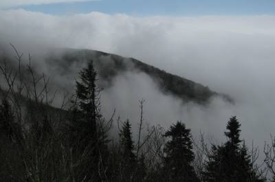
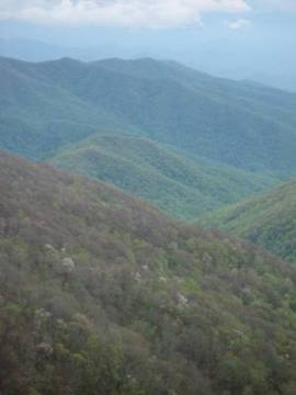
Although we couldn't see anything on the way out, there are several points along this stretch of the A.T., over the course of first half-mile or so, that offer outstanding views.
Along this same stretch we saw a fair amount of spring beauties that were just beginning to bloom during our mid-May hike. We also saw Trout-Lily, violets and white trillium as we proceeded down towards Double Spring Gap. Much of this portion of the Appalachian Trail also passes through an old-growth spruce-fir forest.
At 2.6 miles you'll arrive at the Goshen Prong Trail, which branches off towards the right. Hikers should proceed straight ahead to continue along the Appalachian Trail at this junction.
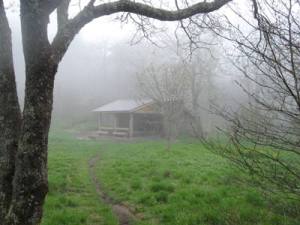
At 3.2 miles hikers will reach the Double Spring Gap Shelter. Just beyond the shelter we passed through several acres of forest floor that were literally carpeted in spring beauty. This stretch of trail, however, was a complete mess. Due to several days of rain prior to our hike, long segments of the trail, several hundred yards in length in some cases, were mired in deep mud and muck, which made for some fairly difficult hiking.
At 4.5 miles hikers will reach the Welch Ridge Trail junction. You should veer right here to continue along the Appalachian Trail towards Silers Bald. The sign at this junction states that Silers Bald is 0.4 miles away. This refers to the backcountry shelter. The summit is actually only 0.15 miles away, after trekking up a fairly steep climb.
As you might have already gathered, we experienced quite a bit of fog on the day of our hike. Unfortunately this includes our time at the summit as well, so I don't have any photos to show what you can expect to see from atop the bald.
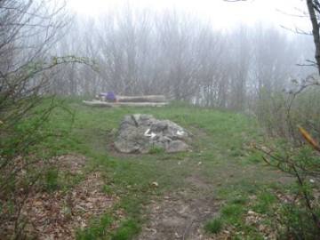
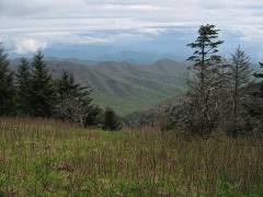
At the summit hikers will find a U.S. Geological Survey marker on top of a large rock in the middle of a very small clearing (the photo on the right shows what this area looked like in 2009). There's also a trail that runs perpendicular from the Appalachian Trail. This short side trail, maybe 50 yards in length, leads you to a vantage point that overlooks Miry Ridge.
While Silers Bald was a grassy meadow for most of the 19th and early-20th centuries, it was likely a wooded peak before the arrival of European settlers. For this reason the National Park Service no longer maintains the bald atop the mountain. Since our hike in 2009 the grassy meadow area pictured above is now mostly overgrown. However, as recently as the 1930s, a local writer and an avid hiker by the name of Laura Thornborough visited Silers Bald, and recalled it as being a giant meadow at that time.
Indeed, by the late 1800s, Silers Bald was at the far eastern end of a giant grassy pasture that stretched all the way to Gregory Bald. Silers Bald is mentioned several times in Horace Kephart's Our Southern Highlanders as the last stop before one enters a heavily-wooded wilderness. According to Kephart, beyond "Hall cabin" (a herder's shack near Big Chestnut Bald, six miles east of Thunderhead):
"...there is just one shack, at Siler's Meadow. It is down below the summit, hidden in timber, and you would never have seen it. Even if you had, you would have found it as bare as a last year's mouse nest, for nobody ever goes there except for a few bear-hunters. From there onward for forty miles is an uninhabited wilderness so rough that you could not make seven miles a day in it to save your life..."
Silers Bald is named after Jesse Siler, a prominent North Carolinian who grazed sheep and cattle atop the mountain in the 1800s. To the south, in the Nantahala Mountains, there's another Silers Bald named after Jesse's brother, William.
If you continue hiking a little more than a tenth-of-a-mile beyond the summit you'll run into a larger meadow, maybe a half-acre in size. It's possible that this meadow offers views into North Carolina, but I couldn't tell for sure.
On our return back to the trailhead that day we were fortunate to have a brief window where the dense fog broke for about ten minutes, giving me enough time to snap a few photos.
Before reaching the parking area on your return trip you'll have two options: you can either take the same route, or you can bypass the A.T. spur trail and continue eastward along the Appalachian Trail to reach Clingmans Dome. This would be a good option if you've never been to the highest point in the state of Tennessee.
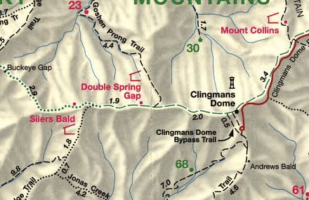
Silers Bald Map
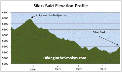
Silers Bald Elevation Profile
Directions to Trailhead:
From the Sugarlands Visitor Center near Gatlinburg, drive 13.2 miles south along Newfound Gap Road to Clingmans Dome Road. Turn right onto Clingmans Dome Road and drive another 7 miles - all the way to the end of the road. Due to its popularity, the parking lot for the Clingmans Dome area is very large. To reach Silers Bald you'll begin your hike from the Forney Ridge Trailhead, located at the far end of the parking lot.
From Cherokee, drive north on Newfound Gap Road for 20 miles to reach Clingmans Dome Road.