Smokemont Loop Highlights
- Trail Features
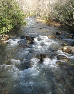
Stream, Wildflowers
- Trail Location
Smokemont Campground
- Roundtrip Length
6.5 Miles
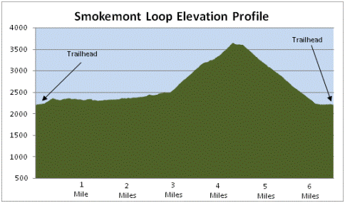
- Elevation Gain (total)
1441 Feet
- Elevation Gain (per mile)
443 Feet
- Trail Difficulty
9.38
Moderately Difficult
This moderately difficult hike is 6.5 miles roundtrip and includes 1441 feet of elevation gain.
Smokemont Loop Description
Maybe it was just me, but I found a lot of issues and problems with the signage in this area, which is very uncharacteristic of the Great Smoky Mountains. First of all, there's no sign at all for the Smokemont Loop Trailhead, which begins near the southwest corner of the campground. We knew there was access to the Bradley Fork Trail at the northern end of the campground, but that portion of the campground was closed for the winter. So, having never been here before, we weren't exactly sure where we needed to pick-up the trailhead.
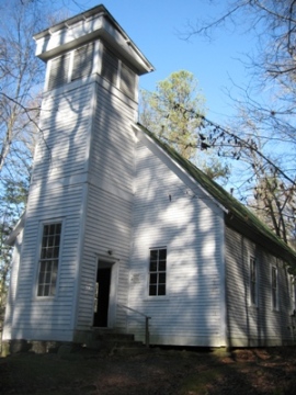
We decided to begin this hike from the trailhead located directly across the bridge that spans the Oconaluftee River as you turn onto the campground entrance road. This is also located near the Luftee Baptist Church - or is it the Smokemont Baptist Church? For some reason the national park has two signs in this vicinity, seemingly indicating two names for the same church.
This particular location is now marked on the current official trail map as the trailhead for this hike. Prior maps showed the trail starting from the far end of the campground. If you started your hike from the old location at the north end of the campground you would cut-off less than four-tenths-of-a-mile from the total hiking distance listed for this hike description.
At the new trailhead, look for the sign indicating access to the Bradley Fork Trail.
The first two miles of this hike follows along with the Benton MacKaye Trail, a footpath stretching nearly 300 miles through the Southern Appalachian Mountains (including 96 miles in the Great Smoky Mountains). The trail was designed in the tradition of the Appalachian Trail, which was the brainchild of Benton MacKaye, a forester and co-founder of The Wilderness Society.
During the first mile or so you'll pass a series of trail signs. Continue hiking in a northerly direction while following the Benton MacKaye Trail. At just over a mile you'll finally reach the official Bradley Fork Trail.
At roughly 2 miles hikers will reach the Chasteen Creek Trail junction. From here the Benton MacKaye Trail follows Chasteen Creek, before ultimately ending its long journey at Davenport Gap. To continue on the Smokemont Loop hike, stay to the left to continue on the Bradley Fork Trail, which is a nice wide path throughout this section.
The Bradley Fork Trail is also known for its spectacular wildflower displays in the spring. During the early spring season, hepaticas, violets, and foam flower are found along the path. As the season progresses, umbrella leaf and Fraser's sedge begin to bloom along the higher elevations of the trail. You can also find wood and rue anemone, Vasey's trillium, beaked violets and crested dwarf iris during the April and May time period. From April thru July, look for wild strawberry, Robin's plantain and Canadian violets.
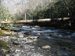
At just over 2.5 miles from the trailhead hikers will arrive at the Smokemont Loop Trail junction. Turn left here and walk down the hill. At the bottom you'll cross over the Bradley Fork on one of the longest footbridges in the park. Soon after crossing the log bridge the trail begins a steady climb of more than 1100 feet over the next 1.4 miles as it traverses along the northeastern slopes of Richland Mountain.
As you approach the top of the climb hikers will enjoy sporadic and partial views of Newfound Gap and the North Carolina side of the Smokies.
At nearly 6.2 miles hikers will arrive at the Smokemont Campground. To complete the loop you'll have to walk another three-tenths of a mile down the campground entrance road to reach the parking area.
Just before reaching the Smokemont Campground, and before crossing the old auto bridge, which was built in 1921, the trail passes the small, partially overgrown Bradley cemetery, which will be on your right.
As one of the base camps for the Champion Fibre Company, Smokemont was once a thriving lumber community with homes, businesses and a school. It also housed a logging mill, commissary, a club house, and even a hotel. In the early 1920s the sawmill at Smokemont produced up to 45,000 feet of lumber and pulp wood per day.
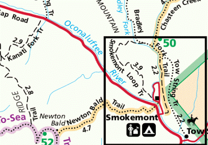
Smokemont Loop Map
Smokemont Loop Elevation Profile
Directions to Trailhead:
From the Oconaluftee Visitor Center near Cherokee, drive 3.5 miles north along Newfound Gap Road to reach the turn-off for the Smokemont Campground. The parking area for this hike is located directly across the bridge as you turn into the campground. The trailhead provides access to the Bradley Fork Trail, which forms the eastern segment of the Smokemont Loop hike.
From the Sugarlands Visitor Center near Gatlinburg, drive 25.6 miles south along Newfound Gap Road to reach the Smokemont Campground.