Spence Field (via Anthony Creek) Highlights
- Trail Features
Panoramic Views, Mountain Laurel
- Trail Location
Cades Cove Picnic Area
- Roundtrip Length
10.3 Miles
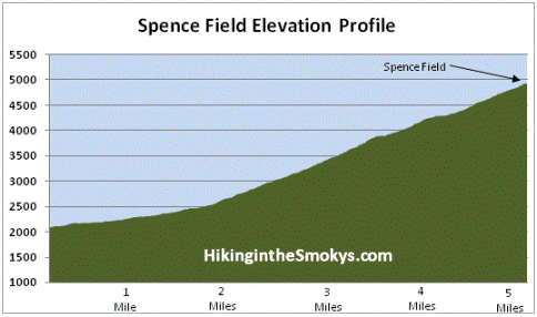
- Elevation Gain (total)
2842 Feet
- Elevation Gain (per mile)
552 Feet
- Trail Difficulty
15.98
Strenuous
This strenuous hike is 10.3 miles roundtrip and includes 2842 feet of elevation gain.
Spence Field (via Anthony Creek) Description
The Anthony Creek Trail starts off by following Abrams Creek out of Cades Cove. At just three-tenths of a mile from the trailhead hikers will pass the Crib Gap Trail junction, and then shortly thereafter, the Anthony Creek Horse Camp. You may have already noticed some of the "clues" left on the ground indicating that this trail also functions as a horse path.
We last hiked this trail in mid-June when the rhododendron were just beginning to bloom along the lower sections of the trail.
At just over 1.7 miles the Russell Field Trail will branch off to the right. Hikers should continue by proceeding straight ahead at this junction. Further up the path, roughly 3.5 miles from the picnic area, the Anthony Creek Trail dead-ends into the Bote Mountain Trail. Hikers should turn right at this junction to continue on towards Spence Field.
As you climb the Bote Mountain Trail you'll begin walking through a long stretch of trail where rhododendron has formed a tunnel over the footpath. You'll also notice that the trail has sunk several feet below the ground on either side of the trail. My guess is that this is the result of a combination of erosion, and the trampling of the sheep and cattle that were driven to and from Spence Field prior to the establishment of the national park.
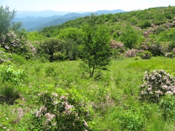
At just over 5.1 miles hikers will reach the Appalachian Trail at Spence Field. If you turn right at this junction you'll pass through a series of small grassy meadows. These are pleasant meadows, but nothing compared to what you'll find on the other side of the junction.
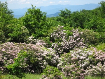
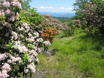
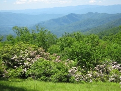
If visibility is good during your visit atop Spence Field you'll have some absolutely outstanding views of the North Carolina side of the Smokies. And if you're there in June you'll witness one of the most spectacular displays of mountain laurel found just about anywhere. The hillsides and meadows will literally be covered in the soft pink and white flowers from this heath family shrub.
Hikers will only have to walk about 100 yards or so beyond the junction to find a great spot to enjoy a picnic lunch, or to simply soak in the grand scenery.
Spence Field is named after James Spence, who built a cabin in this area in 1830. The History of the Grassy Balds in Great Smoky Mountains National Park, an online book that can be found on the park website, states that neither Russell or Spence Field are natural grassy balds, but were actually cleared by settlers for the purposes of grazing sheep and cattle during the summer months.
If you still have the energy at this point you could continue walking eastward along the Appalachian Trail for another 1.2 miles to reach Rocky Top. Although you'll have to climb another 550 feet, the views from this vantage point might be some of the best in the park.
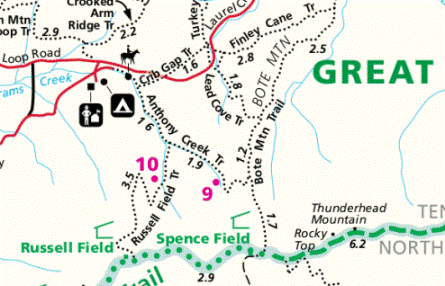
Spence Field (via Anthony Creek) Map
Spence Field (via Anthony Creek) Elevation Profile
Directions to Trailhead:
This hike to Spence Field begins from the Anthony Creek Trailhead, located in the Cades Cove picnic area. To reach the trailhead from the Townsend "Y" intersection, drive 7.5 miles west on Laurel Creek Road to the turn-off for the Cades Cove Campground. Turn left towards the campground, and then almost immediately you'll make another left turn towards the picnic area. The Anthony Creek Trailhead is located at the far end of the picnic area.