Spence Field (via Lead Cove Trail) Highlights
- Trail Features
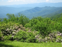
Panoramic Views, Mountain Laurel
- Trail Location
Between Townsend and Cades Cove
- Roundtrip Length
9.4 Miles
- Elevation Gain (total)
3100 Feet
- Elevation Gain (per mile)
660 Feet
- Trail Difficulty
15.60
Strenuous
This strenuous hike is 9.4 miles roundtrip and includes 3100 feet of elevation gain.
Spence Field (via Lead Cove Trail) Description
The Lead Cove Trail offers the shortest hike to Spence Field. The trail's name is supposedly derived from the lead ore that was extracted in this vicinity during the 1800s.
Towards the beginning of the hike you'll pass an old homestead site on your left. Shortly thereafter the trail begins following along the Sugar Cove Prong. At roughly three-quarters of a mile the trail branches away from the creek and begins climbing steeply towards the Bote Mountain Trail. At 1.8 miles the Lead Cove Trail finally dead-ends into the Bote Mountain Trail. At this point you will have already climbed nearly 1300 feet. To continue on towards Spence Field hikers should turn right at this junction.
As you ascend the Bote Mountain Trail you'll be hiking through a fairly open pine-oak forest, with intermittent views of Defeat Ridge towards the left.
At roughly 3 miles the Anthony Creek Trail will branch off towards the right. Hikers should continue towards their destination by proceeding straight ahead here.
As you continue climbing you'll begin walking through a long stretch of trail where rhododendron has formed a tunnel over the footpath. You'll also notice that the trail has sunk several feet below the ground on either side of the trail. My guess is that this is the result of a combination of erosion, and the trampling of the sheep and cattle that were driven to and from Spence Field prior to the establishment of the national park.
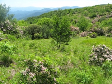
At roughly 4.7 miles hikers will reach the Appalachian Trail at Spence Field. If you turn right at this junction you'll pass through a series of small grassy meadows. These are pleasant meadows, but nothing compared to what you'll find on the other side of the junction.
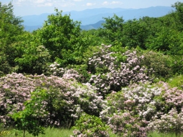
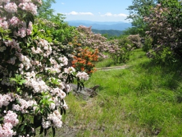
If visibility is good during your visit atop Spence Field you'll have some absolutely outstanding views of the North Carolina side of the Smokies. And if you're there in June you'll witness one of the most spectacular displays of mountain laurel found just about anywhere. The hillsides and meadows will literally be covered in the soft pink and white flowers from this heath family shrub.
Hikers will only have to walk about 100 yards or so beyond the junction to find a great spot to enjoy a picnic lunch, or to simply soak in the grand scenery.
Spence Field is named after James Spence, who built a cabin in this area in 1830. The History of the Grassy Balds in Great Smoky Mountains National Park, an online book that can be found on the park website, states that neither Russell or Spence Field are natural grassy balds, but were actually cleared by settlers for the purposes of grazing sheep and cattle during the summer months.
If you still have the energy at this point you could continue walking eastward along the Appalachian Trail for another 1.2 miles to reach Rocky Top. Although you'll have to climb another 550 feet, the views from this vantage point might be some of the best in the park.
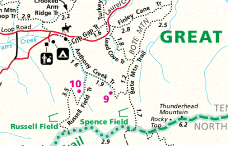
Spence Field (via Lead Cove Trail) Map
Directions to Trailhead:
This hike to Spence Field begins from the Lead Cove Trailhead near Cades Cove. To reach the trailhead from the Townsend "Y" intersection, drive 5.6 miles west on Laurel Creek Road towards Cades Cove. The parking area for the Lead Cove Trail will be on your left. There's parking on both sides of the road, however, the Lead Cove Trail is on the left side, and heads south from the road.