Spruce-Fir Trail Highlights
- Trail Features
Spruce-fir Forest
- Trail Location
Clingmans Dome Road
- Roundtrip Length
0.35 Miles
- Elevation Gain (total)
25 Feet
- Elevation Gain (per mile)
143 Feet
- Trail Difficulty
0.40
Easy
This easy hike is 0.35 miles roundtrip and includes 25 feet of elevation gain.

Spruce-Fir Trail Description
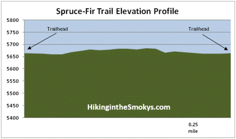
Although the Spruce-Fir Trail isn't on the official park map, it is maintained by the National Park Service. Hikers may also want to note that there's a large park sign at the trailhead that mentions a section of trail that climbs a 12% grade. I'm not sure what they're talking about here. This is a virtually flat trail, with an elevation change of only 25 feet along the entire course of the 0.35-mile route.
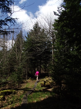
The Spruce-Fir Nature Trail is a short easy hike through a beautiful spruce-fir forest, as the name would imply. Spruce-fir forests are only found at the park's highest elevations. While red spruce and Fraser firs are the main components, yellow birch, mountain-ash, hobblebush and blackberries can also be found here. The climate of the spruce-fir forests in the Great Smoky Mountains are very similar to that of what is found in the boreal forests of Maine and Quebec, Canada.
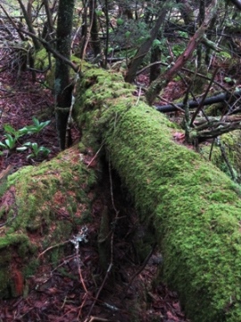
Much of the trail follows along wooden boardwalks as you pass through this lush green forest. Unfortunately the forest is under attack from the balsam woolly adelgid, an insect from Europe that's killing fir trees throughout the Smokies. You'll likely notice a lot of dead trees lying on the ground as you walk along the path. The adelgids inject trees with toxins that block the path of nutrients, which effectively starves them to death. Since the early 1960s more than 90% of the Fraser firs in Great Smoky Mountains National Park have already been destroyed. Fortunately, a second generation of Fraser firs are already growing in areas that were decimated decades ago. There's also evidence that there may be some genetic resistance among trees that have managed to survive so far.
As you wind your way around the loop you'll also notice several large quartz rocks on the ground, which, at first glance, look like blocks of ice and snow leftover from the previous winter. These are actually leftovers from the Precambrian era some 500 million years ago.
Depending on your timing, hikers may find a wide variety of wildflowers in this forest, including wake robin, spring-beauty and trillium, among several other varieties. Look closely and you could spot a variety of wildlife as well. Red-cheeked salamanders, pygmy salamanders, red squirrels, winter wrens, juncos and nuthatches all live at the highest elevations in the park for at least a part of the year.
The first time we hiked this trail a cold wind howled above us, however, the thick evergreen trees provided a sufficient wind break that kept us relatively warm. The park is now warning visitors not to hike this trail during high wind or heavy rain events, as there is the threat of falling trees in this area.
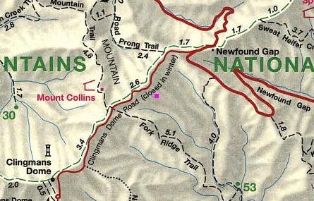
Spruce-Fir Trail Map
Spruce-Fir Trail Elevation Profile
Directions to Trailhead:
From the Sugarlands Visitor Center near Gatlinburg, drive 13.2 miles south along Newfound Gap Road to Clingmans Dome Road. Turn right onto Clingmans Dome Road and drive another 2.7 miles to reach the parking area for the Spruce-Fir Nature Trail on the left side of the road. Just before reaching the parking area you'll see a small sign on the right side of the road for "nature trail", which will indicate the approach of the trailhead.
From Cherokee, drive 20 miles north on Newfound Gap Road to reach Clingmans Dome Road.