
Mt. Sterling (via Baxter Creek) Highlights
- Trail Features
Panoramic Views, Wildflowers
- Trail Location
Big Creek
- Roundtrip Length
12.2 Miles
- Elevation Gain (total)
4200 Feet
- Elevation Gain (per mile)
689 Feet
- Trail Difficulty
20.60
Strenuous
This strenuous hike is 12.2 miles roundtrip and includes 4200 feet of elevation gain.

Mt. Sterling (via Baxter Creek) Description
There are several trails that will lead you to the summit of Mt. Sterling; however, the toughest route to the historic fire tower is the Baxter Creek Trail, which begins from the Big Creek area. In fact, the Baxter Creek Trail to the top of Mt. Sterling is one of the toughest day hikes in the Great Smoky Mountains. Although even and well-graded, the trail climbs roughly 4200 feet in just 6.2 miles.
From the trailhead hikers will cross over a steel footbridge that spans Big Creek. From here the path more or less follows Big Creek for the next half-mile or so, before it begins climbing the northern slopes of Mt. Sterling.
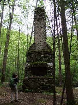
At roughly one-third of a mile from the trailhead hikers will reach an unmarked side trail that forks off to the right. From the main trail you'll see what looks to be the remnants of an old rock wall. If you continue walking along this side trail for roughly one-tenth of a mile past the rock wall, you'll reach a massive stone chimney near the banks of the creek. Standing roughly 30 or 35 feet high, this chimney is all that remains from an old lodge that was once owned by the Crestmont Lumber Company.
After crossing Baxter Creek at roughly seven-tenths of a mile, the trail begins passing through sections of lush old-growth forest. According to the Eastern Native Trees Society some of the largest trees in the park are located in this area, including the largest tulip tree in the park, which stands more than 177 feet in height. In addition to several other champion tulip trees, the largest Northern red oak, Carolina silverbell and Cucumbertree are also located in this area. As hikers climb higher the deciduous forest eventually gives way to a balsam, spruce and fir forest at the higher elevations.
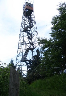
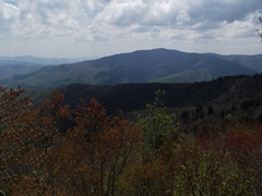
Although a very difficult hike, your efforts will be well rewarded upon reaching the 5842-foot summit. The views atop the 60-foot fire tower are simply amazing. On a clear day you'll be able to see Balsam Mountain and Luftee Knob towards the west, Mount Guyot to the northwest, Max Patch to the east, and the Cataloochee Valley towards the south. If you have a very good eye you may even be able to spot the Mount Cammerer fire tower, which lies due NNW from the mountain.
It was here atop Mount Sterling in 1963 that the balsam woolly adelgid infestation was first noticed in the Smokies. This tiny insect is now responsible for killing most of the park's Fraser firs.
The 60-foot fire tower at the summit was built by the Civilian Conservation Corps in 1935. In the park's early days a lookout spent many hours in the tower, keeping a close eye on the heavily forested terrain of the surrounding mountains. From February 15th to May 15th, and then again from October 15th to December 15th, the tower was manned by lookouts who lived on the premises on two-week tours. When he wasn't at his station the watchman stayed in a small cabin that once stood just north of the tower.
Today the Park Service uses the tower as a radio repeater. The trap door is still open, and if you don't mind a shaky old structure, the views are quite breathtaking.
According to Peter Barr, author of "Hiking North Carolina's Lookout Towers," the Mt. Sterling lookout has the highest elevation of any true fire tower left standing in the eastern U.S. In addition to a wealth of historical background on fire towers, his book also serves as a hiking guide to many of the towers in the region.
The Mount Sterling area is one of the more historic places in the Great Smoky Mountains. According to the early settlers in the area, the mountain was given its name after a two-foot wide streak of lead was found in the bed of the Pigeon River, near the northeastern base of the mountain. Unfortunately those residents mistakenly thought they had found silver.
One of the most famous stories associated with the area occurred during the Civil War. Towards the end of the war the remote valleys around the base of Mt. Sterling became popular hideouts for deserters from both sides of the war. Both Northern and Southern troop detachments would make frequent raids into the area to find and capture the fugitives.
One local legend recounts an incident in which Captain Albert Teague of the Confederate Army captured three deserters: George Grooms, his brother Henry, and Mitchell Caldwell, a man described as being a simpleton. The three captives were forced to march on foot from Big Creek, over Mt. Sterling Gap, and then down to the Cataloochee Turnpike near Indian Grave Branch. Known as a talented fiddle player, Henry Grooms was purportedly ordered to carry his fiddle during the long march. Just before his execution his captors demanded that he play one last tune. He fittingly chose to play "Bonaparte's Retreat," a haunting melody that to this day is still known as "The Grooms Tune" in many parts of the region.
Before their execution Grooms asked if he could pray for a moment. His brother Henry is said to have died cursing the troopers, while Caldwell simply grinned. This so unnerved the captors that they were forced to cover his face with his hat before mustering the strength to shoot him. Teague's unit simply left the three bodies on the side of the road.
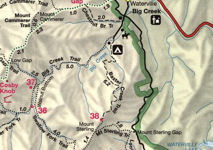
Mt. Sterling (via Baxter Creek) Map
Directions to Trailhead:
From I-40 near the Tennessee-North Carolina border, take the Waterville Road Exit (#451). Turn left after crossing the Pigeon River and proceed 2.1 miles to a 4-way intersection. Continue straight ahead onto the narrow gravel road and drive past the ranger station to a large parking area at the end of the road. The Baxter Creek Trailhead is located on the far side of the Big Creek picnic area, roughly 3 miles from the highway.