Sugarland Mountain Trail Highlights
- Trail Features
Quiet Forest Hike, Solitude
- Trail Location
Little River Road
- Roundtrip Length
6.0 Miles
- Elevation Gain (total)
1500 Feet
- Elevation Gain (per mile)
500 Feet
- Trail Difficulty
9.00
Moderately Difficult
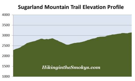
This moderately difficult hike is 6.0 miles roundtrip and includes 1500 feet of elevation gain.
Sugarland Mountain Trail Description
The Sugarland Mountain Trailhead is located across the street from the Laurel Falls Trailhead at Fighting Creek Gap. With Laurel Falls being one of the most popular destinations in Great Smoky Mountains National Park, parking is usually a major problem here. If you wish to avoid a full parking lot your best bet is to begin your hike early in the morning, during the early evening hours, on a weekday, or during the off-season.
Legend has it that Fighting Creek Gap received its name many years ago after two motorists fought for the last parking spot on a warm summer afternoon. But who knows if that's really true....
Although there might be 50 or 60 cars jammed into the parking area, it's almost guaranteed that 99% of those visitors are headed up to Laurel Falls. Despite appearances, the Sugarland Mountain Trail offers solitude for those seeking it in the heart of the Smokies.
Sugarland Mountain is a massive ridge that stretches nearly 10 miles, and runs perpendicular to the main crest of the Smokies. The mountain intersects the crest at the summit of 6188-foot Mount Collins.
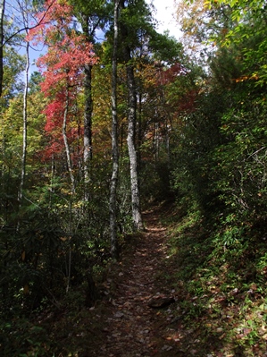
The trail starts off with an extremely steep climb, gaining over 550 lung-busting feet in just seven-tenths of a mile. This probably explains why everyone else is headed up to Laurel Falls! Along this first stretch of trail are some fairly steep drop-offs.
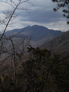
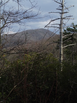
At roughly four-tenths of a mile from the trailhead you'll reach an opening in the canopy that provides a pretty good view of the Gatlinburg area during the winter months. From this perch you'll be able to see a couple of the taller buildings in the area - when there aren't any leaves on the trees.
A little further up the footpath you'll reach a spot where a massive tree ripped a fairly large section of trail away several years ago. The national park had to do some repair work to make the trail passable once again.
At seven-tenths of a mile the trail begins to level out, and then shortly thereafter, begins heading downhill. As you proceed downward you'll enjoy some pretty good views of Mt. LeConte and Brushy Mountain towards the east. From this point forward the trail quietly meanders along as it makes its way towards Huskey Gap, while offering hikers all the solitude they could possibly want.
As you continue along you'll find a spot that offers some pretty good views of Mt. LeConte and Sugarland Mountain, albeit through the trees. Although not a clear view, it might be one of the best views of LeConte in terms of seeing its massive size.
At 3 miles hikers will arrive at Huskey Gap. In the late 19th century the residents of the small communities of Little River (now known as Elkmont) and the Sugarlands built a log schoolhouse at Huskey Gap. They also constructed a road which would eventually become the Huskey Gap Trail.
If you have two cars in your group you'll have the option of creating a one-way hike to Newfound Gap Road, via the Huskey Gap Trail, which would make for a total hike of 5.2 miles. You could also take the Huskey Gap Trail in the opposite direction, which would lead you down to the Little River Trail and eventually back to Elkmont, making this an eight-mile, one-way hike.
Backpackers should note that Backcountry Campsite 21 has been moved. In 2009 the site was relocated from the Sugarland Mountain Trail, just south of Huskey Gap, to its current location near the junction of the Huskey Gap and Little River trails.
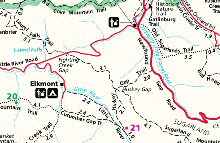
Sugarland Mountain Trail Map
Sugarland Mountain Trail Elevation Profile
Directions to Trailhead:
From the Sugarlands Visitor Center near Gatlinburg, drive 3.8 miles west along Little River Road to the top of Fighting Creek Gap. The main parking area for the Sugarland Mountain Trail will be on your left, with additional parking across the street.
From the Townsend "Y" intersection near Cades Cove, the Sugarland Mountain Trailhead is located 13.7 miles away.