Sugarland Mountain Trail (upper) Highlights
- Trail Features
Views, Solitude, Old Growth Forest
- Trail Location
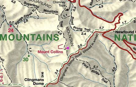
Clingmans Dome Road
- Roundtrip Length
7.0 Miles
- Elevation Gain (total)
1090 Feet
- Elevation Gain (per mile)
311 Feet
- Trail Difficulty
9.18
Moderately Difficult
This moderately difficult hike is 7.0 miles roundtrip and includes 1090 feet of elevation gain.
Sugarland Mountain Trail (upper) Description
On October 25, 2018 Great Smoky Mountains National Park announced the reopening of the Sugarland Mountain Trail after being closed for almost two years due to the November 2016 wildfire. On November 23, 2016 two juveniles started a wildfire near the summit of Chimney Tops. By November 28th the fire grew to 500 acres. After several months of exceptional drought conditions, and winds gusts reaching more than 80 mph that afternoon, the fire literally exploded. Over the next several hours it burned almost 18,000 acres, including 11,410 acres within Great Smoky Mountains National Park. From Chimney Tops the fire raced north, passing around the edges of downtown Gatlinburg and reaching the outskirts of Pigeon Forge. Before it was brought under control the fire killed 14 people, injured more than 176 people, and damaged or destroyed at least 2460 structures at a cost of more than $500 million.
As mentioned above, hikers should take the short access trail across the road to reach the Appalachian Trail. Upon reaching the A.T., turn left. Less than one-third of a mile later you'll arrive at the Sugarland Mountain Trail junction. Hikers should turn right here. In a short distance, roughly six-tenths of a mile from the road, hikers will pass the Mt. Collins backcountry shelter. Both the shelter and the nearby mountain are named after Robert Collins, an Oconaluftee resident who guided Arnold Guyot across the crest of the Smokies in the late 1850s.
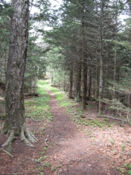
During the first mile or so the path travels through a lush-green, spruce-fir forest, while traversing over a fairly rocky trail bed. During our early May hike we saw a fair amount of spring beauty, trout-lily and Wake Robin along this stretch of the trail.
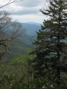
At just over a mile the trail begins to climb again. You'll start to notice the ridge narrowing as you continue to gain altitude. From this point forward intermittent breaks in the foliage will provide you with partial views of the surrounding mountains on either side of the trail.
Roughly 2.3 miles from Clingmans Dome Road the trail passes just below the summit of 5494-foot Sugarland Mountain, which will be on your left, towards the west.
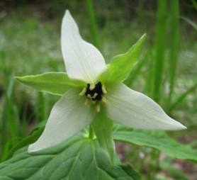
Just beyond this point, as the trail begins to descend again, we ran into a thick carpet of spring beauties. We also saw several sweet white trilliums in this area as well.
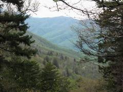
At roughly 3.5 miles there will be a slight rise in the trail, at which point the trail makes a sharp left-hand turn. It's at this point that Gatlinburg comes into view. You'll also hear the faint din of traffic on Newfound Gap Road below you. Of course the trail continues all the way down to Fighting Creek Gap on Little River Road, but this small vantage point marks the end of this particular hike.
Before turning around, stand facing Gatlinburg for a moment. If Gatlinburg is at the 12:00 position, turn your head towards the 2:00 position. If you're taller than the average person, or if you're hiking during the winter or early spring time period, look slightly down and you might be able to see Chimney Tops across the valley. You may even be able to see or hear hikers near the summit of this popular destination.
Although there isn't a big payoff in terms of panoramic views, the reward of this hike is in the serenity of the forest and the solitude you're likely to find. Although we hiked this trail on a Sunday afternoon, we didn't see a single soul the entire time we were out on the trail.
Sugarland Mountain Trail (upper) Map
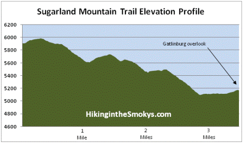
Sugarland Mountain Trail (upper) Elevation Profile
Directions to Trailhead:
From the Sugarlands Visitor Center near Gatlinburg, drive 13.2 miles south along Newfound Gap Road to Clingmans Dome Road. Turn right onto Clingmans Dome Road and drive another 3.6 miles to the parking area for the Fork Ridge Trail on the left side of the road. Across the street, on the right side of the road, will be a sign that reads "Appalachian Trail". This is a short access trail that will take you to the Appalachian Trail, which in a short distance will lead you to the Sugarland Mountain Trail.
From Cherokee, drive 20 miles north to reach Clingmans Dome Road.