
Rocky Top / Thunderhead Mountain Highlights
- Trail Features
Panoramic Views, Mountain Laurel
- Trail Location
Cades Cove Picnic Area
- Roundtrip Length
13.9 Miles
- Elevation Gain (total)
3665 Feet
- Elevation Gain (per mile)
527 Feet
- Trail Difficulty
21.23
Strenuous
This strenuous hike is 13.9 miles roundtrip and includes 3665 feet of elevation gain.
Rocky Top / Thunderhead Mountain Description
The Anthony Creek Trail begins by following Abrams Creek. We last hiked this trail in mid-June when the rhododendron were just beginning to bloom along the lower sections of the trail. After walking just three-tenths of a mile you'll pass the Crib Gap Trail junction, and then shortly thereafter, the Anthony Creek Horse Camp. You may have already noticed some of the "clues" left on the ground indicating that this trail also functions as a horse path.
At just over 1.7 miles the Russell Field Trail will branch off to the right. Hikers should continue by proceeding straight ahead at this junction. Further up the path, roughly 3.5 miles from the picnic area, the Anthony Creek Trail dead-ends into the Bote Mountain Trail. Hikers should turn right at this junction to continue on towards Rocky Top.
As you climb the Bote Mountain Trail you'll begin hiking through a long stretch of trail where rhododendron has formed a tunnel over the footpath. You'll also notice that the trail has sunk several feet below the ground on either side of the trail. My guess is that this is the result of a combination of erosion, and the trampling of the sheep and cattle that were driven to and from Spence Field prior to the establishment of the national park.
At just over 5.1 miles hikers will reach the Appalachian Trail at Spence Field, where you'll turn left to continue towards Rocky Top. If you were to turn right at this junction you would pass through a series of small grassy meadows. All of these are pleasant meadows, but nothing compared to what you'll find on the opposite side of the junction.
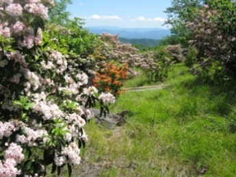
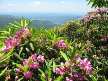
After turning left onto the Appalachian Trail you'll have some absolutely stunning views of the North Carolina side of the Smokies. And if you're there in June you'll witness one of the most spectacular displays of mountain laurel found just about anywhere. The hillsides and meadows will literally be covered in the soft pink and white flowers from this heath family shrub.
Hikers will only have to walk about 100 yards or so beyond the junction to find a great spot to enjoy a picnic lunch, or to simply soak in the grand scenery.
Spence Field is named after James Spence, who built a cabin in this area in 1830. The History of the Grassy Balds in Great Smoky Mountains National Park, an online book that can be found on the park website, states that neither Russell or Spence Field are natural grassy balds, but were actually cleared by settlers for the purposes of grazing sheep and cattle.
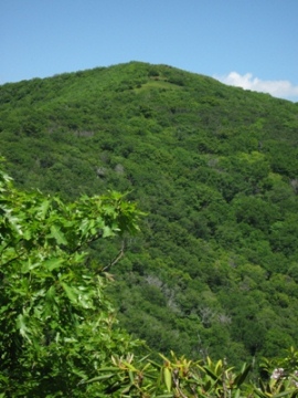
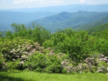
To reach Rocky Top and Thunderhead Mountain, you should continue hiking eastbound along the Appalachian Trail. Thunderhead Mountain actually consists of three summits, all of which are visible from the eastern end of Spence Field (the photo on the left shows the view you'll have of the mountain from Spence Field - the knob towards the far left is the highest point on the mountain). The first summit (or subpeak) is known as Rocky Top. According to an article published in the Saturday Evening Post, this is the same Rocky Top that inspired Felice and Boudleaux Bryant to write the famous lyrics that are now the fight song for the University of Tennessee, as well as one of the official state songs for the State of Tennessee.
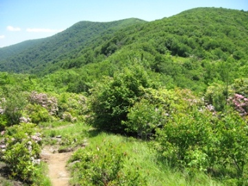
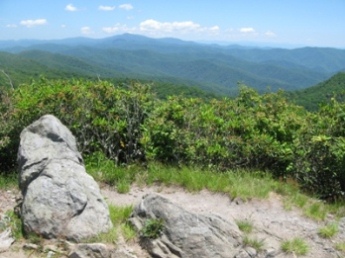
Rocky Top is roughly 1.2 miles from the Bote Mountain / Appalachian Trail junction, and requires a fairly steep climb of more than 550 feet to reach the small bald area on the western flank of the mountain (the photo on the right shows the view you'll have of Rocky Top right before you make your final ascent). The effort is well worth it though. The views are outstanding; maybe even some of the best in Great Smoky Mountains National Park (see photos below).
The day before one of our hikes a few years ago, a major front passed through the Smokies and blew most of the haze out of the area. From the summit of Rocky Top we could see Fontana Lake, Cades Cove, Townsend and Maryville, and possibly all the way up to Knoxville.
Hikers can choose to end their hike at Rocky Top, which in my opinion offers the best views among the three summits, making it one of the best hikes in the Smokies. However, if you wish proceed towards the highest point you should continue hiking eastbound on the Appalachian Trail. Along the way you'll find a couple of spots that provide outstanding views of Cades Cove.
Just a third-of-a-mile beyond Rocky Top is the middle peak on Thunderhead Mountain. Some people call this second peak "Rocky Top Two", which is really just a rocky knob. This spot also provides some pretty good views of the surrounding mountains.
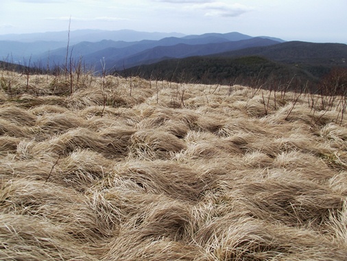
The highest point on Thunderhead Mountain is reached by walking another three-tenths of a mile beyond Rocky Top Two. Here you'll find a small sign marking the 5527-foot summit. At some point someone was kind enough to stack a few rocks at this rather unremarkable highpoint. Without this small platform you wouldn't be able to see anything but the tall shrubs that grow along either side of the trail.
Rocky Top / Thunderhead Mountain Map
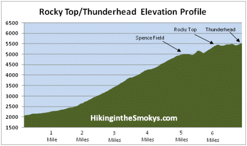
Rocky Top / Thunderhead Mountain Elevation Profile
Directions to Trailhead:
The hike to Rocky Top on Thunderhead Mountain in the Great Smoky Mountains begins from the Anthony Creek Trailhead, located in the Cades Cove picnic area. To reach the trailhead from the Townsend "Y" intersection, drive 7.5 miles west on Laurel Creek Road to the turn-off for the Cades Cove Campground. You should turn left towards the campground, and then almost immediately you'll make another left turn towards the picnic area. The Anthony Creek Trailhead is located at the far end of the picnic area.