Bicycling in the Great Smoky Mountains
Bicycles are allowed on most roads within Great Smoky Mountains National Park. However, due to heavy traffic, steep terrain, and narrow roads with limited pull-offs, many of the roads in the park simply aren't conducive for safe and enjoyable cycling. For all practical purposes, only experienced riders, using extreme caution, should attempt to ride most of the main roads in the Smokies.
 Additionally, there are no mountain biking trails in the Smokies. However, bicycles are allowed on the Gatlinburg Trail, the Oconaluftee River Trail and the lower Deep Creek Trail. These trails have been set aside for people wishing to simply take a stroll through the park on a bike. Bicycles are prohibited on all other park trails.
Below is a list of suggested road and mountain bike routes in the Great Smoky Mountains, as well as in the immediate areas surrounding the park.
Road Bike Routes
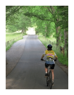
Cyclists should always obey all traffic regulations while biking in the Smoky Mountains. Safety is always a major concern where bicycles and automobiles share the road, especially when riding in mountainous areas. State laws for both Tennessee and North Carolina require that children age 16 and under wear a helmet. It's also strongly recommend that all cyclists wear helmets, use rear view mirrors, and ride properly fitted, well-maintained bikes.
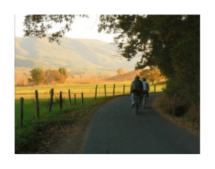
 Cades Cove Loop Road: This 11-mile one way road is a very popular option for many cyclists. It provides riders with excellent opportunities for viewing wildlife and touring 19th century homesteads. During the summer and fall, bicycles can be rented from the Cades Cove Campground Store (you can also call 865-448-9034 for more information). Beginning the second week in May, the Cades Cove Loop Road is closed to motor vehicle traffic on Wednesday and Saturday mornings until 10:00 a.m. so that cyclists and pedestrians can enjoy the cove. This closure continues through the second-to-last Saturday in September.
Townsend Bicycle Path: This paved trail, approximately 3 miles in length, is located in Townsend, Tennessee, also known as the "Peaceful side of the Smokies." It features a paved trail with a few short, easy hills, and is great for cyclists of all levels including older children. It runs parallel to Hwy. US 321 in Townsend, with a portion running along the Little River. The bike trail provides access to restaurants, shops and motels along the way. Parking is available at both ends of the trail.
Tremont Road: Another option in the Townsend area is to take the spur road that leads to the Great Smoky Mountains Institute at Tremont. You can start this out and back option at the parking lot located near the Townsend "Y". Travel a short distance along Laurel Creek Road towards Cades Cove, before turning left onto Tremont Road. This would make for a roughly five mile round trip. If you're on a hybrid or mountain bike, you could extend this ride past the Institute, where the road turns into a gravel road.
Lakeview Drive: Also known as the "Road to Nowhere". This is a lightly traveled paved road that winds eight miles into the Great Smoky Mountains National Park just north of Bryson City, NC. It's a moderate ride with great views of Fontana Lake and the Southern Appalachians.
Cataloochee Valley: This road is located in the southeastern corner of the park. The one-way distance is nearly four miles.
Foothills Parkway: The Foothills Parkway between US 321 and US 129 (about 16.5 miles) offers cyclists outstanding views of the Smokies and is not as heavily traveled by motorists as the roads in the park. This is a fairly hilly ride.
Blue Ridge Parkway: You can ride a short portion of this road, beginning just outside of Oconaluftee, or you could ride the entire 469 miles all the way to Waynesboro, Va. Of course you should expect some major climbing right from the start. See some of the links below for more details about riding this classic cycling touring route.
Gatlinburg to Newfound Gap: For strong and experienced cyclists looking for the ultimate challenge, you could always try the climb up to Newfound Gap. This ride is an average grade of 5.2% over the course of 13 miles, which is probably enough to make this a category 1 climb in the Tour de France! If you decide you want to tackle this climb, it's best to start just after dawn so that you can avoid the heavier traffic. Also, it might be a good idea to carry a flashing strobe to give drivers a heads-up while you're pedaling through the tunnels.
Mountain Bike Routes
Of course every road bike option discussed above is suitable for hybrids and mountain bikes. However, the following is a list of routes for people only riding hybrids or mountain bikes.
Cades Cove Loop Road: This 11-mile one way road is also a popular option for people on hybrids and mountain bikes. (See above for more information about riding the loop) On a mountain bike, you'll have a few more options for additional riding in the Cades Cove area. They include:
* Sparks Lane and Hyatt Lane - These two roads can be used to shorten the loop road, or to add a few more miles and see more of the Cades Cove area.
* Rich Mountain Road - is the gravel road leading off the loop road just past Hyatt Lane. This is a fairly steep climb along a one-way road and is a total of seven miles to the park boundary at Rich Mountain Gap. If you plan on riding this road when automobile traffic is allowed on the loop, and you plan on returning to the loop, just remember you will be going against traffic on your return.
* Forge Creek Road / Parsons Branch Road - is the gravel road that leads you to the Gregory Bald Trail just past the turnoff for the Cades Cove Visitor Center. This is also a fairly steep climb along a 5.4 mile one-way road to the crest of Hannah Mountain. If you plan on riding this road when automobile traffic is allowed on the loop, and you plan on returning to the loop, just remember you will be going against traffic on your return trip.
Gatlinburg Trail: The Gatlinburg Trail travels 1.9 miles one-way from the Sugarlands Visitor Center near Gatlinburg. It's a relatively flat trail that runs through the forest alongside the West Prong of the Little Pigeon River. The trail offers beautiful views of the river. Foundations and chimneys of several old home sites are visible along the trail. The trail is frequently used by joggers, walkers, and visitors with dogs.
Oconaluftee River Trail: The Oconaluftee River Trail travels 1.5 miles one-way from the Oconaluftee Visitor Center to the outskirts of the city of Cherokee, NC. It's relatively flat, but does have a few small hills. The trail passes through the forest alongside the Oconaluftee River and offers beautiful views of the river. The Oconaluftee River Trail is frequently used by joggers walkers and visitors with dogs.
Lower Deep Creek Trail: Located just outside of Bryson City, NC. This is a relatively flat trail that rolls alongside Deep Creek. You'll pass Toms Branch Falls 0.3 miles from the trailhead and Indian Creek Falls almost a mile from the trailhead. Bicycles are allowed on Deep Creek and Indian Creek trails to the points where the old roadbeds end and the trail treads begin.
Greenbrier: The turn-off into Greenbrier is located roughly 6 miles east of Gatlinburg. Park your car at the ranger station shortly after turning into Greenbrier. The first mile of road is paved. About a mile after reaching the gravel portion of the road, you'll have the option of riding to either the Porters Creek Trailhead or the Ramsey Cascades Trailhead, or both.
Cataloochee Valley: This road is located in the southeastern corner of the park. The one-way distance of the paved portion of the road is nearly four miles. If you're on a hybrid or mountain bike, you could extend your trip by heading west towards the Big Ridge Trailhead, or north past the Palmer House, and then south on Cove Creek Road, and then returning on the paved Cataloochee Road.
Tsali Recreation Area Trail System: Each year, Swain County, NC attracts thousands of mountain bikers to the world-famous Tsali Recreation Area Trail System, 15 miles west of Bryson City. Pronounced "SAH-lee" and named after the 19th Cherokee Indian martyr, the 42-mile network of multi-use trails is consistently rated as one of the top ten riding destinations in the U.S. The four-loop system, consisting of mountain bike opportunities from 4 miles to 12 miles, offers a variety of landscapes and trail types from single track to old logging roads. Hikers may use the trails any day of the week, but mountain bikers and horseback riders are kept separated by alternating use of the trails. A schedule is posted at all trailheads.
Additional Information, Links and Guide Books
Below are several sources for more in-depth information on the routes and trails described above. You'll also find many other rides, cue sheets, maps, tours, special events and opportunities to ride with one of the local cycling clubs.
Backroad Bicycling in the Blue Ridge and Smoky Mountains: 27 Rides for Touring and Mountain Bikes from North Georgia to Southwest Virginia
Bicycling Tennessee: Road Adventures from the Mississippi Delta to the Great Smoky Mountains
Road Cycling: The Blue Ridge High Country
Mountain Biking North Carolina
Smoky Mountain Wheelmen Bicycle Club
Appalachian Mountain Bike Club
Mountain Biking in Western North Carolina
Bicycling the Blue Ridge: A Guide to the Skyline Drive and the Blue Ridge Parkway
Blue Ridge Parkway Association