Linville Gorge Wilderness Area
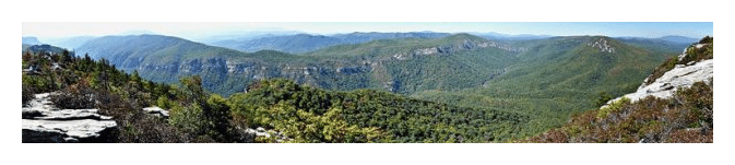
The Linville Gorge Wilderness Area, sometimes referred to as the "Grand Canyon of the East", is one of the wildest, most rugged gorges in the eastern United States. It's also an outdoor paradise for both hikers and backpackers.
Before the European settlers arrived the Cherokee Indians called it "Eseeoh," meaning a river of many cliffs. Today the Linville Gorge is named after explorer William Linville and his son, John, who were killed by Cherokees in the gorge in 1766.
The Linville Gorge Wilderness Area lies entirely within the Pisgah National Forest, and is managed by the Grandfather Ranger District of the U.S. Forest Service. It's located roughly 60 miles northeast of Asheville, and can be accessed via the Blue Ridge Parkway near milepost 314. The Gorge encompasses almost 12,000 acres around the Linville River, making it the third largest wilderness area in North Carolina, and one of only two wilderness gorges in the southern United States.
Formal protection for the wilderness began when land was purchased with funds donated by John D. Rockefeller in 1952. When the Wilderness Act was approved by Congress and signed into law in 1964, Linville Gorge became one of the first formally designated wilderness areas under the new National Wilderness Preservation System.
Elevations in the Gorge range from 1300 feet on the Linville River, to 4120 feet atop Gingercake Mountain. The terrain is extremely steep and rugged, with numerous rock formations, and is covered by a dense mixed forest of deciduous hardwood, pine and a wide variety of smaller trees and plants. The steep walls of Linville Gorge enclose the Linville River for nearly 12 miles as it descends roughly 1900 feet, before emerging onto the wide open plains of the Catawba Valley.
Linville Gorge is also rich in both plant and animal life. Visitors can find five species of rare plants, four species of rhododendron, as well as old-growth forests spared by the axe in many of the deep coves. The forests of the Gorge contain hickory, oak, maple, locust and poplar, as well as pockets of fir and Carolina hemlock. Visitors can also find sand myrtle, red chokeberry, azalea, turkey beard, bristly locust, yellow root, silverbell, orchids, ninebark, and wild indigo among the many plant species. Animals found in the Gorge include bear, deer, fox, raccoon, skunks, turkey, grouse, vultures, owls, hawks and peregrine falcons, as well as brown and rainbow trout in the river. Hikers should also be aware of copperheads and timber rattlers in the area as well.
Recreation opportunities in and around the Gorge include hiking, backpacking, mountain biking and rock climbing. Camping is allowed, but permits are required from May 1st through October 31st. Hunting and fishing are also allowed but permits are required as well.
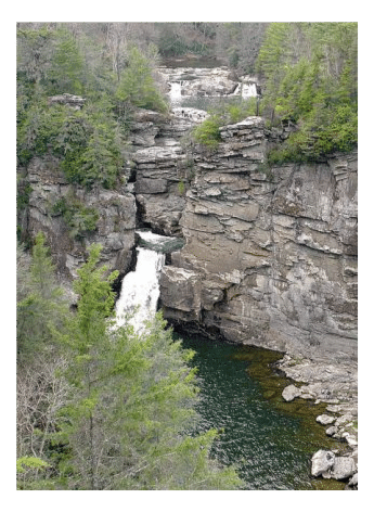
Some of the most popular tourist attractions in or near the Wilderness Area include Linville Falls, Wiseman's View (a rock outcropping near the center of the west rim that offers outstanding views), and Linville Caverns, a privately owned cave accessible from U.S. Route 221.
Hiking in the Linville Gorge Wilderness Area
There are 39 miles of trails that weave in and out of Linville Gorge. Hiking trails in the Gorge generally start along either of the two gravel forest service roads that traverse the east and west rims. Most of the footpaths lead down towards the river, meaning most trails traverse steep terrain, making for some rather strenuous and challenging hiking. At the bottom of the gorge is the longest trail in the wilderness area, the 11.5-mile Linville Gorge Trail which runs along the west side of the river.
Because this is a Federal Wilderness Area, hiking trails are not well marked or well maintained. It's extremely important for all hikers to carry a detailed trail map of the area before venturing out onto any of the trails. Beginners, and those without land navigation training, would be well advised to stick to the basic and shorter routes.
West Rim Trails
 Seven trails originate from the Kistler Memorial Highway / NC 1238 on the west rim of the Linville Gorge. A majority of these trails connect with the Linville Gorge Trail, a footpath that parallels the Linville River on its west side for roughly 11.5 miles.
Moving from north to south:
Linville Falls (2.8 miles): This hike offers five different perspectives of the waterfalls in two short sections. The first section, known as the Erwins View Trail, takes you to three overlooks where you'll appreciate the power of the water that carved the gorge (1.8 miles RT). The second section offers views of the lower falls as it plunges into a basin, and then into Linville River itself (1.0 mile RT). Additionally, there's another trail (1.4 miles RT) that leads you to Linville Gorge from this trailhead as well.
Pine Gap Trail (1 mile): Due to its relatively gradual descent, this is probably the easiest route into the gorge. The trail intersects with the Linville Gorge Trail at the bottom.
Bynum Bluff Trail (1 mile): This trail starts out gradually before plummeting down a sharp ridge to the bottom, making this a very strenuous hike.
Cabin Trail (0.75 miles): Another steep, strenuous and primitive trail that drops roughly 1000 feet in just three-quarters of a mile as it makes its way to the Linville Gorge Trail.
Babel Tower Trail (1.3 miles): Although a very strenuous hike, the Babel Tower Trail is one of the most popular and highly used trails for entering and exiting the gorge.
Sandy Flats (1 mile): This is a difficult and primitive side trail that descends to the river. Please note that according to Danny Bernstein, author of Hiking the Carolina Mountains, the Sandy Flats Trail was wiped out by hurricanes and the Forest Service has no plans to restore it.
Conley Cove Trail (1.35 miles): The heavily used Conley Cove Trail intersects with the Rock Jock Trail, which runs the rim of the canyon for roughly one mile before cresting back to the top of the gorge.
Rock Jock Trail (2.8 miles): A very primitive and difficult trail that hugs the west rim of the canyon for roughly one mile before cresting back to the top of the gorge.
Pinch In Trail (1.5 miles): The last trail out of the gorge on the west side is a notoriously steep and rugged trail that descends more than 2000 feet in only a little more than a mile!
East Rim Trails
Most of the east rim trails are accessed from Forest Road 210, off NC 181 south of Jonas Ridge. The trailhead for Devil's Hole, Jonas Ridge and a trail that leads to Table Rock and Hawksbill Mountain is located on the east rim off Gingercake Acres Road / SR 1265, which turns into FR 210. The Brushy Ridge Trail and the Shortoff Mountain Trail, which is part of the Mountains-to-Sea Trail, are accessed off Old Gingercake Road / SR 1264. To access the Table Rock Summit Trail, take Table Rock Road / NC 1265 off NC 181, then just south of Gingercake Road follow NC 1265 for 16 miles.
Moving from north to south:
Brushy Ridge (2 miles): This is another strenuous hike, but will satisfy those looking for an isolated hike that doesn't connect with any other trails in the wilderness. The first mile of the Brushy Ridge Trail uses an old forest road, making for easy hiking before it makes a sharp descent into the gorge. As you descend you'll enjoy spectacular views of Hawksbill, Table Rock, and Babel Tower above you.
Jonas Ridge (2.4 miles): This difficult and primitive trail takes hikers across the summit of Sitting Bear Mountain and towards Gingercake Mountain. You'll enjoy commanding views of the Linville Gorge, Hawksbill Mountain and Table Rock Mountain along the way.
Devils Hole Trail (1.5 miles): After a short climb near the start, the Devil's Hole Trail drops 1160 feet as it passes through a cove of rhododendron, hemlock, and oak. Near the bottom, after crossing a rocky stream, the trail makes a short climb to a cliff top before descending to the Linville River. When water levels are low, hikers may be able to rock-hop or wade across the river here to connect with the Linville Gorge Trail.
Spence Ridge Trail (1.75 miles): This is a popular trail and one of the easier routes to the bottom of the gorge. Because it offers a bridge across the Linville River, the Spence Ridge Trail can be included as part of a variety of loop hikes in the Gorge. The first 0.4 mile or so of the route traverses a fairly level old logging road. There are views of Hawksbill Mountain to the north, and Table Rock to the south. After passing the Little Table Rock Trail junction, the trail begins a relatively mild descent to the river where a bridge carries hikers to the west bank of the river, located at the intersection with the Linville Gorge Trail. This is the only bridge that crosses the river in the Gorge.
Little Table Rock Trail (1.1 Miles): A difficult and primitive trail that connects the Spence Ridge Trail with the Table Rock Trail.
Table Rock Summit Trail (1.2 miles): This is a strenuous but popular trail that leads to the 3930-foot summit of Table Rock. The summit offers panoramic, 360-degree views of the Linville Gorge, and is an ideal place for watching the annual hawk migration in September.
Chimbric Ridge Trail (1.3 miles): This trail is also known as the Cambric Branch Trail. Either way, it's a very difficult and very primitive trail that descends roughly 1500 feet to the river from the Shortoff Mountain Trail, just past Chimney Gap.
Shortoff Mountain Trail (8 miles): This is a very popular and heavily used trail. This ridgeline trail offers stunning views of the Appalachian Mountains on one side, and the farmlands of the piedmont on the other, with Lake James in the far-off distance. Portions of the Shortoff Mountain Trail are part of the Mountains-to-Sea Trail.
Other Trails
Linville Gorge Trail: The longest trail in the wilderness area is the 11.5-mile Linville Gorge Trail. It follows the Linville River from below Brushy Ridge near Linville Falls, to the wilderness boundary near Shortoff Mountain and Lake James. This heavily used trail descends along the western side of the river. Along the way it passes through hardwood forest, rugged cliffs, boulders and cascades.
Thru-hikers should expect a strenuous hike lasting at least two days, and must secure a permit for overnight stays between May 1st and October 31st.
Mountains-To-Sea Trail (11 Miles from rim to rim): The Mountains-to-Sea Trail stretches roughly 1150 miles across North Carolina, from Clingmans Dome in the Great Smoky Mountains to Jockey's Ridge on the Outer Banks. In Linville Gorge, the MST travels 27 miles from NC 181, to the Kistler Memorial Highway on the western rim.
From the eastern rim to the western rim, the trail covers 11 miles. It follows the eastern rim of Linville Gorge for much of its length, starting near Table Rock. The trail travels along the Shortoff Mountain Trail as it passes the Chimneys, before dropping down to cross the Linville River (no bridge) near the southern end of the gorge, and then continues onto the Kistler Memorial Highway on the western rim.
Mountain Biking: Some of the most popular mountain bike rides in the gorge include the 8.2-mile Wiseman's View Ride, the 26.2-mile Table Rock Loop, and the 49.2-mile Linville Gorge Loop. Bikers should note that mountain biking is not permitted within the Wilderness.
Key Links:
Pisgah National Forest: Grandfather Ranger District
Linville Gorge Driving Directions